 Lake Oroville Remains Full With temperatures remaining in the triple digits, Lake Oroville continues to remain at full capacity, offering ample water recreation and cooling opportunities for visitors. The Department of Water Resources (DWR) is adjusting water releases from the reservoir as needed to account for increasing or decreasing inflows while maintaining flood protection for downstream communities. Releases are closely coordinated with the U.S. Army Corps of Engineers and other water operators and adjusted as needed to maintain balance throughout the water system. DWR continues to monitor Lake Oroville levels to optimize water storage while meeting environmental requirements and allowing for carryover storage into next year. With Lake Oroville at full capacity, windy periods are likely to cause water to splash onto and over the crest of the emergency spillway. This will result in minor surface wetting of the downstream side of the emergency spillway crest and the very upper sections of the splash pad. Visitors to Oroville Dam may also notice minor amounts of water flowing from drains built into the emergency spillway. Both conditions are normal and expected given the emergency spillway design. The dam and emergency spillway continue to operate as intended. The information below reflects current reservoir level estimates. Forecasts can change quickly and may affect the estimates provided.
As the largest storage facility in the State Water Project, Lake Oroville helps provide water to 27 million Californians and 750,000 acres of farmland, while providing flood protection to downstream communities along with environmental and recreation benefits. Spring is an important time for water project operators to fill reservoirs like Lake Oroville ahead of dry months. It also is an important migration window for many native fish species. DWR is using the best available science to protect fish species. However, SWP operations have faced significant restrictions in the Delta this year that have impacted the ability in other areas of the state to capture and store the water needed if California sees a return to drought conditions.  MORE PRESCRIBED BURNS ANTICIPATED NEXT WEEK DWR, CAL FIRE/Butte County Fire Department, and the California Department of Parks and Recreation (State Parks) will continue prescribed burn activities near the Thermalito Afterbay and Forebay between Thursday, June 20 and Saturday, June 22. Approximately 120 acres will be burned near the Thermalito Afterbay between north Wilbur Road and Tres Vias Road. At the Thermalito Forebay, approximately 140 acres will be burned across three different locations – near Grand Avenue and the Thermalito South Forebay Recreation Area, and around the north Forebay area near Garden Drive and Nelson Park. CAL FIRE is using this controlled burn as a training mechanism for its employees. Fire personnel will utilize the burn to train on specific strategies and tactics associated with wildland fires and firing operations. The burns are part of DWR’s Thermalito Vegetation Management Project, which was established in 2021 to improve valley grassland and vernal pool habitat. They also have the added benefit of reducing dry brush near the Thermalito Forebay and Nelson Park in preparation for the City of Oroville’s Fourth of July fireworks showcase. Burn activities are dependent on favorable weather conditions with the schedule subject to change. Smoke from prescribed burning activities will be highly visible in the Oroville area next week. DWR, CAL FIRE, and the California Department of Fish and Wildlife (CDFW) previously completed a 100-acre prescribed burn along South Wilbur Road near the Afterbay to remove grasses and invasive vegetation. Annual grasses and other invasive species like the yellow starthistle degrade native grasslands and fire is a valuable tool to combat this degradation. Because invasive species have abundant seeds and dry material called thatch that build up on the soil, it is important to burn the same area multiple years in a row. When completed during the right stage in these species' growth cycle, the prescribed burns eradicate the current crop, reduce the dry residual thatch, and decrease the spread of seeds. The area has seen a significant decline in the volume of invasive grasses and starthistles since the project began. The burns also allow DWR to continue post-fire studies on vernal pool habitat. CALIFORNIA CLIMATE ADAPTATION STRATEGY The world’s leading climate scientists have made it clear - our window to avoid the worst impacts of climate change is narrowing faster than expected, and success requires unprecedented collective effort and transformational change. The California Natural Resources Agency (CNRA) recently released a draft of the 2024 update to the California Climate Adaptation Strategy and is seeking public feedback through July 12, 2024. The 2024 draft builds on the previously released 2021 Strategy and outlines the state's key climate resilience priorities, includes specific and measurable actions, and serves as a framework for collective efforts across California. CNRA is hosting a public workshop and community meeting on Tuesday, June 18 in Oroville to discuss the draft 2024 California Climate Adaptation Strategy and obtain feedback. Both meetings will be held at the Southside Oroville Community Center located at 2959 Lower Wyandotte Road, Oroville, CA. Food and refreshments will be provided at both sessions.
 OROVILLE RECREATION
Staffed by knowledgeable guides, the Visitor Center features interpretive displays on Oroville Dam, area geology, wildlife and habitat, hydroelectric power, and cultural and historical artifacts. View videos in the theater about the construction of Oroville Dam, walk or hike along nearby trails, and visit the 47-foot-tall observation tower that provides unsurpassed panoramic views of surrounding areas. Free guided tours for school and community groups are available by reservation. Parking and admission to the Visitor Center are free. DWR, State Parks, and CDFW maintain over 92 miles of trails in the Oroville area. An interactive map of recreation facilities, including open trails and their permitted uses (hike, bike, horse, multi), is available on DWR’s Lake Oroville Recreation webpage. A paper trail map is available at various locations, including most entrance kiosks and the Lake Oroville Visitor Center. Lake Oroville is one of the State Water Project’s premier recreational destinations and one of California’s best fishing spots. The lake provides both warm-water and cold-water fisheries and is a popular destination for bass tournaments. Below the Oroville Dam, the Thermalito Afterbay and the Feather River offer additional excellent fishing opportunities. The marinas at Bidwell Canyon and Lime Saddle are open daily and provide a variety of services including a convenience store, gas, and boat rentals. Upstream migrating fish totals through the Feather River Fish Monitoring Station between January 1 and June 10 are:
CURRENT LAKE OPERATIONS Lake Oroville is at 898 feet elevation and storage is approximately 3.51 million acre-feet (MAF), which is 99 percent of its total capacity and 127 percent of the historical average. Feather River flows are at 850 cfs through the City of Oroville with 2,950 cfs being released from the Thermalito Afterbay River Outlet (Outlet) for a total Feather River release of 3,800 cfs downstream. DWR continues to assess Feather River releases daily. The public can track precipitation, snow, reservoir levels and more at the California Data Exchange Center. The Lake Oroville gage station is identified as “ORO.” All data as of midnight 6/13/2024.  Lake Oroville Remains Full With temperatures reaching triple digits this week, Lake Oroville continues to remain at full capacity, offering ample water recreation and cooling opportunities for visitors. The Department of Water Resources (DWR) is adjusting water releases from the reservoir as needed to account for increasing or decreasing inflows while maintaining flood protection for downstream communities. Releases are closely coordinated with the U.S. Army Corps of Engineers and other water operators and adjusted as needed to maintain balance throughout the water system. DWR continues to monitor Lake Oroville levels to optimize water storage while meeting environmental requirements and allowing for carryover storage into next year. With Lake Oroville at full capacity, windy periods are likely to cause water to splash onto and over the crest of the emergency spillway. This will result in minor surface wetting of the downstream side of the emergency spillway crest and the very upper sections of the splash pad. Visitors to Oroville Dam may also notice minor amounts of water flowing from drains built into the emergency spillway. Both conditions are normal and expected given the emergency spillway design. The dam and emergency spillway continue to operate as intended. The information below reflects current reservoir level estimates. Forecasts can change quickly and may affect the estimates provided.
As the largest storage facility in the State Water Project, Lake Oroville helps provide water to 27 million Californians and 750,000 acres of farmland, while providing flood protection to downstream communities along with environmental and recreation benefits. Spring is an important time for water project operators to fill reservoirs like Lake Oroville ahead of dry months. It also is an important migration window for many native fish species. DWR is using the best available science to protect fish species. However, SWP operations have faced significant restrictions in the Delta this year that have impacted the ability in other areas of the state to capture and store the water needed if California sees a return to drought conditions.  EXPLORE THE LIME SADDLE RECREATION AREA Just a short drive from the town of Paradise, the Lime Saddle Recreation Area is located along the western shoreline of the North Fork arm of Lake Oroville and accessible from Pentz Road. The boat ramp and day use area features picnic tables, sun shelters, ADA accessible flush toilets, a fish cleaning station, and trash receptacles. A five-lane boat ramp provides access to Lake Oroville with two lanes extending down to 702 feet for lower water access. At the top of the boat ramp, a parking lot provides ample vehicle and trailer parking with ADA designated spots. In addition, the Lime Saddle Marina offers supplies, gas for boats, and boat rentals so you can enjoy a day on the lake. Nearby campgrounds also offer close access to the lake and are perfect for quick dips to combat the scorching heat. Lime Saddle Campground features 50 total campsites – 44 individual (28 car/tent sites and 16 RV sites with full hookups) and six group campsites. Each campsite features a picnic table and fire ring with grill. Bathroom facilities offer flush toilets and showers for visitors. Further north, the Lime Saddle Group Campground features six group campsites with shade structures, multiple picnic tables, trash receptacles, a large barbecue, and a water fountain with spigot. Three of the group campsites at this facility are ADA accessible with the central restroom/shower building also offering ADA accommodation. With Lake Oroville at full capacity, it’s also the perfect time for a hiking or biking trip along the Lime Saddle Trail offering scenic views of the full reservoir. The 1.73-mile trail is accessible from Lime Saddle Recreation Road (marina access road) and routes visitors north before ending at the Lime Saddle Group Campground. DWR, the California Department of Parks and Recreation (State Parks), and the California Department of Fish and Wildlife (CDFW) maintain over 92 miles of trails in the Oroville area. An interactive map of recreation facilities, including open trails and their permitted uses (hike, bike, horse, multi), is available on DWR’s Lake Oroville Recreation webpage. A paper trail map is available at various locations, including most entrance kiosks and the Lake Oroville Visitor Center.  PRESCRIBED BURN COMPLETE AT THE AFTERBAY DWR, CAL FIRE/Butte County Fire Department, and CDFW completed a 100-acre prescribed burn along South Wilbur Road near the Afterbay on June 6. The burn is part of DWR’s Thermalito Vegetation Management Project, which was established in 2021 to improve valley grassland and vernal pool habitat. Invasive annual grasses and other invasive species like the yellow starthistle degrade native grasslands and fire is a valuable tool to combat this degradation. Because invasive species have abundant seeds and dry material called thatch that build up on the soil, it is important to burn the same area multiple years in a row. When completed during the right stage in these species' growth cycle, the prescribed burns eradicate the current crop, reduce the dry residual thatch, and decrease the spread of seeds. The area has seen a significant decline in the volume of invasive grasses and starthistles since the project began. The burns also allow DWR to continue post-fire studies on vernal pool habitat. Further prescribed burns around the Forebay and Afterbay are also planned for June 20 and June 21. Burn activities are dependent on favorable weather conditions with the schedule subject to change. The upcoming burns also have the added benefit of reducing dry brush near the Thermalito Forebay in preparation for the City of Oroville’s Fourth of July fireworks showcase. Smoke from prescribed burning activities will be highly visible in the Oroville area in the coming weeks.  OROVILLE RECREATION
Lake Oroville is one of the State Water Project’s premier recreational destinations and one of California’s best fishing spots. The lake provides both warm-water and cold-water fisheries and is a popular destination for bass tournaments. Below the Oroville Dam, the Thermalito Afterbay and the Feather River offer additional excellent fishing opportunities. The marinas at Bidwell Canyon and Lime Saddle are open daily and provide a variety of services including a convenience store, gas, and boat rentals. Upstream migrating fish totals through the Feather River Fish Monitoring Station between January 1 and June 4 are:
CURRENT LAKE OPERATIONS Lake Oroville is at 899 feet elevation and storage is approximately 3.53 million acre-feet (MAF), which is 100 percent of its total capacity and 127 percent of the historical average. Feather River flows are at 850 cfs through the City of Oroville with 2,950 cfs being released from the Thermalito Afterbay River Outlet (Outlet) for a total Feather River release of 3,800 cfs downstream. DWR continues to assess Feather River releases daily. The public can track precipitation, snow, reservoir levels and more at the California Data Exchange Center. The Lake Oroville gage station is identified as “ORO.” All data as of midnight 6/6/2024.  DWR Maintaining Storage Capacity at Lake Oroville The Department of Water Resources (DWR) continues to maintain Lake Oroville at its peak storage capacity while adjusting water releases as needed to account for increasing or decreasing inflows into the reservoir and maintaining flood protection for downstream communities. Releases are closely coordinated with the U.S. Army Corps of Engineers and other water operators and adjusted as needed to maintain balance throughout the water system. DWR continues to monitor Lake Oroville levels to optimize water storage while meeting environmental requirements and allowing for carryover storage into next year. With Lake Oroville at full capacity, windy periods are likely to cause water to splash onto and over the crest of the emergency spillway. This will result in minor surface wetting of the downstream side of the emergency spillway crest and the very upper sections of the splash pad. Visitors to Oroville Dam may also notice minor amounts of water flowing from drains built into the emergency spillway. Both conditions are normal and expected given the emergency spillway design. The dam and emergency spillway continue to operate as intended. The information below reflects current reservoir level estimates. Forecasts can change quickly and may affect the estimates provided.
As the largest storage facility in the State Water Project, Lake Oroville helps provide water to 27 million Californians and 750,000 acres of farmland, while providing flood protection to downstream communities along with environmental and recreation benefits. Spring is an important time for water project operators to fill reservoirs like Lake Oroville ahead of dry months. It also is an important migration window for many native fish species. DWR is using the best available science to protect fish species. However, SWP operations have faced significant restrictions in the Delta this year that have impacted the ability to capture and store the water needed if California sees a return to drought conditions.  PRESCRIBED BURN SCHEDULED NEXT WEEK For the fourth straight year, DWR, CAL FIRE/Butte County Fire Department, and the California Department of Parks and Recreation (State Parks) will conduct a series of prescribed burns throughout the Thermalito Forebay and Thermalito Afterbay for vegetation management. The first prescribed burn is scheduled Wednesday, June 5 and will target approximately 100 acres along South Wilbur Road near the Afterbay. During the burn, a portion of Wilbur Road will be closed south of State Highway 162 due to low visibility and for the safety of fire crews. Further prescribed burns around the Forebay and Afterbay are also planned for June 20 and June 21. Burn activities are dependent on favorable weather conditions with the schedule subject to change. DWR’s Thermalito Vegetation Management Project was first conducted in 2021 to improve valley grassland and vernal pool habitat. Invasive annual grasses and other invasive species like the yellow starthistle degrade native grasslands and fire is a valuable tool to combat this degradation. Because invasive species have abundant seeds and dry material called thatch that build up on the soil, it is important to burn the same area multiple years in a row. When completed during the right stage in these species' growth cycle, the prescribed burns eradicate the current crop, reduce the dry residual thatch, and decrease the spread of seeds. The area has seen a significant decline in the volume of invasive grasses and starthistles since the project began. The burns also allow DWR to continue post-fire studies on vernal pool habitat. Upcoming prescribed burns also have the added benefit of reducing dry brush near the Thermalito Forebay in preparation for the City of Oroville’s Fourth of July fireworks showcase. Smoke from prescribed burning activities will be highly visible in the Oroville area in the coming weeks.  OROVILLE RECREATION
DWR, State Parks, and the California Department of Fish and Wildlife (CDFW) maintain over 92 miles of trails in the Oroville area. An interactive map of recreation facilities, including open trails and their permitted uses (hike, bike, horse, multi), is available on DWR’s Lake Oroville Recreation webpage. A paper trail map is available at various locations, including most entrance kiosks and the Lake Oroville Visitor Center. Staffed by knowledgeable guides, the Visitor Center features interpretive displays on Oroville Dam, area geology, wildlife and habitat, hydroelectric power, and cultural and historical artifacts. View videos in the theater about the construction of Oroville Dam, walk or hike along nearby trails, and visit the 47-foot-tall observation tower that provides unsurpassed panoramic views of surrounding areas. Free guided tours for school and community groups are available by reservation. Parking and admission to the Visitor Center are free. Lake Oroville is one of the State Water Project’s premier recreational destinations and one of California’s best fishing spots. The lake provides both warm-water and cold-water fisheries and is a popular destination for bass tournaments. Below the Oroville Dam, the Thermalito Afterbay and the Feather River offer additional excellent fishing opportunities. The marinas at Bidwell Canyon and Lime Saddle are open daily and provide a variety of services including a convenience store, gas, and boat rentals. Upstream migrating fish totals through the Feather River Fish Monitoring Station between Jan. 1 and May 26 are:
CURRENT LAKE OPERATIONS Lake Oroville is at 899 feet elevation and storage is approximately 3.53 million acre-feet (MAF), which is 100 percent of its total capacity and 125 percent of the historical average. Feather River flows are at 650 cfs through the City of Oroville with 2,950 cfs being released from the Thermalito Afterbay River Outlet (Outlet) for a total Feather River release of 3,600 cfs downstream. DWR continues to assess Feather River releases daily. The public can track precipitation, snow, reservoir levels, and more at the California Data Exchange Center. The Lake Oroville gage station is identified as “ORO.” All data as of midnight 5/30/2024.  DWR Maintaining Storage Capacity at Lake Oroville The Department of Water Resources (DWR) continues to maintain Lake Oroville at its peak storage capacity while adjusting water releases as needed to account for increasing or decreasing inflows into the reservoir and maintaining flood protection for downstream communities. Releases are closely coordinated with the U.S. Army Corps of Engineers and other water operators and adjusted as needed to maintain balance throughout the water system. DWR continues to monitor Lake Oroville levels to optimize water storage while meeting environmental requirements and allowing for carryover storage into next year. With Lake Oroville at full capacity, windy periods are likely to cause water to splash onto and over the crest of the emergency spillway. This will result in minor surface wetting of the downstream side of the emergency spillway crest and the very upper sections of the splash pad. Visitors to Oroville Dam may also notice minor amounts of water flowing from drains built into the emergency spillway. Both conditions are normal and expected given the emergency spillway design. The dam and emergency spillway continue to operate as intended. The information below reflects current reservoir level estimates. Forecasts can change quickly and may affect the estimates provided.
As the largest storage facility in the State Water Project, Lake Oroville helps provide water to 27 million Californians and 750,000 acres of farmland, while providing flood protection to downstream communities along with environmental and recreation benefits. Spring is an important time for water project operators to fill reservoirs like Lake Oroville ahead of dry months. It also is an important migration window for many native fish species. DWR is using the best available science to protect fish species. However, SWP operations have faced significant restrictions in the Delta this year that have impacted the ability to capture and store the water needed if California sees a return to drought conditions.  SWIM BEACHES Temperatures are warming up in Northern California and summer is just around the corner. While Lake Oroville offers ample water opportunities for boating, kayaking or wakeboarding, the Lake Oroville State Recreation Area (LOSRA) and Oroville Wildlife Area (OWA) also offer several family-friendly swim beaches that are excellent locations to recreate. Swim beaches within the LOSRA and OWA provide shallow wading and swimming opportunities for visitors of all ages with nearby restroom facilities. Some locations also include picnic benches and barbecue facilities that are perfect for hosting a fun family gathering. Beat the heat and relax at one of our swim beaches – Loafer Creek at Lake Oroville, Monument Hill or Larkin Road at the Thermalito Afterbay, or the South or North Thermalito Forebay. When recreating at SWP facilities, you should always keep water safety a top priority. Keep these water safety tips in mind to have a fun and safe summer:
 DRIFTWOOD ABATEMENT ONGOING AT LAKE OROVILLE For the second year in a row, Lake Oroville has filled to capacity following a wet winter. But high water levels also bring driftwood and other floating debris as water flows into Lake Oroville from tributaries. Since the end of April, DWR civil maintenance staff have been collecting, containing, and pulling pieces of wood out of the lake and away from shoreline areas using boom lines. So far DWR civil maintenance crews have collected over an acre of driftwood with abatement activities expected to continue for the next several weeks. Crews are seeing much less floating debris this season due to lower inflows from tributaries coupled with extensive debris removal efforts in 2023. Floating debris removal ensures continued infrastructure operations and the safety of the recreating public on Lake Oroville. However, boaters, water skiers, and other water recreationists should take precautions when operating boats on Lake Oroville and should remain alert for floating debris.  OROVILLE RECREATION
DWR, State Parks, and the California Department of Fish and Wildlife (CDFW) maintain over 92 miles of trails in the Oroville area. An interactive map of recreation facilities, including open trails and their permitted uses (hike, bike, horse, multi), is available on DWR’s Lake Oroville Recreation webpage. A paper trail map is available at various locations, including most entrance kiosks and the Lake Oroville Visitor Center. Staffed by knowledgeable guides, the Visitor Center features interpretive displays on Oroville Dam, area geology, wildlife and habitat, hydroelectric power, and cultural and historical artifacts. View videos in the theater about the construction of Oroville Dam, walk or hike along nearby trails, and visit the 47-foot-tall observation tower that provides unsurpassed panoramic views of surrounding areas. Free guided tours for school and community groups are available by reservation. Parking and admission to the Visitor Center are free. Lake Oroville is one of the State Water Project’s premier recreational destinations and one of California’s best fishing spots. The lake provides both warm-water and cold-water fisheries and is a popular destination for bass tournaments. Below the Oroville Dam, the Thermalito Afterbay and the Feather River offer additional excellent fishing opportunities. The marinas at Bidwell Canyon and Lime Saddle are open daily and provide a variety of services including a convenience store, gas, and boat rentals. Upstream migrating fish totals through the Feather River Fish Monitoring Station between Jan. 1 and May 19 are:
CURRENT LAKE OPERATIONS Lake Oroville is at 898 feet elevation and storage is approximately 3.52 million acre-feet (MAF), which is 99 percent of its total capacity and 126 percent of the historical average. Feather River flows are at 650 cfs through the City of Oroville with 1,650 cfs being released from the Thermalito Afterbay River Outlet (Outlet) for a total Feather River release of 2,300 cfs downstream. Total Feather River releases may be further reduced over the weekend. DWR continues to assess Feather River releases daily. The public can track precipitation, snow, reservoir levels, and more at the California Data Exchange Center. The Lake Oroville gage station is identified as “ORO.” All data as of midnight 5/23/2024.  Lake Oroville Reaches Full Capacity Two Years in a Row While the new water year began with warm and dry conditions, the Feather River watershed received enough precipitation and snowpack runoff in the first months of 2024 to fill Lake Oroville to capacity for the second year in a row. The Department of Water Resources (DWR) continues to adjust Lake Oroville water releases as needed to account for increasing or decreasing inflows into the reservoir and maintain flood protection for downstream communities. Releases are closely coordinated with the U.S. Army Corps of Engineers and other water operators and adjusted as needed to maintain balance throughout the water system. With Lake Oroville at full capacity, windy periods are likely to cause water to splash onto and over the crest of the emergency spillway. This will result in minor surface wetting of the downstream side of the emergency spillway crest and the very upper sections of the splash pad. Visitors to Oroville Dam may also notice minor amounts of water flowing from drains built into the emergency spillway. Both conditions are normal and expected given the emergency spillway design. The dam and emergency spillway continue to operate as intended. The information below reflects current reservoir level estimates. Forecasts can change quickly and may affect the estimates provided.
As the largest storage facility in the State Water Project, Lake Oroville helps provide water to 27 million Californians and 750,000 acres of farmland, while providing flood protection to downstream communities along with environmental and recreation benefits. Spring is an important time for water project operators to fill reservoirs like Lake Oroville ahead of dry months. It also is an important migration window for many native fish species. DWR is using the best available science to protect fish species. However, SWP operations have faced significant restrictions in the Delta this year that have impacted the ability to capture and store the water needed if California sees a return to drought conditions. DWR continues to monitor Lake Oroville levels and mountain snow levels to optimize water storage while meeting environmental requirements and allowing for carryover storage into next year.  DRIFTWOOD ABATEMENT ONGOING AT LAKE OROVILLE For the second year in a row, Lake Oroville has filled to capacity following a wet winter. But high water levels also bring driftwood and other floating debris as water flows into Lake Oroville from tributaries. Since the end of April, DWR civil maintenance staff have been collecting, containing, and pulling pieces of wood out of the lake and away from shoreline areas using boom lines. So far DWR civil maintenance crews have collected over an acre of driftwood with abatement activities expected to continue for the next several weeks. Crews are seeing much less floating debris this season due to lower inflows from tributaries coupled with extensive debris removal efforts in 2023. Floating debris removal ensures continued infrastructure operations and the safety of the recreating public on Lake Oroville. However, boaters, water skiers, and other water recreationists should take precautions when operating boats on Lake Oroville and should remain alert for floating debris. The State Water Project’s (SWP) reservoirs located throughout California will again welcome the upcoming summer months with high water levels. Storms this past winter will also bring fast flows and cold temperatures to rivers and streams as mountain snow melts. When recreating at SWP facilities, you should always keep water safety a top priority and stay alert for cold, fast, and fluctuating water conditions. As part of Water Safety Month, keep these water safety tips in mind to have a fun and safe summer:
 GOLD FLAT LOOP CAMPGROUND REOPENS The California Department of Parks and Recreation (State Parks) has reopened the Bidwell Canyon Gold Flat Loop Campground at the Lake Oroville State Recreation Area following extensive ADA site upgrades. In addition to repaving campground access roads, three of the 37 tent/RV camping sites received accessibility upgrades with parking stalls and a clear path of travel to accessible restroom and shower facilities. Upgrades to the campground also included new water and sewer facilities to complement new power hookups that were completed in recent years. The Gold Flat Loop Campground is conveniently located near the popular Bidwell Canyon Marina and provides nearby access to the Bidwell Canyon Trail (hiking/biking) and the Dan Beebe Trail (hiking/equestrian). With Lake Oroville at full capacity, now is the perfect time to reserve a campsite and enjoy the numerous recreation opportunities available at Lake Oroville. Book your Lake Oroville stay at reservecalifornia.com.  OROVILLE RECREATION
DWR, State Parks, and the California Department of Fish and Wildlife (CDFW) maintain over 92 miles of trails in the Oroville area. An interactive map of recreation facilities, including open trails and their permitted uses (hike, bike, horse, multi), is available on DWR’s Lake Oroville Recreation webpage. A paper trail map is available at various locations, including most entrance kiosks and the Lake Oroville Visitor Center. Staffed by knowledgeable guides, the Visitor Center features interpretive displays on Oroville Dam, area geology, wildlife and habitat, hydroelectric power, and cultural and historical artifacts. View videos in the theater about the construction of Oroville Dam, walk or hike along nearby trails, and visit the 47-foot-tall observation tower that provides unsurpassed panoramic views of surrounding areas. Free guided tours for school and community groups are available by reservation. Parking and admission to the Visitor Center are free. Lake Oroville is one of the State Water Project’s premier recreational destinations and one of California’s best fishing spots. The lake provides both warm-water and cold-water fisheries and is a popular destination for bass tournaments. Below the Oroville Dam, the Thermalito Afterbay and the Feather River offer additional excellent fishing opportunities. The marinas at Bidwell Canyon and Lime Saddle are open daily and provide a variety of services including a convenience store, gas, and boat rentals. Upstream migrating fish totals through the Feather River Fish Monitoring Station between Jan. 1 and May 14 are:
CURRENT LAKE OPERATIONS Lake Oroville is at 899 feet elevation and storage is approximately 3.52 million acre-feet (MAF), which is 100 percent of its total capacity and 127 percent of the historical average. Feather River flows are at 1,100 cfs through the City of Oroville with 5,850 cfs being released from the Thermalito Afterbay River Outlet (Outlet) for a total Feather River release of 6,950 cfs downstream. DWR continues to assess Feather River releases daily. The public can track precipitation, snow, reservoir levels, and more at the California Data Exchange Center. The Lake Oroville gage station is identified as “ORO.” All data as of midnight 5/16/2024.   Feather River Pulse Flow to Benefit Migrating Fish With warming temperatures and the mountain snowmelt season underway, the Department of Water Resources (DWR) continues to perform required flood protection releases from Lake Oroville using the Hyatt Powerplant. Releases from Lake Oroville during the spring months help maintain storage capacity in the reservoir to capture runoff, while optimizing storage for the benefit of water supply, recreation, and fish and wildlife enhancement. Over the past week, DWR has further decreased total releases from Lake Oroville to account for reduced inflows into the reservoir. DWR coordinates releases closely with the U.S. Army Corps of Engineers and other water operators and adjusts releases as needed to maintain balance throughout the water system. The information below reflects current reservoir level estimates. Forecasts can change quickly and may affect the estimates provided.
Reductions are in anticipation of a pulse flow, a temporary increase in river flow, which is scheduled to start Tuesday, April 23. Pulse flows benefit migrating fish such as juvenile salmon and steelhead, that are traveling downstream this time of year. Pulse flows increase their survival by increasing the speed at which juvenile salmon and steelhead move downstream, reducing their exposure to predators and potential infection from pathogens. Pulse flows during the winter and spring mimic natural river hydrologic conditions that the salmon and steelhead, along with many other Central Valley riverine species, have adapted to over many eons. Pulse flows were developed in coordination with the California Department of Fish and Wildlife (CDFW) and National Marine Fisheries Service (NMFS) for the benefit of salmon migrating out of the Feather River. During the pulse flow period, the Low Flow Channel will remain at 650 cfs, while total Feather River releases will increase to 6,450 cfs. It is expected that flows will be reduced again by Saturday, April 27. Lake Oroville is the largest storage facility in the State Water Project, providing flood protection while supporting environmental and water delivery needs to 27 million Californians. DWR continues to monitor lake levels, weather forecasts, and mountain snow levels to optimize water storage while meeting environmental requirements and allowing for carryover storage into next year.  Oroville Wildlife Area Plantings Support Native and Migratory Birds The nearly 12,000-acre Oroville Wildlife Area (OWA) in Butte County is a popular stopping place on the Pacific Flyway for migrating and native birds thanks to its preservation as a wildlife habitat and its proximity to the Thermalito Afterbay and Feather River. Under the management of CDFW, nearly 300 acres of grains, grasses, and flowering plants are sown yearly to provide food (forage), shelter, and nesting cover for migratory and native birds. This spring, CDFW has begun the planting season with 60 acres of sunflower and safflower seeds at 16 different locations around the Thermalito Afterbay. Growing different types of grains, grasses, and flowers provides nutrition for different varieties of birds and wildlife, and safflower and black oil sunflower seeds provide the most energy per pound of any typical birdseed. Both safflowers and sunflowers thrive best in arid climates and dry conditions like those found in the north Sacramento Valley where the OWA is located. However, planting at the OWA does present a challenge due to a lack of an irrigation system. CDFW staff instead utilize dry-land farming techniques including minimal land tilling, wider than normal spacing, and the selection of crops best suited for the environment. CDFW staff have been planting forage in the OWA for over 50 years and have a successful track record of timing the weather with their plowing and seeding activities to provide a welcome bounty of high-energy food and shelter for the Valley’s native birds and migrating visitors.  Brad Freeman Trail Reroute Heavy rains caused slope failure along a portion of the Brad Freeman Trail near the Hyatt Powerplant, making a quarter mile long trail section unsafe for public recreation. DWR and the California Department of Parks and Recreation (State Parks) assessed impacts to the trail with a decision ultimately made to reroute the trail for continued recreation use. DWR and State Parks opened the newly rerouted trail this week, which now runs along the north side of Oro Powerhouse Road. The trail reroute provides continuous access to the 41-mile-long Brad Freeman Trail loop, offering multi-use recreation for hiking, biking, and equestrians. The nearest access points to this trail segment are the Diversion Pool parking lot off Oro Powerhouse Road and the Upper Overlook Day Use Area on Canyon Drive. DWR, State Parks, and CDFW maintain over 92 miles of trails in the Oroville area. An interactive map of recreation facilities, including open trails and their permitted uses (hike, bike, horse, multi), is available on DWR’s Lake Oroville Recreation webpage. A paper trail map is available at various locations, including most entrance kiosks and the Lake Oroville Visitor Center.  Earth Day Activities Celebrate Earth Day with DWR and the Lake Oroville Visitor Center. Our Visitor Center guides are hosting an Earth Day chalk art event this Saturday, April 20 from 10 a.m. to 3 p.m. Join our staff in creating beautiful chalk art showcasing your love for our planet and its precious resources. The event is open to all ages and chalk will be provided. Located at 917 Kelly Ridge Rd. in Oroville, the Visitor Center is open daily from 9 a.m. to 5 p.m. Staffed by knowledgeable guides, the Visitor Center features interpretive displays on Oroville Dam, area geology, wildlife and habitat, hydroelectric power, and cultural and historical artifacts. View videos in the theater about the construction of Oroville Dam, walk or hike along nearby trails, and visit the 47-foot-tall observation tower that provides unsurpassed panoramic views of surrounding areas. Free guided tours for school and community groups are available by reservation. Parking and admission to the Visitor Center are free. 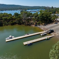 Oroville Recreation
Lake Oroville is one of the State Water Project’s premier recreational destinations and one of California’s best fishing spots. The lake provides both warm-water and cold-water fisheries and is a popular destination for bass tournaments. Below the Oroville Dam, the Thermalito Afterbay and the Feather River offer additional excellent fishing opportunities. The marinas at Bidwell Canyon and Lime Saddle are open daily and provide a variety of services including a convenience store, gas, and boat rentals. Upstream migrating fish totals through the Feather River Fish Monitoring Station between Jan. 1 and April 11 are:
Current Lake Operations Lake Oroville is at 881 feet elevation and storage is approximately 3.25 million acre-feet (MAF), which is 92 percent of its total capacity and 123 percent of the historical average. Feather River flows are at 650 cfs through the City of Oroville with 4,350 cfs being released from the Thermalito Afterbay River Outlet (Outlet) for a total Feather River release of 5,000 cfs downstream. On Saturday, total Feather River releases will be reduced to 3,500 cfs while maintaining 650 cfs in the Low Flow Channel. Thermalito Afterbay River Outlet releases will be reduced to 2,850 cfs. DWR continues to assess releases to the Feather River daily. Visitors to Oroville Dam may also notice minor amounts of water flowing from drains built into the emergency spillway, which is normal and expected with the emergency spillway design. The dam and emergency spillway continue to operate as intended. The public can track precipitation, snow, reservoir levels, and more at the California Data Exchange Center. The Lake Oroville gage station is identified as “ORO.” All data as of midnight 4/18/2024. California Department of Water Resources715 P Street Sacramento, CA 95814 Call our general information line at 916-820-8142 or email us at [email protected]  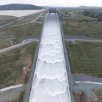 Main Spillway Releases Ongoing As snowmelt season begins, the Department of Water Resources (DWR) continues to perform flood protection releases from Lake Oroville using the main spillway and Hyatt Powerplant. Releases from Lake Oroville during the spring months help maintain storage capacity in the reservoir to capture runoff from mountain snowmelt, while optimizing storage for the benefit of water supply, recreation, and fish and wildlife enhancement. DWR coordinates releases closely with the U.S. Army Corps of Engineers and other water operators and adjusts releases as needed to maintain balance throughout the water system. The information below reflects current reservoir level estimates. Forecasts can change quickly and may affect the estimates provided.
Lake Oroville is the largest storage facility in the State Water Project, providing flood protection while supporting environmental and water delivery needs to 27 million Californians. In 2023, Oroville Dam’s main spillway passed over 2,370,000 acre-feet of water, 67 percent of Lake Oroville’s capacity, with flows as high as 36,000 cfs. The main spillway continues to perform well and operate as designed. DWR continues to monitor lake levels, weather forecasts, and mountain snow levels to optimize water storage while meeting environmental requirements and allowing for carryover storage into next year.  ABOVE AVERAGE SNOWPACK RECORDED DURING APRIL SNOW SURVEY DWR conducted the all-important April snow survey on April 2, the fourth measurement of the season at Phillips Station. The manual survey recorded 64 inches of snow depth and a snow water equivalent of 27.5 inches, which is 113 percent of average for this location. The snow water equivalent measures the amount of water contained in the snowpack and is a key component of DWR’s water supply forecast. The April measurement is critical for water managers as it’s considered the peak snowpack for the season and marks the transition to spring snowmelt into the state’s rivers and reservoirs. DWR’s electronic readings from 130 stations placed throughout the state indicate that the statewide snowpack’s snow water equivalent is 28.6 inches, or 110 percent of the April 1 average, a significant improvement from just 28 percent of average on January 1. California’s reservoirs remain in good shape thanks to state efforts to capture and store as much water as possible from record storms in 2023 and again this season. The State Water Project has increased storage by 700,000 acre-feet at Lake Oroville and by 154,000 acre-feet at San Luis Reservoir since January 1. As of April 2, statewide reservoir levels were at 116 percent of average. Read more about the April snow survey in DWR’s press release.  OROVILLE WILDFLOWER & NATURE FESTIVAL The Feather River Recreation & Park District (FRRPD) is hosting its annual Wildflower & Nature Festival at Riverbend Park in Oroville on Saturday, April 6 from 10 a.m. to 4 p.m. Admission is free to the festival with activities highlighting the area’s natural resources and booths showcasing handmade Butte County products. Activities and entertainment will be available for all ages including children’s crafts, river kayak tours, live music, food trucks, and a beer and wine garden. Make sure to stop by DWR’s booth for information about the Lake Oroville Visitor Center and Lake Oroville State Recreation Area, and a craft activity for kids – making wildflower seed paper. More information about the Wildflower & Nature Festival is available on FRRPD’s website. 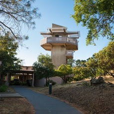 EARTH DAY ACTIVITIES Celebrate Earth Day all April with DWR and the Lake Oroville Visitor Center. Our Visitor Center guides are currently hosting a coloring contest for kids ages 5 to 12. Pick up coloring sheets at the Visitor Center and return them or your own original Earth Day artwork by Wednesday, April 17. Winners will have their art displayed publicly in the Visitor Center’s front lobby. In addition, DWR is hosting an Earth Day chalk art event at the Lake Oroville Visitor Center on Saturday, April 20 from 10 a.m. to 3 p.m. Join our guides in creating beautiful chalk art showcasing your love for our planet and its precious resources. The event is open to all ages and chalk will be provided. Located at 917 Kelly Ridge Rd. in Oroville, the Visitor Center is open daily from 9 a.m. to 5 p.m.  OROVILLE RECREATION
DWR, the California Department of Parks and Recreation, and the California Department of Fish and Wildlife (CDFW) maintain over 92 miles of trails in the Oroville area. An interactive map of recreation facilities, including open trails and their permitted uses (hike, bike, horse, multi), is available on DWR’s Lake Oroville Recreation webpage. A paper trail map is available at various locations, including most entrance kiosks and the Lake Oroville Visitor Center. Lake Oroville is one of the State Water Project’s premier recreational destinations and one of California’s best fishing spots. The lake provides both warm-water and cold-water fisheries and is a popular destination for bass tournaments. Below the Oroville Dam, the Thermalito Afterbay and the Feather River offer additional excellent fishing opportunities. The marinas at Bidwell Canyon and Lime Saddle are open daily and provide a variety of services including a convenience store, gas, and boat rentals. Upstream migrating fish totals through the Feather River Fish Monitoring Station between Jan. 1 and March 30 are:
CURRENT LAKE OPERATIONS Lake Oroville is at 873 feet elevation and storage is approximately 3.12 million acre-feet (MAF), which is 88 percent of its total capacity and 123 percent of the historical average. Feather River flows are at 1,000 cfs through the City of Oroville with 9,000 cfs being released from the Thermalito Afterbay River Outlet (Outlet) for a total Feather River release of 10,000 cfs downstream. Total Feather River releases may be reduced over the weekend depending on observed storm impacts. DWR continues to assess releases to the Feather River daily. Visitors to Oroville Dam may also notice minor amounts of water flowing from drains built into the emergency spillway, which is normal and expected with the emergency spillway design. The dam and emergency spillway continue to operate as intended. The public can track precipitation, snow, reservoir levels, and more at the California Data Exchange Center. The Lake Oroville gage station is identified as “ORO.” All data as of midnight 4/4/2024. 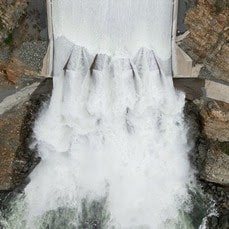 Main Spillway Releases Ongoing As snowmelt season begins, the Department of Water Resources (DWR) continues to perform flood protection releases from Lake Oroville using the main spillway and Hyatt Powerplant. Releases from Lake Oroville during the spring months help maintain storage capacity in the reservoir to capture runoff from mountain snowmelt, while optimizing storage for the benefit of water supply, recreation, and fish and wildlife enhancement. DWR coordinates releases closely with the U.S. Army Corps of Engineers and other water operators and adjusts releases as needed to maintain balance throughout the water system. The information below reflects current reservoir level estimates. Forecasts can change quickly and may affect the estimates provided.
Lake Oroville is the largest storage facility in the State Water Project, providing flood protection while supporting environmental and water delivery needs to 27 million Californians. In 2023, Oroville Dam’s main spillway passed over 2,370,000 acre-feet of water, 67 percent of Lake Oroville’s capacity, with flows as high as 36,000 cfs. The main spillway continues to perform well and operate as designed. DWR continues to monitor lake levels, weather forecasts, and mountain snow levels to optimize water storage while meeting environmental requirements and allowing for carryover storage into next year. 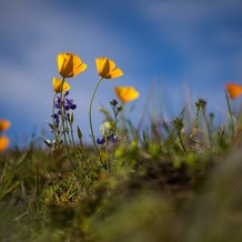 OROVILLE WILDFLOWER & NATURE FESTIVAL The Feather River Recreation & Park District (FRRPD) is hosting its annual Wildflower & Nature Festival at Riverbend Park in Oroville on Saturday, April 6 from 10 a.m. to 4 p.m. Admission is free to the festival with activities highlighting the area’s natural resources and booths showcasing handmade Butte County products. Activities and entertainment will be available for all ages including children’s crafts, river kayak tours, live music, food trucks, and a beer and wine garden. Make sure to stop by DWR’s booth for information about the Lake Oroville Visitor Center and Lake Oroville State Recreation Area, and a craft activity for kids – making wildflower seed paper. More information about the Wildflower & Nature Festival is available on FRRPD’s website.  EARTH DAY ACTIVITIES Celebrate Earth Day all April with DWR and the Lake Oroville Visitor Center. Our Visitor Center guides are currently hosting a coloring contest for kids ages 5 to 12. Pick up coloring sheets at the Visitor Center and return them or your own original Earth Day artwork by Wednesday, April 17. Winners will have their art displayed publicly in the Visitor Center’s front lobby. In addition, DWR is hosting an Earth Day chalk art event at the Lake Oroville Visitor Center on Saturday, April 20 from 10 a.m. to 3 p.m. Join our guides in creating beautiful chalk art showcasing your love for our planet and its precious resources. The event is open to all ages and chalk will be provided. Located at 917 Kelly Ridge Rd. in Oroville, the Visitor Center is open daily from 9 a.m. to 5 p.m.  OROVILLE RECREATION
DWR, the California Department of Parks and Recreation, and the California Department of Fish and Wildlife (CDFW) maintain over 92 miles of trails in the Oroville area. An interactive map of recreation facilities, including open trails and their permitted uses (hike, bike, horse, multi), is available on DWR’s Lake Oroville Recreation webpage. A paper trail map is available at various locations, including most entrance kiosks and the Lake Oroville Visitor Center. Lake Oroville is one of the State Water Project’s premier recreational destinations and one of California’s best fishing spots. The lake provides both warm-water and cold-water fisheries and is a popular destination for bass tournaments. Below the Oroville Dam, the Thermalito Afterbay and the Feather River offer additional excellent fishing opportunities. The marinas at Bidwell Canyon and Lime Saddle are open daily and provide a variety of services including a convenience store, gas, and boat rentals. Upstream migrating fish totals through the Feather River Fish Monitoring Station between Jan. 1 and March 18 are:
CURRENT LAKE OPERATIONS Lake Oroville is at 870 feet elevation and storage is approximately 3.08 million acre-feet (MAF), which is 87 percent of its total capacity and 124 percent of the historical average. Feather River flows are at 1,000 cfs through the City of Oroville with 9,000 cfs being released from the Thermalito Afterbay River Outlet (Outlet) for a total Feather River release of 10,000 cfs downstream. DWR continues to assess releases to the Feather River daily. Visitors to Oroville Dam may also notice minor amounts of water flowing from drains built into the emergency spillway, which is normal and expected with the emergency spillway design. The dam and emergency spillway continue to operate as intended. The public can track precipitation, snow, reservoir levels, and more at the California Data Exchange Center. The Lake Oroville gage station is identified as “ORO.” All data as of midnight 3/28/2024.  Main Spillway Releases Ongoing The Department of Water Resources (DWR) continues to perform flood protection releases from Lake Oroville using the main spillway and Hyatt Powerplant. Releases from Lake Oroville during the winter and spring months help maintain storage capacity in the reservoir for rain capture and future snowmelt. DWR coordinates releases closely with the U.S. Army Corps of Engineers and other water operators and adjusts releases as needed to account for continuing runoff. The information below reflects current reservoir level estimates. Forecasts can change quickly and may affect the estimates provided.
Crews may also be seen working near the main spillway for several weeks. Sections of the spillway’s underdrain system are being re-inspected to capture additional video footage. In addition, crews will be performing maintenance and repairs to the spillway’s lighting system. Lake Oroville is the largest storage facility in the State Water Project, providing flood protection while supporting environmental and water delivery needs to 27 million Californians. In 2023, Oroville Dam’s main spillway passed over 2,370,000 acre-feet of water, 67 percent of Lake Oroville’s capacity, with flows as high as 36,000 cfs. The main spillway continues to perform well and operate as designed. DWR continues to monitor lake levels, weather forecasts, and mountain snow levels to optimize water storage while meeting environmental requirements and allowing for carryover storage into next year.  TEMPORARY TRAIL CLOSURE IN POTTER’S RAVINE AREA DWR and the California Department of Parks and Recreation (State Parks) have temporarily closed a section of Dead Cow Ravine Trail in the Potter’s Ravine area at the Lake Oroville State Recreation Area. Recreation users can still access the north section of Dead Cow Ravine Trail to Gobbler’s Knob from the Potter’s Point trail. The trail is anticipated to remain closed and be considered an environmentally sensitive area through July 31, 2024. Additionally, wire theft and vandalism have rendered the lighting system within the Brad Freeman Bike Trail’s historic train tunnel inoperable and beyond repair. DWR is designing an entirely new lighting system with construction anticipated in late 2024. The trail will remain open, but users are advised to bring their own light to navigate the train tunnel. DWR, State Parks, and the California Department of Fish and Wildlife (CDFW) maintain over 92 miles of trails in the Oroville area. An interactive map of recreation facilities, including open trails and their permitted uses (hike, bike, horse, multi), is available on DWR’s Lake Oroville Recreation webpage. A paper trail map is available at various locations, including most entrance kiosks and the Lake Oroville Visitor Center.  EXPLORE TABLE MOUNTAIN Formed from ancient lava flows, the 3,300-acre North Table Mountain Ecological Reserve is a flat-topped mesa providing spectacular views of the valley below. Following winter rains, fissures along the vast lava caps form natural streams, vernal pools, and waterfalls that cascade off the plateau to the valley below. March is a spectacular time to enjoy miles of hiking trails through the reserve to view an array of wildflowers in bloom and an expansive carpet of green grasses. Cattle grazing on the reserve is used as a management tool to reduce thatch and non-native grass species to benefit native plants. More information about visiting the ecological reserve may be found on the California Department of Fish and Wildlife's (CDFW) website.  OROVILLE RECREATION
The Lake Oroville Visitor Center is open daily from 9 a.m. to 5 p.m. Staffed by knowledgeable guides, the Visitor Center features interpretive displays on Oroville Dam, area geology, wildlife and habitat, hydroelectric power, and cultural and historical artifacts. View videos in the theater about the construction of Oroville Dam, walk or hike along nearby trails, and visit the 47-foot-tall observation tower that provides unsurpassed panoramic views of surrounding areas. Free guided tours for school and community groups are available by reservation. Parking and admission to the Visitor Center are free. Lake Oroville is one of the State Water Project’s premier recreational destinations and one of California’s best fishing spots. The lake provides both warm-water and cold-water fisheries and is a popular destination for bass tournaments. Below the Oroville Dam, the Thermalito Afterbay and the Feather River offer additional excellent fishing opportunities. The marinas at Bidwell Canyon and Lime Saddle are open daily and provide a variety of services including a convenience store, gas, and boat rentals. Upstream migrating fish totals between Jan. 1 and March 9 are:
CURRENT LAKE OPERATIONS Lake Oroville is at 866 feet elevation and storage is approximately 3.03 million acre-feet (MAF), which is 86 percent of its total capacity and 125 percent of the historical average. Feather River flows are at 1,000 cfs through the City of Oroville with 9,000 cfs being released from the Thermalito Afterbay River Outlet (Outlet) for a total Feather River release of 10,000 cfs downstream. Releases may be adjusted over the weekend or early next week to account for storm impacts and higher inflows into Lake Oroville. DWR continues to assess releases to the Feather River daily. Visitors to Oroville Dam may also notice minor amounts of water flowing from drains built into the emergency spillway, which is normal and expected with the emergency spillway design. The dam and emergency spillway continue to operate as intended. The public can track precipitation, snow, reservoir levels, and more at the California Data Exchange Center. The Lake Oroville gage station is identified as “ORO.” All data as of midnight 3/21/2024. 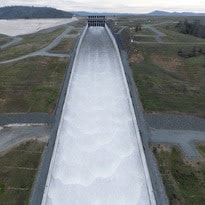 Main Spillway Releases Ongoing The Department of Water Resources (DWR) continues to perform flood protection releases from Lake Oroville using the main spillway and Hyatt Powerplant. Releases from Lake Oroville during the winter and spring months help maintain storage capacity in the reservoir for rain capture and future snowmelt. DWR coordinates releases closely with the U.S. Army Corps of Engineers and other water operators and adjusts releases as needed to account for continuing runoff. The information below reflects current reservoir level estimates. Forecasts can change quickly and may affect the estimates provided.
Crews may also be seen working near the main spillway for several weeks. Sections of the spillway’s underdrain system are being re-inspected to capture additional video footage. In addition, crews will be performing maintenance and repairs to the spillway’s lighting system. Lake Oroville is the largest storage facility in the State Water Project, providing flood protection while supporting environmental and water delivery needs to 27 million Californians. In 2023, Oroville Dam’s main spillway passed over 2,370,000 acre-feet of water, 67 percent of Lake Oroville’s capacity, with flows as high as 36,000 cfs. The main spillway continues to perform well and operate as designed. DWR continues to monitor lake levels, weather forecasts, and mountain snow levels to optimize water storage while meeting environmental requirements and allowing for carryover storage into next year.  EXPLORE TABLE MOUNTAIN Formed from ancient lava flows, the 3,300-acre North Table Mountain Ecological Reserve is a flat-topped mesa providing spectacular views of the valley below. Following winter rains, fissures along the vast lava caps form natural streams, vernal pools, and waterfalls that cascade off the plateau to the valley below. March is a spectacular time to enjoy miles of hiking trails through the reserve to view an array of wildflowers in bloom and an expansive carpet of green grasses. Cattle grazing on the reserve is used as a management tool to reduce thatch and non-native grass species to benefit native plants. More information about visiting the ecological reserve may be found on the California Department of Fish and Wildlife's (CDFW) website.  THERMALITO AFTERBAY PARTIAL CLOSURE FOR SPEED BOAT TIME TRIALS Speed boat time trials are returning to the Thermalito Afterbay March 16 to March 17. The event requires the closure of the southern portion of the Afterbay (south of Highway 162) and the Monument Hill boat ramp. The Larkin Road cartop boat launch will also be closed the afternoon of Friday, March 15 and will reopen Monday, March 18 in the morning. The Wilbur Road boat ramp and areas north of Hwy 162 will remain open for public use during the boating event. The event is hosted by the Northern California Outboard Association and East Bay Boat Club and will feature a mile-long course. Time trial events are expected Saturday and Sunday between 8 a.m. and 5 p.m. depending on weather and water conditions. More information about the event can be found on the American Power Boat Association webpage. 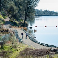 OROVILLE RECREATION
Trail users on the Brad Freeman Bike Trail that follows the old railroad grade between downtown Oroville and Hyatt Powerplant have long enjoyed the section of trail through the historic train tunnel. Unfortunately, wire theft and vandalism have rendered the train tunnel’s lighting system inoperable and beyond repair. DWR is designing an entirely new lighting system with construction anticipated in late 2024. The trail will remain open, but users are advised to bring their own light to navigate the train tunnel. DWR, the California Department of Parks and Recreation (State Parks), and CDFW maintain over 92 miles of trails in the Oroville area. An interactive map of recreation facilities, including open trails and their permitted uses (hike, bike, horse, multi), is available on DWR’s Lake Oroville Recreation webpage. A paper trail map is available at various locations, including most entrance kiosks and the Lake Oroville Visitor Center. The Lake Oroville Visitor Center is open daily from 9 a.m. to 5 p.m. Staffed by knowledgeable guides, the Visitor Center features interpretive displays on Oroville Dam, area geology, wildlife and habitat, hydroelectric power, and cultural and historical artifacts. View videos in the theater about the construction of Oroville Dam, walk or hike along nearby trails, and visit the 47-foot-tall observation tower that provides unsurpassed panoramic views of surrounding areas. Free guided tours for school and community groups are available by reservation. Parking and admission to the Visitor Center are free. Lake Oroville is one of the State Water Project’s premier recreational destinations and one of California’s best fishing spots. The lake provides both warm-water and cold-water fisheries and is a popular destination for bass tournaments. Below the Oroville Dam, the Thermalito Afterbay and the Feather River offer additional excellent fishing opportunities. The marinas at Bidwell Canyon and Lime Saddle are open daily and provide a variety of services including a convenience store, gas, and boat rentals. Upstream migrating fish totals between Jan. 1 and March 9 are:
CURRENT LAKE OPERATIONS Lake Oroville is at 863 feet elevation and storage is approximately 2.99 million acre-feet (MAF), which is 85 percent of its total capacity and 127 percent of the historical average. Feather River flows are at 1,600 cfs through the City of Oroville with 8,400 cfs being released from the Thermalito Afterbay River Outlet (Outlet) for a total Feather River release of 10,000 cfs downstream. Further changes to flows are planned over the weekend with the low-flow channel being reduced to 1,000 cfs and releases from the Thermalito Afterbay River Outlet being increased to 9,000 cfs by Sunday. DWR continues to assess releases to the Feather River daily. Visitors to Oroville Dam may also notice minor amounts of water flowing from drains built into the emergency spillway, which is normal and expected with the emergency spillway design. The dam and emergency spillway continue to operate as intended. The public can track precipitation, snow, reservoir levels, and more at the California Data Exchange Center. The Lake Oroville gage station is identified as “ORO.” All data as of midnight 3/14/2024. |
Archives
May 2024
Categories
All
|
 RSS Feed