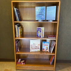
  New Hours for Visitor Center Starting Saturday, August 26, the Lake Oroville Visitor Center will now be open seven days a week from 9 a.m. to 5 p.m. Staffed by knowledgeable guides, the Visitor Center features interpretive displays on Oroville Dam, area geology, wildlife and habitat, hydroelectric power, and cultural and historical artifacts. View videos in the theater about the construction of Oroville Dam, walk or hike along nearby trails, and visit the 47-foot-tall observation tower that provides unsurpassed panoramic views of surrounding areas. Free guided tours for school and community groups are available by reservation. The Visitor Center also has a new, small library area featuring educational books for children on topics such as nature, the water cycle, science, and engineering. Parents, caregivers, and young children are encouraged to enjoy these books during their visit, with designated seating areas in the lobby or throughout the museum. Parking and admission to the Visitor Center are free. 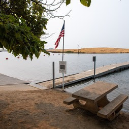 EXPLORE THE THERMALITO AFTERBAY The Thermalito Afterbay allows more extensive motorized watercraft use than the Thermalito Forebay and has a greater focus on the preservation and enhancement of wildlife habitat areas. With 17 miles of shoreline and 4,300 surface acres of water, the Thermalito Afterbay is open for boating, swimming, fishing, picnicking, and hunting. The Monument Hill boat ramp and day use area provides a two-lane ramp with a boarding dock, picnic tables, barbecues, restroom facilities, a fish cleaning station, and a swimming beach. The Wilbur Road boat ramp and Larkin Road Car-top boat ramp provide additional launching facilities for water recreation, with vault restroom facilities at both locations. Located within the Oroville Wildlife Area, campsites near the Afterbay Outlet offer primitive camping facilities with vault restrooms and trash receptacles. The Thermalito Afterbay outlet is one of the most popular river fishing areas, particularly during salmon runs. To check hunting and fishing seasons and regulations, consult the California Department of Fish and Wildlife. Several trails in the Afterbay area – Toland Road Trailhead, Tres Vias Trailhead, and East Hamilton Road Trailhead – connect with the popular Brad Freeman Trail for further exploration of the Oroville Wildlife Area. The East Hamilton Trailhead is the only facility with a picnic table and a small gravel parking area. 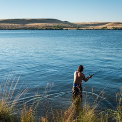 SPEND THE DAY AT THE THERMALITO FOREBAY The Thermalito Forebay provides a unique recreation experience compared to other geographic areas of the Lake Oroville State Recreation Area. Its relatively stable water elevation level, proximity to City of Oroville amenities, and developed day use facilities provide an experience that is much different from Lake Oroville. The North Thermalito Forebay boat ramp and day use area covers roughly half of the Forebay’s 630 surface acres and hosts non-motorized boating with a swim beach, a large picnic area with barbecue grills, and abundant shade trees. This area also has restroom facilities, including showers, and drinking fountains to stay hydrated during a heat wave. Also, at the North Forebay, the Feather River Center and Forebay Aquatic Center promote education, recreation, boating, water safety, competitive water sports, and tourism. The Aquatic Center offers a wide range of rental equipment, from kayaks and canoes, to hydrobikes and pedal boats, which can be rented by the hour or day. At the South Thermalito Forebay day use area, a two-lane boat ramp provides power boating access for recreation and fishing. The South Forebay also has a shaded picnic area with barbecue facilities, a sandy swim beach, a vault restroom facility, and a fish cleaning station. The Forebay shoreline also provides swimming opportunities to beat the heat. 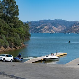 OROVILLE RECREATION
Visitors continue to enjoy the abundant recreation facilities at the Lake Oroville State Recreation Area. All major boat ramps are open with numerous launching lanes and available parking. Floating campsites provide a unique on-the-water camping experience, and several regular campgrounds provide camping throughout the Recreation Area while offering close access to water activities. The marinas at Bidwell Canyon and Lime Saddle are open daily and provide a variety of services including a convenience store, gas, and boat rentals. DWR, State Parks, and the California Department of Fish and Wildlife also maintain over 92 miles of trails in the Oroville area. An interactive map of recreation facilities, including open boat ramps, and their permitted uses (hike, bike, horse, multi) is available on DWR’s Lake Oroville Recreation webpage. A paper trail map is available at various locations, including most entrance kiosks and the Visitor Center. CURRENT LAKE OPERATIONS Lake Oroville is at 860 feet elevation and storage is approximately 2.95 million acre-feet (MAF), which is 83 percent of its total capacity and 139 percent of the historical average. Feather River releases are currently at 6,000 cubic feet per second (cfs). Flows through the City of Oroville are at 650 cfs and releases from the Thermalito Afterbay Outlet (Outlet) are at 5,350 cfs for a total of 6,000 cfs downstream of the Outlet. Further changes in total releases may occur next week for Delta water quality purposes. DWR continues to assess releases to the Feather River daily. DWR has been using the main spillway intermittently this summer for water releases to manage storage within the Oroville complex or maintain Feather River temperature levels during ongoing river valve outlet system work near the Hyatt Powerplant. When the main spillway is not in use, water may still be seen on the main spillway outlet as the seals on the eight radial gates are not designed to be watertight. The gate seals do not play a role in the structural integrity of the gates, which continue to operate as intended. DWR periodically maintains and adjusts the seals during low-reservoir conditions to improve their sealing capability. The radial gates were last inspected and tested in Dec. 2022. Visitors to Oroville Dam may also notice minor amounts of water flowing from drains built into the emergency spillway, which is normal and expected with the emergency spillway design. The dam and emergency spillway continue to operate as intended. The public can track precipitation, snow, reservoir levels, and more at the California Data Exchange Center. The Lake Oroville gage station is identified as “ORO.” All data as of midnight 8/24/2023. 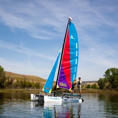 Spend the Day at the Thermalito Forebay The Thermalito Forebay provides a unique recreation experience compared to other geographic areas of the Lake Oroville State Recreation Area. Its relatively stable water elevation level, proximity to City of Oroville amenities, and developed day use facilities provide an experience that is much different from Lake Oroville. The North Thermalito Forebay boat ramp and day use area covers roughly half of the Forebay’s 630 surface acres and hosts non-motorized boating with a swim beach, large picnic area with barbecue grills, and abundant shade trees. This area also has restroom facilities, including showers, and drinking fountains to stay hydrated during a heat wave. Also at the North Forebay, the Feather River Center and Forebay Aquatic Center promote education, recreation, boating, water safety, competitive water sports, and tourism. The Aquatic Center offers a wide range of rental equipment, from kayaks and canoes, to hydrobikes and pedal boats, which can be rented by the hour or day. At the South Thermalito Forebay day use area, a two-lane boat ramp provides power boating access for recreation and fishing. The South Forebay also has a shaded picnic area with barbecue facilities and sandy swim beach, a vault restroom facility, and fish cleaning station. The Forebay shoreline also provides swimming opportunities to combat the heat. 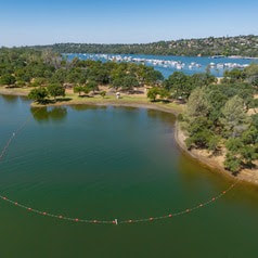 EXPLORE LOAFER CREEK Located along the southern shoreline of Lake Oroville, the Loafer Creek Recreation Area offers several hiking, equestrian, and biking trails that are largely shaded by trees. With current temperatures in the high-90 or 100-plus degree range, trails such as the Loafer Creek Day Use (1.7 miles) or Loafer Creek Loop (4.1 miles) offer a shaded respite from the scorching sun. Trails also run along Lake Oroville’s waterline, providing an opportunity to cool off in the lake after meeting your activity goals for the day. The Loafer Creek recreation trails can be accessed from the Loafer Point Campground and Day-Use area off Highway 162 (Oro-Quincy Highway), or trail users can connect to Loafer Creek through the Bidwell Canyon Saddle Dam Trail. The trails are open to equestrians and cyclists, but cyclists must stay on paved and dirt roads. 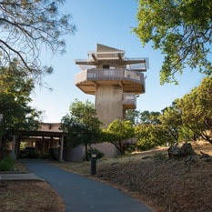 OROVILLE RECREATION
The Lake Oroville Visitor Center is open Monday through Friday between 9 a.m. and 5 p.m. The Visitor Center offers numerous educational exhibits, a theater featuring videos about the building of Oroville Dam, walking and hiking trails, and a 47-foot-tall observation tower providing unsurpassed panoramic views. Visitors continue to enjoy the abundant recreation facilities at the Lake Oroville State Recreation Area. All major boat ramps are open with numerous launching lanes and available parking. Floating campsites provide a unique on-the-water camping experience, and several regular campgrounds provide camping throughout the Recreation Area while offering close access to water activities. The marinas at Bidwell Canyon and Lime Saddle are open daily and provide a variety of services including a convenience store, gas, and boat rentals. The North Forebay Aquatic Center has several summertime programs, and the Thermalito Afterbay has been a popular recreation spot for water skiers, jet skiers, paddle boarders, and anglers. DWR, State Parks, and the California Department of Fish and Wildlife also maintain over 92 miles of trails in the Oroville area. An interactive map of recreation facilities, including open boat ramps, and their permitted uses (hike, bike, horse, multi) is available on DWR’s Lake Oroville Recreation webpage. A paper trail map is available at various locations, including most entrance kiosks and the Visitor Center. CURRENT LAKE OPERATIONS Lake Oroville is at 865 feet elevation and storage is approximately 3.01 million acre-feet (MAF), which is 85 percent of its total capacity and 138 percent of the historical average. Feather River releases are currently at 4,500 cfs. Flows through the City of Oroville are at 2,200 cfs with further reductions scheduled into next week. Releases from the Thermalito Afterbay Outlet (Outlet) are at 2,300 cfs with further increases scheduled for a total of 4,500 cfs downstream of the Outlet. Further changes in flow through the City of Oroville may occur next week for Delta water quality purposes. DWR continues to assess releases to the Feather River daily. DWR has been using the main spillway intermittently this summer for water releases to manage storage within the Oroville complex or maintain Feather River temperature levels during ongoing river valve outlet system work near the Hyatt Powerplant. When the main spillway is not in use, water may still be seen on the main spillway outlet as the seals on the eight radial gates are not designed to be watertight. The gate seals do not play a role in the structural integrity of the gates, which continue to operate as intended. DWR periodically maintains and adjusts the seals during low-reservoir conditions to improve their sealing capability. The radial gates were also last inspected and tested in Dec. 2022. Visitors to Oroville Dam may also notice minor amounts of water flowing from drains built into the emergency spillway, which is normal and expected with the emergency spillway design. The dam and emergency spillway continue to operate as intended. The public can track precipitation, snow, reservoir levels, and more at the California Data Exchange Center. The Lake Oroville gage station is identified as “ORO”. All data as of midnight 8/17/2023.  Explore Loafer Creek Located along the southern shoreline of Lake Oroville, the Loafer Creek Recreation Area offers several hiking, equestrian, and biking trails that are largely shaded by trees. With current temperatures in the high 90 or 100-plus degree range, trails such as the Loafer Creek Day Use (1.7 miles) or Loafer Creek Loop (4.1 miles) offer a shaded respite from the scorching sun. Trails also run along Lake Oroville’s waterline, providing an opportunity to cool off in the lake after meeting your activity goals for the day. The Loafer Creek recreation trails can be accessed from the Loafer Point Campground and Day-Use area off Highway 162 (Oro-Quincy Highway) or trail users can connect to Loafer Creek through the Bidwell Canyon Saddle Dam Trail. The trails are open to equestrians and cyclists, but cyclists must stay on paved and graveled roads. 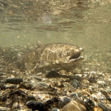 SALMON HABITAT PROJECT The Department of Water Resources (DWR) is continuing construction on a salmonid habitat improvement project in the Feather River near the Feather River Fish Hatchery and Bedrock Park in Oroville. In development since 2021, the project consists of in-river spawning gravel placement to improve existing spawning habitat sites and will also improve habitat accessibility to existing side channels by excavating and redistributing accumulated streambed material. Migratory fish species such as Chinook salmon and steelhead trout rely on Feather River spawning habitats along the low-flow channel, where most spawning activity occurs. Female salmonids lay their eggs in nests called “redds” using coarse sediment, such as clean, rounded gravel. During construction, people floating down the Feather River in this area may encounter “traffic control” along the waterway. Construction flaggers with stop signs will be stationed in the river to alert water users of nearby heavy construction equipment and direct water traffic safely through the construction zone. River recreationists are encouraged to remain alert when passing through work zones. DWR’s project is placing approximately 8,000 cubic yards of gravel at multiple locations to improve spawning conditions. The project is primarily funded by two grants: the State of California Natural Resource Agency Prop 68 – Protecting California’s Rivers, Streams and Watershed Grant Program, and the Central Valley Project Improvement Act – Fish and Wildlife Restoration Activities supported by the U.S. Department of Interior. Previous DWR Feather River spawning restoration projects included the placement of 8,300 cubic yards of spawning gravel in 2014 and another 5,000 cubic yards in 2017. In-river work for the project is expected to last through the end of August. 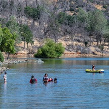 OROVILLE RECREATION
Visitors continue to enjoy the abundant recreation facilities at the Lake Oroville State Recreation Area. All major boat ramps are open with numerous launching lanes and available parking. Floating campsite reservations remain popular with campgrounds throughout the Recreation Area also offering close access for water activities. The marinas at Bidwell Canyon and Lime Saddle are open daily and provide a variety of services including a convenience store, gas, and boat rentals. The North Forebay Aquatic Center has several summertime programs, and the Thermalito Afterbay has been a popular recreation spot for water skiers, jet skiers, and anglers. The Lake Oroville Visitor Center is open Monday through Friday between 9 a.m. and 5 p.m. The Visitor Center offers numerous educational exhibits, a theater featuring videos about the building of Oroville Dam, walking and hiking trails, and a 47-foot-tall observation tower providing unsurpassed panoramic views. DWR, State Parks, and the California Department of Fish and Wildlife also maintain over 92 miles of trails in the Oroville area. An interactive map of recreation facilities, including open boat ramps, and their permitted uses (hike, bike, horse, multi) is available on DWR’s Lake Oroville Recreation webpage. A paper trail map is available at various locations, including most entrance kiosks and the Visitor Center. CURRENT LAKE OPERATIONS Lake Oroville is at 870 feet elevation and storage is approximately 3.09 million acre-feet (MAF), which is 87 percent of its total capacity and 137 percent of the historical average. Feather River releases are currently at 6,000 cfs. Flows through the City of Oroville were increased to 5,000 cfs today and releases from the Thermalito Afterbay Outlet (Outlet) were decreased to 1,000 cfs for a total of 6,000 cfs downstream of the Outlet. Further changes in flow through the City of Oroville may occur next week for fisheries purposes. DWR continues to assess releases to the Feather River daily. DWR will use the main spillway intermittently this summer for water releases to manage storage within the Oroville complex or maintain Feather River temperature levels during ongoing river valve outlet system work near the Hyatt Powerplant. When the main spillway is not in use, water may still be seen on the main spillway outlet as the seals on the eight radial gates are not designed to be watertight. The gate seals do not play a role in the structural integrity of the gates, which continue to operate as intended. DWR periodically maintains and adjusts the seals during low-reservoir conditions to improve their sealing capability. The radial gates were also last inspected and tested in Dec. 2022. Visitors to Oroville Dam may also notice minor amounts of water flowing from drains built into the emergency spillway. As the reservoir level has increased, water flow from the drains has increased, which is normal and expected with the emergency spillway design. The dam and emergency spillway continue to operate as intended. The public can track precipitation, snow, reservoir levels, and more at the California Data Exchange Center. The Lake Oroville gage station is identified as “ORO”. All data as of midnight 8/10/2023. 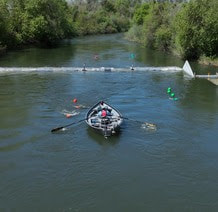 Feather River Fish Monitoring Station DWR has completed the installation of a fish monitoring station in the Feather River about five miles downstream of Oroville. The fish monitoring structure guides fish past an underwater video camera that allows biologists to review footage and determine abundance, run timing, and origin (hatchery or natural) of steelhead and Chinook salmon populations. This information will improve management of these important fish populations in the Feather River and at the Feather River Fish Hatchery. There are several of these structures already operating in rivers throughout California and they are designed to facilitate safe boat passage. Informational signs will be posted at boat launches and near the monitoring station to assist river users in navigating over the structure. Those in more portable water vessels also have the option to use the riverbank and walk around the monitoring station. The fish monitoring station is located approximately 6.5 miles downstream of the Feather River Fish Hatchery, 4.5 miles downstream of the Riverbend Park Boat Ramp, and 1.5 miles upstream of the Thermalito Afterbay River Outlet Boat Ramp.  SALMON HABITAT PROJECT DWR began construction this week on a salmonid habitat improvement project in the Feather River near the Feather River Fish Hatchery and Bedrock Park in Oroville. In development since 2021, the project consists of in-river spawning gravel placement to improve existing spawning habitat sites and will also improve habitat accessibility to existing side channels by excavating and redistributing accumulated streambed material. Migratory fish species such as Chinook salmon and steelhead trout rely on Feather River spawning habitats along the low-flow channel, where most spawning activity occurs. Female salmonids lay their eggs in nests called “redds” using coarse sediment, such as clean, rounded gravel. Starting Monday, Aug. 7, people floating down the Feather River in this area may encounter “traffic control” along the waterway. Construction flaggers with stop signs will be stationed in the river to alert water users of nearby heavy construction equipment and direct water traffic safely through the construction zone. River recreationists are encouraged to remain alert when passing through work zones. DWR’s project is placing approximately 8,000 cubic yards of gravel at multiple locations to improve spawning conditions. The project is primarily funded by two grants: the State of California Natural Resource Agency Prop 68 – Protecting California’s Rivers, Streams and Watershed Grant Program, and the Central Valley Project Improvement Act – Fish and Wildlife Restoration Activities supported by the U.S. Department of Interior. Previous DWR Feather River spawning restoration projects included the placement of 8,300 cubic yards of spawning gravel in 2014 and another 5,000 cubic yards in 2017. In-river work for the project is expected to last through the end of August. 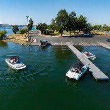 OROVILLE RECREATION
Visitors continue to enjoy the abundant recreation facilities at the Lake Oroville State Recreation Area. All major boat ramps are open and, with numerous launching lanes and available parking, wait times are at a minimum. Floating campsite reservations remain popular with campgrounds throughout the Recreation Area also offering close access for water activities. The marinas at Bidwell Canyon and Lime Saddle are open daily and provide a variety of services including a convenience store, gas, and boat rentals. The North Forebay Aquatic Center has several summertime programs, and the Thermalito Afterbay has been a popular recreation spot for water skiers, jet skiers, and anglers. The Lake Oroville Visitor Center is open Monday through Friday between 9 a.m. and 5 p.m. The Visitor Center offers numerous educational exhibits, a theater featuring videos about the building of Oroville Dam, walking and hiking trails, and a 47-foot-tall observation tower providing unsurpassed panoramic views. DWR, State Parks, and the California Department of Fish and Wildlife also maintain over 92 miles of trails in the Oroville area. An interactive map of recreation facilities, including open boat ramps, and their permitted uses (hike, bike, horse, multi) is available on DWR’s Lake Oroville Recreation webpage. A paper trail map is available at various locations, including most entrance kiosks and the Visitor Center. CURRENT LAKE OPERATIONS Lake Oroville is at 877 feet elevation and storage is approximately 3.19 million acre-feet (MAF), which is 90 percent of its total capacity and 137 percent of the historical average. Feather River releases are currently at 6,500 cfs. Flows through the City of Oroville are at 2,000 cfs and releases from the Thermalito Afterbay Outlet (Outlet) are at 4,500 cfs for a total of 6,500 cfs downstream of the Outlet. Further increases in flow through the City of Oroville are expected next week for fisheries purposes. DWR continues to assess releases to the Feather River daily. DWR will use the main spillway intermittently this summer for water releases to manage storage within the Oroville complex or maintain Feather River temperature levels during ongoing river valve outlet system work near the Hyatt Powerplant. When the main spillway is not in use, water may still be seen on the main spillway outlet as the seals on the eight radial gates are not designed to be watertight. The gate seals do not play a role in the structural integrity of the gates, which continue to operate as intended. DWR periodically maintains and adjusts the seals during low-reservoir conditions to improve their sealing capability. The radial gates were also last inspected and tested in Dec. 2022. Visitors to Oroville Dam may also notice minor amounts of water flowing from drains built into the emergency spillway. As the reservoir level has increased, water flow from the drains has increased, which is normal and expected with the emergency spillway design. The dam and emergency spillway continue to operate as intended. The public can track precipitation, snow, reservoir levels, and more at the California Data Exchange Center. The Lake Oroville gage station is identified as “ORO”. All data as of midnight 8/3/2023. |
Archives
May 2024
Categories
All
|
 RSS Feed