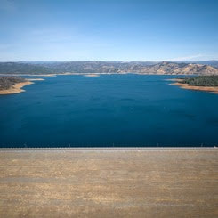
 Oroville Dam Citizens Advisory Commission The California Natural Resources Agency hosted a virtual Oroville Dam Citizens Advisory Commission meeting on Nov. 15 via Zoom. In addition to public comment, the Commission received briefings on Forecast Informed Reservoir Operations, the U.S. Army Corps of Engineers’ process to update the Water Control Manual for Oroville operations, and preparations for 2023–24 winter operations. The Citizens Advisory Commission is a forum for questions and feedback from the communities surrounding Oroville Dam. For information on the meeting, please visit https://bit.ly/OrovilleCAC. A transcript of the meeting will be available on the webpage in the coming weeks. 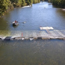 FEATHER RIVER FISH MONITORING STATION A Feather River Fish Monitoring Station installed by the Department of Water Resources (DWR) in Oroville continues to provide underwater video footage that allows biologists to determine abundance, run timing, and origin (hatchery or natural) of steelhead and Chinook salmon populations. This information helps improve management of these important fish populations in the Feather River and at the Feather River Fish Hatchery. Monitoring stations like this are widely used in many rivers to collect fish population data and provide a safer and faster method of data collection, while still permitting river recreation. Whether traveling downstream or upstream, vessels of all kinds can safely navigate over the structure. DWR’s instructional video illustrates how vessels such as powerboats, drift boats, and kayaks may navigate over the fish monitoring station. Those in more portable water vessels also have the option to use the riverbank and walk around the monitoring station. Upstream migrating fish totals between Sept. 11 and Nov. 11 are:
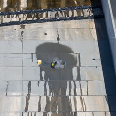 MAINTENANCE WORK ON MAIN SPILLWAY EXTENDED Routine concrete and joint sealant repair work on localized areas of Oroville Dam’s main spillway has been extended to Dec. 1 due to favorable weather and lower reservoir levels. DWR will continue to monitor reservoir levels and weather forecasts closely and will end repair work for this season early if spillway releases are required for flood control. Oroville Dam’s main spillway performed well and operated as designed in 2023, passing over 2,370,000 acre-feet of water – approximately 67 percent of the capacity of Lake Oroville. Due to seasonal temperature variations, spillway releases, and sun exposure, periodic concrete and joint sealant repairs of the main spillway are expected. Work so far has included concrete repair, approximately 1,700 feet of concrete slab and wall joint sealant replacement, and inspection of the 51,000 feet of piping that support the spillway’s improved drainage system. The spillway was rebuilt to the highest engineering and safety standards with oversight and guidance by the Federal Energy Regulatory Commission (FERC), Division of Safety of Dams (DSOD), and an independent board of consultants. DWR performed a significant amount of inspection and testing throughout construction to verify compliance with project specifications. DWR also provides regular updates to the Oroville Dam Citizens Advisory Commission. 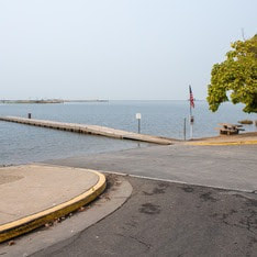 OROVILLE RECREATION The Monument Hill Boat Ramp at the Thermalito Afterbay will be closed for repairs on Monday, Nov. 20. Trailered boat launch access to the Afterbay will still be available at the Wilbur Road boat ramp, while access for cartop boaters is available at the Larkin Road ramp. The Lake Oroville Visitor Center is open seven days a week from 9 a.m. to 5 p.m. Staffed by knowledgeable guides, the Visitor Center features interpretive displays on Oroville Dam, area geology, wildlife and habitat, hydroelectric power, and cultural and historical artifacts. View videos in the theater about the construction of Oroville Dam, walk or hike along nearby trails, and visit the 47-foot-tall observation tower that provides unsurpassed panoramic views of surrounding areas. Free guided tours for school and community groups are available by reservation. Parking and admission to the Visitor Center are free. DWR, State Parks, and the Department of Fish and Wildlife maintain over 92 miles of trails in the Oroville area. An interactive map of recreation facilities, including open trails and their permitted uses (hike, bike, horse, multi), is available on DWR’s Lake Oroville Recreation webpage. A paper trail map is available at various locations, including most entrance kiosks and the Lake Oroville Visitor Center. The marinas at Bidwell Canyon and Lime Saddle are open daily and provide a variety of services including a convenience store, gas, and boat rentals. CURRENT LAKE OPERATIONS Lake Oroville is at 814 feet elevation and storage is approximately 2.36 million acre-feet (MAF), which is 67 percent of its total capacity and 132 percent of the historical average. Feather River flows remain at 650 cubic feet per second (cfs) through the City of Oroville with 1,100 cfs being released from the Thermalito Afterbay River Outlet (Outlet) for a total Feather River release of 1,750 cfs downstream. DWR continues to assess releases to the Feather River daily. Visitors to Oroville Dam may also notice minor amounts of water flowing from drains built into the emergency spillway, which is normal and expected with the emergency spillway design. The dam and emergency spillway continue to operate as intended. The public can track precipitation, snow, reservoir levels, and more at the California Data Exchange Center. The Lake Oroville gage station is identified as “ORO.” All data as of midnight 11/16/2023. DWR wishes everyone a Happy Thanksgiving. The Lake Oroville Community Update will return on December 1, 2023. 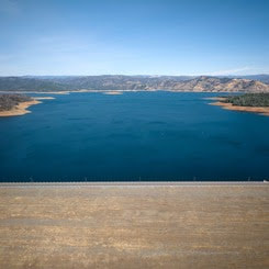 Oroville Dam Citizens Advisory Commission The California Natural Resources Agency is hosting its 15th Oroville Dam Citizens Advisory Commission meeting on Wednesday, Nov. 15 from 10 a.m. to noon. The public meeting will be held virtually and will include presentations and public comment. The Commission will receive briefings on Forecast Informed Reservoir Operations, the U.S. Army Corps of Engineers’ process to update the Water Control Manual for Oroville operations, and preparations for 2023–24 winter operations. The Citizens Advisory Commission is a forum for questions and feedback from the communities surrounding Oroville Dam. For information on how to join the virtual meeting, please visit the Oroville Dam Citizens Advisory Commission website. 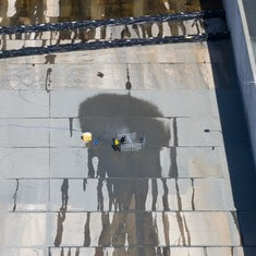 MAINTENANCE WORK ON MAIN SPILLWAY EXTENDED Routine concrete and joint sealant repair work on localized areas of Oroville Dam’s main spillway has been extended to Dec. 1 due to favorable weather and lower reservoir levels. DWR will continue to monitor reservoir levels and weather forecasts closely and will end repair work for this season early if spillway releases are required for flood control. Oroville Dam’s main spillway performed well and operated as designed in 2023, passing over 2,370,000 acre-feet of water – approximately 67 percent of the capacity of Lake Oroville. Due to seasonal temperature variations, spillway releases, and sun exposure, periodic concrete and joint sealant repairs of the main spillway are expected. Work so far has included concrete repair, approximately 1,700 feet of concrete slab and wall joint sealant replacement, and inspection of the 51,000 feet of piping that support the spillway’s improved drainage system. The spillway was rebuilt to the highest engineering and safety standards with oversight and guidance by the Federal Energy Regulatory Commission (FERC), Division of Safety of Dams (DSOD), and an independent board of consultants. DWR performed a significant amount of inspection and testing throughout construction to verify compliance with project specifications. DWR also provides regular updates to the Oroville Dam Citizens Advisory Commission, a public forum for discussing operations, maintenance, and public safety activities at Oroville Dam and its facilities. 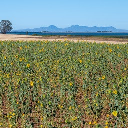 OROVILLE WILDLIFE AREA The 11,800-acre Oroville Wildlife Area (OWA) is a forested upland and riparian habitat along the Feather River and around the Thermalito Afterbay. Managed by the California Department of Fish and Wildlife, in partnership with DWR, the OWA allows for additional outdoor recreation activities such as hunting, river- and pond-oriented fishing and boating, and wildlife observation and photography. Several trails cross throughout the OWA, providing opportunities for hiking and biking. Other trails within the OWA are not officially designated and none are ADA accessible. The Feather River runs through the center of the OWA and several locations provide unpaved boat ramp access. Both car-top and trailer launching occur at many of these ramps. A restroom is available at the day use/camping area adjacent to the Thermalito Afterbay River Outlet area. The OWA is a “Type C” wildlife area (hunting pass not required) and is open for hunting seven days a week with entry hours limited from 1.5 hours before sunrise to one hour after sunset. No rifles or pistols may be used or possessed on the wildlife area except at the designated shooting range (Rabe Rd. Shooting Range off Larkin Rd.; open seven days a week from sunrise to sunset). Lead ammunition cannot be used while hunting in California. 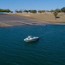 OROVILLE RECREATION DWR biologists are using the Feather River Fish Monitoring Station to determine abundance, run timing, and origin (hatchery or natural) of steelhead and Chinook salmon populations. This information will improve the management of these important fish populations. Upstream migrating fish totals between Sept. 11 and Oct. 28 are:
The Lake Oroville Visitor Center is open seven days a week from 9 a.m. to 5 p.m. Staffed by knowledgeable guides, the Visitor Center features interpretive displays on Oroville Dam, area geology, wildlife and habitat, hydroelectric power, and cultural and historical artifacts. View videos in the theater about the construction of Oroville Dam, walk or hike along nearby trails, and visit the 47-foot-tall observation tower that provides unsurpassed panoramic views of surrounding areas. Free guided tours for school and community groups are available by reservation. Parking and admission to the Visitor Center are free. CURRENT LAKE OPERATIONS Lake Oroville is at 817 feet elevation and storage is approximately 2.39 million acre-feet (MAF), which is 68 percent of its total capacity and 133 percent of the historical average. Feather River flows remain at 650 cubic feet per second (cfs) through the City of Oroville with 1,100 cfs being released from the Thermalito Afterbay River Outlet (Outlet) for a total Feather River release of 1,750 cfs downstream. DWR continues to assess releases to the Feather River daily. Visitors to Oroville Dam may also notice minor amounts of water flowing from drains built into the emergency spillway, which is normal and expected with the emergency spillway design. The dam and emergency spillway continue to operate as intended. The public can track precipitation, snow, reservoir levels, and more at the California Data Exchange Center. The Lake Oroville gage station is identified as “ORO.” All data as of midnight 11/8/2023.  Oroville Recreation Advisory Committee The Oroville Recreation Advisory Committee (ORAC) met Nov. 3 at the Southside Oroville Community Center. ORAC was established by the Federal Energy Regulatory Commission (FERC) to review and provide recreation plan recommendations for Oroville Facilities owned by the Department of Water Resources (DWR). The 13-member committee is made up of representatives from state and local government, recreation groups, and business and community organizations. To obtain a summary of the meeting, send a request to [email protected].  OROVILLE WILDLIFE AREA The 11,800-acre Oroville Wildlife Area (OWA) is a forested upland and riparian habitat along the Feather River and around the Thermalito Afterbay. Managed by the California Department of Fish and Wildlife, in partnership with DWR, the OWA allows for additional outdoor recreation activities such as hunting, river- and pond-oriented fishing and boating, and wildlife observation and photography. Several trails cross throughout the OWA, providing opportunities for hiking and biking. Other trails within the OWA are not officially designated and none are ADA accessible. The Feather River runs through the center of the OWA and has several channels with unpaved boat ramp access. Both car-top and trailer launching occur at many of these ramps. In addition, the Thermalito Afterbay River Outlet boat ramp is located within the OWA boundary and contains gravel and a concrete block mat. A restroom is available at the adjacent day use/camping area. The OWA is a “Type C” wildlife area (hunting pass not required) and is open for hunting seven days a week with entry hours limited from 1.5 hours before sunrise to one hour after sunset. No rifles or pistols may be used or possessed on the wildlife area except at the designated shooting range (Rabe Rd. Shooting Range off Larkin Rd.; open seven days a week from sunrise to sunset). Lead ammunition cannot be used while hunting in California. 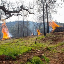 VEGETATION MANAGEMENT ACTIVITIES DWR has been awarded Hazard Mitigation Grant Program (HMGP) funds totaling $900,000 from the Federal Emergency Management Agency (FEMA) to complete a 305-acre hazardous fuels reduction project in the Lake Oroville area. Fuel reduction locations include DWR property along Oro Dam Blvd. East, the Bidwell Canyon/Kelly Ridge area, and the Loafer Creek State Recreation Area. This multi-year project will reduce hazardous fuels by thinning vegetation using hand and mechanical methods accompanied by chipping. This project reduces the risk of a catastrophic wildfire by improving defensible space around infrastructure, roads, and residential areas. By proactively reducing ground fuels, thinning overgrown vegetation, and removing dead and dying vegetation, firefighters have a better chance at suppressing wildfires. HMGP work began last week and will continue over the next three years. This work may cause intermittent trail closures within project areas. Recreational trail users should be cautious when entering work areas and obey all posted trail signage. In addition to HMGP activities, DWR and CAL FIRE have resumed vegetation management activities in the Loafer Creek Recreation Area. CAL FIRE hand crews and heavy equipment operators are currently performing prescribed burns throughout Loafer Creek and along HWY 162 (Oro Quincy Highway). Smoke from pile burning activities will be visible in the Oroville area for the next several months. DWR’s Fuel Load Management Plan works to reduce wildfire risk, increase public safety, and enhance forest health around the Lake Oroville area. Ongoing vegetation management of this critical area remains a high priority for DWR and its partners at CAL FIRE, Butte County Fire Department, Butte County Sheriff’s Office, California Conservation Corps (CCC), California Department of Parks and Recreation (State Parks), and the Butte County Fire Safe Council.  OROVILLE RECREATION DWR biologists are using the Feather River Fish Monitoring Station to determine abundance, run timing, and origin (hatchery or natural) of steelhead and Chinook salmon populations. This information will improve the management of these important fish populations. Upstream migrating fish totals between Sept. 11 and Oct. 21 are:
The Lake Oroville Visitor Center is open seven days a week from 9 a.m. to 5 p.m. Staffed by knowledgeable guides, the Visitor Center features interpretive displays on Oroville Dam, area geology, wildlife and habitat, hydroelectric power, and cultural and historical artifacts. View videos in the theater about the construction of Oroville Dam, walk or hike along nearby trails, and visit the 47-foot-tall observation tower that provides unsurpassed panoramic views of surrounding areas. Free guided tours for school and community groups are available by reservation. Parking and admission to the Visitor Center are free. CURRENT LAKE OPERATIONS Lake Oroville is at 819 feet elevation and storage is approximately 2.42 million acre-feet (MAF), which is 68 percent of its total capacity and 134 percent of the historical average. Feather River flows remain at 650 cubic feet per second (cfs) through the City of Oroville with 1,100 cfs being released from the Thermalito Afterbay River Outlet (Outlet) for a total Feather River release of 1,750 cfs downstream. DWR continues to assess releases to the Feather River daily. Visitors to Oroville Dam may also notice minor amounts of water flowing from drains built into the emergency spillway, which is normal and expected with the emergency spillway design. The dam and emergency spillway continue to operate as intended. The public can track precipitation, snow, reservoir levels, and more at the California Data Exchange Center. The Lake Oroville gage station is identified as “ORO.” All data as of midnight 11/2/2023. |
Archives
May 2024
Categories
All
|


 RSS Feed