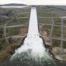
  Main Spillway Releases Ongoing The Department of Water Resources (DWR) continues to perform flood protection releases from Lake Oroville using the main spillway and Hyatt Powerplant. Releases from Lake Oroville during the winter and spring months help maintain storage capacity in the reservoir for rain capture and future snowmelt. DWR coordinates releases closely with the U.S. Army Corps of Engineers and other water operators and adjusts releases as needed to account for continuing runoff. The information below reflects current reservoir level estimates. Forecasts can change quickly and may affect the estimates provided.
Crews may also be seen working near the main spillway for several weeks. Sections of the spillway’s underdrain system are being re-inspected to capture additional video footage. In addition, crews will be performing maintenance and repairs to the spillway’s lighting system. Lake Oroville is the largest storage facility in the State Water Project, providing flood protection while supporting environmental and water delivery needs to 27 million Californians. In 2023, Oroville Dam’s main spillway passed over 2,370,000 acre-feet of water, 67 percent of Lake Oroville’s capacity, with flows as high as 36,000 cfs. The main spillway continues to perform well and operate as designed. DWR continues to monitor lake levels, weather forecasts, and mountain snow levels to optimize water storage while meeting environmental requirements and allowing for carryover storage into next year. 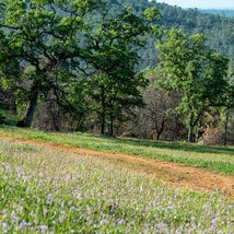 TEMPORARY TRAIL CLOSURE IN POTTER’S RAVINE AREA DWR and the California Department of Parks and Recreation (State Parks) have temporarily closed a section of Dead Cow Ravine Trail in the Potter’s Ravine area at the Lake Oroville State Recreation Area. Recreation users can still access the north section of Dead Cow Ravine Trail to Gobbler’s Knob from the Potter’s Point trail. The trail is anticipated to remain closed and be considered an environmentally sensitive area through July 31, 2024. Additionally, wire theft and vandalism have rendered the lighting system within the Brad Freeman Bike Trail’s historic train tunnel inoperable and beyond repair. DWR is designing an entirely new lighting system with construction anticipated in late 2024. The trail will remain open, but users are advised to bring their own light to navigate the train tunnel. DWR, State Parks, and the California Department of Fish and Wildlife (CDFW) maintain over 92 miles of trails in the Oroville area. An interactive map of recreation facilities, including open trails and their permitted uses (hike, bike, horse, multi), is available on DWR’s Lake Oroville Recreation webpage. A paper trail map is available at various locations, including most entrance kiosks and the Lake Oroville Visitor Center. 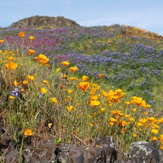 EXPLORE TABLE MOUNTAIN Formed from ancient lava flows, the 3,300-acre North Table Mountain Ecological Reserve is a flat-topped mesa providing spectacular views of the valley below. Following winter rains, fissures along the vast lava caps form natural streams, vernal pools, and waterfalls that cascade off the plateau to the valley below. March is a spectacular time to enjoy miles of hiking trails through the reserve to view an array of wildflowers in bloom and an expansive carpet of green grasses. Cattle grazing on the reserve is used as a management tool to reduce thatch and non-native grass species to benefit native plants. More information about visiting the ecological reserve may be found on the California Department of Fish and Wildlife's (CDFW) website. 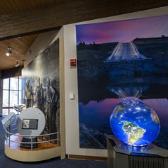 OROVILLE RECREATION
The Lake Oroville Visitor Center is open daily from 9 a.m. to 5 p.m. Staffed by knowledgeable guides, the Visitor Center features interpretive displays on Oroville Dam, area geology, wildlife and habitat, hydroelectric power, and cultural and historical artifacts. View videos in the theater about the construction of Oroville Dam, walk or hike along nearby trails, and visit the 47-foot-tall observation tower that provides unsurpassed panoramic views of surrounding areas. Free guided tours for school and community groups are available by reservation. Parking and admission to the Visitor Center are free. Lake Oroville is one of the State Water Project’s premier recreational destinations and one of California’s best fishing spots. The lake provides both warm-water and cold-water fisheries and is a popular destination for bass tournaments. Below the Oroville Dam, the Thermalito Afterbay and the Feather River offer additional excellent fishing opportunities. The marinas at Bidwell Canyon and Lime Saddle are open daily and provide a variety of services including a convenience store, gas, and boat rentals. Upstream migrating fish totals between Jan. 1 and March 9 are:
CURRENT LAKE OPERATIONS Lake Oroville is at 866 feet elevation and storage is approximately 3.03 million acre-feet (MAF), which is 86 percent of its total capacity and 125 percent of the historical average. Feather River flows are at 1,000 cfs through the City of Oroville with 9,000 cfs being released from the Thermalito Afterbay River Outlet (Outlet) for a total Feather River release of 10,000 cfs downstream. Releases may be adjusted over the weekend or early next week to account for storm impacts and higher inflows into Lake Oroville. DWR continues to assess releases to the Feather River daily. Visitors to Oroville Dam may also notice minor amounts of water flowing from drains built into the emergency spillway, which is normal and expected with the emergency spillway design. The dam and emergency spillway continue to operate as intended. The public can track precipitation, snow, reservoir levels, and more at the California Data Exchange Center. The Lake Oroville gage station is identified as “ORO.” All data as of midnight 3/21/2024. Comments are closed.
|
Archives
May 2024
Categories
All
|
 RSS Feed