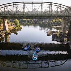
  Feather River Floating Classrooms Spend time on the beautiful Feather River this fall and join Department of Water Resources (DWR) scientists for educational floats each Saturday through Nov. 11. Rafting trips will float through Feather River spawning habitat while DWR scientists provide information on Chinook salmon conservation efforts, ongoing and planned research, and restoration and monitoring projects. Each Saturday will have three floating classroom sessions with limited seats. Weekend sessions support free floating classroom events for local schools. Reserve your Floating Classroom Tour Tickets on Eventbrite. 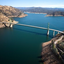 CALIFORNIA PREPARES FOR A POSSIBLE WET EL NIÑO YEAR DWR and its federal and local partners are preparing for the new water year, which started Oct. 1, and the possibility of another wet season under strong El Niño conditions. DWR will utilize the most advanced forecasting tools with our partners at the National Oceanic and Atmospheric Administration (NOAA), the Scripps Institution of Oceanography, and others to prepare for whatever may come to California in the months ahead. DWR and the U.S. Bureau of Reclamation, which operate the State Water Project and Central Valley Project respectively, are closely coordinating to ensure the state’s reservoirs have flood protection space available while storing as much water as possible in case drought conditions return. This past winter’s storms provided a huge boost to the State Water Project (SWP), which captured a total of 3.5 million acre-feet of water in reservoirs since Dec. 1, 2022. Lake Oroville levels recovered and had the single biggest increase in the SWP’s history last water year, gaining more than 2.5 million acre-feet of water between November 2022 and June 2023. More information about El Niño preparations can be found in DWR’s news release. 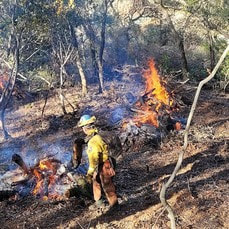 Vegetation Management Activities DWR and CAL FIRE have resumed vegetation management activities in the Loafer Creek Recreation Area. CAL FIRE hand crews and heavy equipment operators will be working throughout Loafer Creek and along HWY 162 (Oro Quincy Highway) for the next several months. Starting the week of Oct. 16, CAL FIRE will be performing prescribed burns at Loafer Creek. Work is weather dependent and may require nearby temporary trail closures. Smoke from pile burning activities will be visible in the Oroville area. These activities are removing overgrown ladder fuels, dead and dying vegetation, and minimizing ground fuels to create a more wildfire-resilient landscape. DWR’s Fuel Load Management Plan works to reduce wildfire risk, increase public safety, and enhance forest health around the Lake Oroville area. Ongoing vegetation management of this critical area remains a high priority for DWR and its partners at CAL FIRE, Butte County Fire Department, Butte County Sheriff’s Office, California Conservation Corps (CCC), California Department of Parks and Recreation (State Parks), and the Butte County Fire Safe Council. Vegetation management activities are ramping up for the season and will continue through Spring 2024 as weather conditions permit and crews are available. 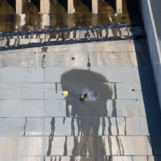 MAINTENANCE WORK ON MAIN SPILLWAY UNDERWAY Routine concrete and sealant repair work on localized areas of Oroville Dam’s main spillway continues this month. While the main spillway continues to perform well and operate as designed, periodic concrete and sealant repairs of the spillway are expected due to seasonal temperature variations, spillway releases, and sun exposure. In 2023, Oroville Dam’s main spillway passed over 2,370,000 acre-feet of water – approximately 67 percent of the capacity of Lake Oroville. Construction work is expected to continue through Nov. 15 but is dependent on weather and Oroville Dam operations. DWR will monitor reservoir levels and weather forecasts closely and will complete repair work early if spillway releases are required for flood control. Approximately 500 square-feet of total concrete repairs are anticipated, representing less than 0.1 percent of the spillway’s surface. Work so far has included inspection of approximately 40 percent of the 51,000 feet of piping that supports the spillway’s improved drainage system. The contractor also began concrete maintenance and joint sealant work on select chute slab and wall joints this week. The spillway was rebuilt to the highest engineering and safety standards with oversight and guidance by the Federal Energy Regulatory Commission (FERC), Division of Safety of Dams (DSOD), and an independent board of consultants. DWR performed a significant amount of inspection and testing throughout construction to verify compliance with project specifications. DWR also provides regular updates to the Oroville Dam Citizens Advisory Commission, a public forum for discussing operations, maintenance, and public safety activities at Oroville Dam and its facilities.  OROVILLE RECREATION
DWR biologists are using the Feather River Fish Monitoring Station to determine abundance, run timing, and origin (hatchery or natural) of steelhead and Chinook salmon populations. This information will improve the management of these important fish populations. Upstream migrating fish totals between Sept. 11 and Oct. 2 are:
The Lake Oroville Visitor Center is open seven days a week from 9 a.m. to 5 p.m. Staffed by knowledgeable guides, the Visitor Center features interpretive displays on Oroville Dam, area geology, wildlife and habitat, hydroelectric power, and cultural and historical artifacts. View videos in the theater about the construction of Oroville Dam, walk or hike along nearby trails, and visit the 47-foot-tall observation tower that provides unsurpassed panoramic views of surrounding areas. Free guided tours for school and community groups are available by reservation. Parking and admission to the Visitor Center are free. CURRENT LAKE OPERATIONS Lake Oroville is at 827 feet elevation and storage is approximately 2.52 million acre-feet (MAF), which is 71 percent of its total capacity and 135 percent of the historical average. Feather River releases are at 4,000 cubic feet per second (cfs) and will be reduced to 2,450 cfs by Sunday, Oct. 15. Flows through the City of Oroville remain at 650 cfs with releases from the Thermalito Afterbay Outlet (Outlet) being reduced to 1,800 cfs by Sunday for a total of 2,450 cfs downstream of the Outlet. DWR continues to assess releases to the Feather River daily. DWR’s Water Operations division has begun adjusting reservoir levels in accordance with the U.S. Army Corps of Engineers Water Control Manual. This is done each year in preparation for the winter season to provide flood control protection to downstream communities and obtain additional space in the lake for increased storm runoff. Additionally, DWR’s Water Operations division monitors forecasts closely to predict incoming storm impacts and determine whether to release additional water to account for higher estimated inflows. Visitors to Oroville Dam may also notice minor amounts of water flowing from drains built into the emergency spillway, which is normal and expected with the emergency spillway design. The dam and emergency spillway continue to operate as intended. The public can track precipitation, snow, reservoir levels, and more at the California Data Exchange Center. The Lake Oroville gage station is identified as “ORO.” All data as of midnight 10/12/2023. Comments are closed.
|
Archives
May 2024
Categories
All
|
 RSS Feed