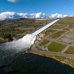
 Lake Oroville Water Releases Continue The Department of Water Resources (DWR) continues to make releases from Lake Oroville using the main spillway at Oroville Dam. Ongoing releases ensure continued storage space in Lake Oroville for spring runoff from snowmelt and are closely coordinated with the U.S. Army Corps of Engineers and downstream water operators. Total releases to the Feather River amount to 10,000 cubic feet per second (cfs) with 2,200 cfs being routed down the low-flow channel which flows through the City of Oroville. An additional 7,800 cfs is being released from the Thermalito Afterbay River Outlet, located 5 miles downstream from Oroville. Water releases from Lake Oroville are schedule to be further reduced to 7,000 cfs on Friday, May 5. DWR continues to closely monitor lake levels and will adjust releases accordingly to optimize operations for water storage and environmental protection while allowing for carryover storage into next year. Since Dec. 1, Lake Oroville’s storage has increased more than 220 feet and gained over 2.2 million acre-feet of water. Lake Oroville is currently at 92 percent capacity and is expected to reach full capacity this spring. The Lake Oroville reservoir is the largest storage facility in the State Water Project (SWP) and supports environmental and water delivery needs to 27 million Californians and reduces flood risks to downstream communities. 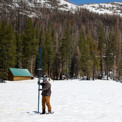 FINAL SNOW SURVEY CONDUCTED DWR conducted the fifth snow survey of the season at Phillips Station this week. The manual survey recorded 59 inches of snow depth and a snow water equivalent of 30 inches, which is 241 percent of average for this location on May 1. The snow water equivalent measures the amount of water still contained in the snowpack and is a key component of DWR’s water supply run-off forecast. DWR’s electronic readings from 130 snow sensors placed throughout the state indicate the statewide snowpack’s snow water equivalent is 49.2 inches, or 254 percent of average for this date. Snow surveys like the one at Phillips Station are critical to planning for impacts of the coming snowmelt runoff on communities. DWR uses the most updated technology to gather data from snow surveys, a network of 130 remote snow sensors, and airborne snow observatory data to gather information on current real-world conditions to create the most accurate snowmelt runoff forecasts possible. These runoff forecasts allow reservoir operators to plan for anticipated inflows and water managers downstream of reservoirs to plan and prepare for flood risks. Read more about the latest snow survey in DWR’s press release. 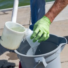 BLUE GREEN ALGAE MONITORING DWR’s environmental scientists began monitoring for blue-green algae and their toxins last week within the Oroville-Thermalito Complex and the upper Feather River lakes. Monitoring occurs during the summer months with water samples taken at various locations regularly, which are sent to a lab for toxin analysis. There are currently no harmful algal bloom (HAB) advisories for Lake Oroville, Upper Feather River lakes, the Thermalito Forebay, or the Thermalito Afterbay. Blue-green algae (cyanobacteria) is a natural component of ecosystems. Under certain conditions, including warmer temperatures and increased nutrient loads, algae can grow rapidly causing “blooms.” Algal blooms sometimes produce toxins that can be harmful to people and animals. Algal blooms can make the water appear green, blue, or brown in color. Seeing colors, mats, foam, scum, or paint-like streaks in the water may indicate a bloom is present. Keep animals and children away from the water when a suspected bloom is present and report blooms immediately to the California Regional Water Quality Control Board. If elevated levels of cyanobacteria toxins are found while testing, DWR staff will work with California’s Regional Water Quality Control Board and recreation area managers to notify the public and post advisory signs at affected waterbodies. To learn more about HABs, or to report a HAB visit the Water Board’s website.  OROVILLE RECREATION ADVISORY COMMITTEE The Oroville Recreation Advisory Committee (ORAC) will hold a public meeting on Friday, May 5 starting at 10 a.m. at the Southside Oroville Community Center located at 2959 Lower Wyandotte Road, Oroville, CA, 95966. ORAC was established by the Federal Energy Regulatory Commission (FERC) to review and provide recommendations regarding the Department of Water Resources (DWR) recreation plan for the Oroville Facilities. The 13-member committee is made up of representatives from state and local government, recreation groups, and business and community organizations. To obtain a summary of the meeting, send a request to [email protected]. FEATHER FIESTA DAYS For more than 70 years, Feather Fiesta Days has been Oroville’s premier hometown celebration with two weekends filled with activities. Festivities began last weekend with the main activities, including a parade and Gold Rush car show, scheduled for this Saturday, May 6. Stop by DWR’s booth in downtown Oroville on May 6 from 10 a.m. to 4 p.m. to learn about recreation opportunities around Lake Oroville. Activities for kids include making a sailboat and water safety handouts. Learn more about Feather Fiesta Days activities on the Oroville Chamber of Commerce website. 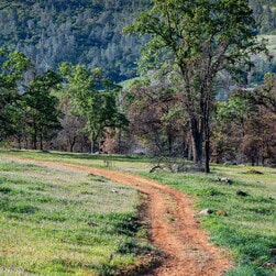 OROVILLE RECREATION
The Lake Oroville Visitor Center is open Monday through Friday between 9 a.m. and 5 p.m. The Visitor Center offers numerous educational exhibits, a theater featuring videos about the building of Oroville Dam, and a 47-foot-tall observation tower providing unsurpassed panoramic views. DWR, State Parks, and CDFW maintain over 92 miles of trails in the Oroville area. An interactive map of recreation facilities, including open boat ramps, and their permitted uses is available on DWR’s Lake Oroville Recreation webpage. A paper trail map is available at various locations, including most entrance kiosks and the Visitor Center. The marinas at Bidwell Canyon and Lime Saddle are open daily and provide a variety of services such as a shuttle and boat rentals. CURRENT LAKE OPERATIONS Lake Oroville is at 882 feet elevation and storage is approximately 3.26 million acre-feet (MAF), which is 92 percent of its total capacity and 119 percent of the historical average. The Feather River releases are at 10,000 cubic feet per second (cfs). Flows through the City of Oroville are 2,200 cfs with 7,800 cfs released from the Thermalito Afterbay Outlet (Outlet) for a total of 10,000 cfs downstream of the Outlet. Water releases from Lake Oroville are schedule to be further reduced to 7,000 cfs on Friday, May 5. DWR continues to assess releases to the Feather River daily. The public can track precipitation, snow, reservoir levels, and more at the California Data Exchange Center. The Lake Oroville gage station is identified as “ORO”. All data as of midnight 5/3/2023. Comments are closed.
|
Archives
May 2024
Categories
All
|
 RSS Feed