 June 25, 2021 Oroville Wildlife Area Habitat Project The sunflowers and safflowers planted this spring on 60 acres of the Oroville Wildlife Area (OWA) are growing taller. The nearly 12,000-acre OWA in Butte County is a popular stopping place on the Pacific Flyway for migrating and native birds. Managed by the California Department of Fish and Wildlife (CDFW) for the Department of Water Resources (DWR), the OWA also includes DWR’s Thermalito Afterbay reservoir, a prime habitat for migrating waterfowl and several endangered species. CDFW farms more than 300 acres of grains, grasses, and flowering plants in the OWA to provide food (forage), shelter, and nesting cover for migratory and native birds. Recently, 60 acres in various locations around the Thermalito Afterbay were planted with sunflowers and safflowers. Read more about CDFW’s 50 years of using dry-land farming techniques to add diversity to the area’s wildlife habitat on the DWR Updates webpage. DWR will be tracking the success of these 60 acres over the summer and photos can be found on DWR’s public photo sharing site by using the search term “Oroville Wildlife Area Planting”. Photo: Sunflowers grow in the Oroville Wildlife Area to provide forage and habitat for wildlife and birds. Drought Information California is no stranger to drought; it is a recurring feature of our climate. Lake Oroville’s low lake levels are a reminder of this cycle of dry and wet years. This year’s drought conditions are being felt across the western United States, with many areas, including California’s Central Valley, identified as being in “extreme drought” - the highest category of drought conditions. DWR has created a “Drought” webpage where definitions, historical trends, current information, and maps of California’s water systems can be found. Links to resources, DWR activities, research, and data are available. Read about how heatwaves are impacting drought conditions on the DWR Updates webpage. DWR is encouraging water conservation efforts by all Californians. Find out ways you can help by visiting the “Save Our Water” website.  Oroville Recreation Bidwell Canyon Boat Ramp is currently open with future status dependent on lake levels. Boat ramp information can be obtained by calling the California Department of Parks and Recreation (CA Parks) at (530) 538-2200 or visiting the Lake Oroville State Recreation Area (LOSRA) website at www.parks.ca.gov/LakeOroville. Both the Lime Saddle and Bidwell Canyon marinas will remain open 8 a.m. until sundown. Visitors to the Thermalito North Forebay will find a full CA Parks facility with restrooms, picnic areas, a swim beach, and the Forebay Aquatic Center with kayaks, paddle boards, and other watercraft available for rent. The Monument Hill facility at the Thermalito Afterbay also provides boat ramp access, restrooms, a picnic area, and a swim beach. More than 97 miles of trails and numerous Day Use Area (DUA) facilities with picnic tables and restrooms at Lake Oroville State Recreation Area (LOSRA) are open 8 a.m. to sunset. Bidwell, Lime Saddle, and Loafer Creek Recreation Areas are open 24 hours. Summer access hours of 5 a.m. to 11 p.m. daily is now in effect for the Spillway Boat Ramp Area - gates close at 11 p.m. Vehicle access to Oroville Dam Crest Road across Oroville Dam is available 5 a.m. to 11 p.m. daily and open to pedestrians and bicyclists 24-hours a day. The Lake Oroville Visitor Center remains closed due to COVID-19 restrictions. Visit the California Parks LOSRA webpage for current information on facility status, campground reservations, and to find current requirements to protect public health during the COVID-19 pandemic. An interactive map of recreation facilities in DWR’s Oroville-Thermalito Complex is available on DWR’s Lake Oroville Recreation webpage. Information about the 11,000-acre Oroville Wildlife Area is available on the California Department of Fish and Wildlife webpage. Photo: Swim beach at North Forebay Recreation Area 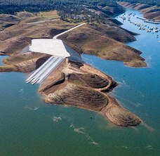 Grazing Goats Reduce Fire Risk
Hillsides along the Dan Beebe and Bidwell Canyon trails near Kelly Ridge look quite different after 1,600 goats and sheep from the Hanski Family Farms visited the area. The goat grazing project is part of DWR’s Fuel Load Management Plan, which helps reduce wildfire risk, increase public safety, and enhance forest health in areas around Lake Oroville within the Federal Energy Regulatory Commission (FERC) project boundary. In partnership with Butte County Fire Safe Council, DWR utilized grazing as a sustainable method of fuel reduction on about 35 acres to help minimize the risk or lessen the spread of a wildfire. To learn more and see goat grazing in action, visit DWR’s YouTube channel for a video of the March 2021 Lakeland Blvd. goat grazing project. Photo: Grazed and un-grazed hillsides near Kelly Ridge Current Lake Operations The elevation of Oroville’s reservoir is about 690 feet elevation and storage is about 1.18 million acre-feet -- 34 percent full and 41 percent of historical average. Currently, in the Northern Sierra Basin, snowpack is also below average at five percent of normal. An Excessive Heat Watch is in effect beginning this weekend (Saturday) through Wednesday in the Northern and Central Sacramento Valley. Temperatures are forecast to be over 100 degrees throughout the weekend and next week. Total flow to the Feather River is currently at 2,750 cubic feet per second (cfs) for meeting downstream water quality and flow requirements. Flow down the low flow channel, through the City of Oroville, is 2,150 cfs and flow through the Thermalito Afterbay Outlet is 600 cfs. Currently, these flow patterns will hold through the weekend. Plans to reduce flows in the low flow channel at a rate of 300 cfs per day to the Thermalito Afterbay Outlet will be scheduled until its desired level is reached. Current releases are re-assessed on a daily basis. The public can track precipitation, snow, reservoir levels, and more at the California Data Exchange Center at www.cdec.water.ca.gov. Lake Oroville is identified as “ORO”. All data as of midnight - 6/24/2021 ### Know someone who would like to receive Community Updates? They can email their request to [email protected]. Comments are closed.
|
Archives
May 2024
Categories
All
|
 RSS Feed