 June 11, 2021 Thermalito Afterbay Outlet Work A project to increase the operational reliability of the Thermalito Afterbay Outlet radial gates will require closure of the gates to allow divers to perform underwater work. Required flows to the Feather River will be routed to the river’s Low Flow Channel that runs from the Thermalito Diversion Dam through Oroville beginning on June 11. Flows will gradually increase from 950 cubic feet per second (cfs) to 2,550 cfs by June 15 resulting in swift water and an increase in river height of about one foot from the Thermalito Diversion Dam down to the Thermalito Afterbay River Outlet. The gates will be closed until June 21 with river flows through the Low Flow Channel gradually decreasing the rest of that week as flows from the Thermalito Afterbay Outlet are restored. River users are always advised to be aware of currents and colder water temperatures. Lake Oroville Boat Ramp Status The Lime Saddle and Loafer Point boat ramps closed June 3. Although water may still cover the bottom of a boat ramp, there is not enough depth over the paved ramp to safely launch and trailer boats. Both the Lime Saddle and Bidwell Canyon marinas will remain open from 8 a.m. until sundown. The Spillway boat ramp will remain open for the weekend of June 12 to June 13 and is anticipated to close early next week. Bidwell Canyon is currently open with future status dependent on lake levels. Boat ramp information can be obtained by calling the CA Department of Parks and Recreation (CA Parks) at 530-538-2200 or visiting the Lake Oroville State Recreation Area (LOSRA) website at www.parks.ca.gov/LakeOroville. Grazing Goats Reduce Fire Risk Over 1,500 bleating goats mixed with sheep may be heard by trail users and Kelly Ridge residents beginning Sunday, June 13 in the Kelly Ridge area. Grazing efforts will start at the Saddle Dam Recreation Area, move north along the Dan Beebe and Bidwell Canyon trails, and will finish near the Bidwell Canyon recreation area at Arroyo Drive. DWR in partnership with Butte County Fire Safe Council, has contracted with Hanski Family Farms in Paradise to utilize grazing as a sustainable method of fuel reduction to help minimize the risk or lessen the spread of a wildfire. The goats and sheep will graze on dried grasses, leaves, invasive and non-invasive plants including poison oak and star thistle, and a variety of shrubs and trees. By standing on their hind legs, goats can reduce ladder fuels (overgrown vegetation that allows fire to climb from the forest floor into the taller shrubs and into the tree canopy) up to four feet high. The grazing area will be cordoned off with an electric fence and monitored by herdsmen and livestock guardian dogs to protect the animals. The public is urged to stay clear of the electric fence and keep pets away, so the goats are not disturbed. This work is part of DWR’s Fuel Load Management Plan which helps reduce wildfire risk, increase public safety, and enhance forest health in areas around Lake Oroville within the Federal Energy Regulatory Commission (FERC) project boundary. Approximately 34 acres will be grazed over the next couple weeks. To learn more and see goat grazing in action, visit DWR’s YouTube channel for a video of the March 2021 Lakeland Blvd. goat grazing project. Photo: Grazing goats feast on shrubs and trees at Lakeland Blvd. in April  Oroville Recreation More than 97 miles of trails and numerous Day Use Area (DUA) facilities with picnic tables and restrooms at Lake Oroville State Recreation Area (LOSRA) are open 8 a.m. to sunset. Bidwell, Lime Saddle, and Loafer Creek recreation areas are open 24 hours. Summer access hours of 5 a.m. to 11 p.m. daily is now in effect for the Spillway Boat Ramp Area - gates close at 11 p.m. Vehicle access to Oroville Dam Crest Road across Oroville Dam is available 5 a.m. to 11 p.m. daily. Exercise enthusiasts can log a round-trip of just over two miles while they enjoy the spectacular views from Oroville Dam Crest Road across the top of the dam, which is open to walkers, joggers, and bicyclists 24-hours a day. Surrounded by trails, the Thermalito Diversion Pool is open for kayaking and other non-motorized boating. Visitors to the Thermalito North Forebay will find a full CA Parks facility with restrooms, picnic areas, a swim beach, and the Forebay Aquatic Center with kayaks, paddle boards, and other watercraft available for rent. The Monument Hill facility at the Thermalito Afterbay also provides boat ramp access, restrooms, picnic area, and a swim beach. The Feather River Fish Hatchery’s viewing area and fish ladder are open to the public. The Lake Oroville Visitor Center remains closed due to COVID-19 restrictions. Visit the California Parks LOSRA webpage for current information on facility status, campground reservations, and to find current requirements to protect public health during the COVID-19 pandemic. An interactive map of recreation facilities in DWR’s Oroville-Thermalito Complex is available on DWR’s Lake Oroville Recreation webpage. Information about the 11,000-acre Oroville Wildlife Area is available on the California Department of Fish and Wildlife webpage. Photo: Hiking on trails near Thermalito Forebay 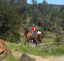 Thermalito Forebay Control Burn Successful A series of vegetation management control burns around the Thermalito Forebay was conducted by CAL FIRE/Butte County Fire Department on June 3 in cooperation with the Department of Water Resources (DWR) and CA Parks. A total of about 245 acres was successfully treated. The vegetation management control burns have multiple beneficial impacts grasslands around the Thermalito Forebay, including seasonal wetlands called vernal pools. Although vernal pools are only a small component of these grasslands, they support a high diversity of California native plants and animals, including rare and endangered species and species endemic to California (i.e., found nowhere else in the world). Fire from carefully controlled burns is the most powerful tool to combat invasive plants and dry invasive grass buildup called ‘thatch’ within these grasslands and vernal pools. The burns will also remove dangerous fire fuels from grassland adjacent to private property and near high-use areas. Photo: Control burn removes invasive plants and grasses near vernal pool area. 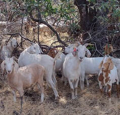 Blue Green Algae Monitoring
DWR environmental scientists regularly monitor for blue-green algae and their toxins during the summer months. There are currently no harmful algal blooms (HAB) advisories for Lake Oroville, the Thermalito Forebay, or the Thermalito Afterbay. Water samples are taken at various locations regularly from Memorial Day through Labor Day and sent to a lab for toxin analysis. Blue-green algae (cyanobacteria) is a natural component of ecosystems. Under certain conditions, including warmer temperatures and increased nutrient loads, algae can grow rapidly causing “blooms.” Algal blooms sometimes produce toxins that can be harmful to people and animals. Keep animals and children away from the water when a suspected harmful algal bloom (HAB) is present and report the possible HAB immediately. If elevated levels of cyanobacteria toxins are found, DWR staff will work with California’s Regional Water Quality Control Board and recreation area managers to notify the public and post advisory signs at affected waterbodies. To learn more about HABs or to report a HAB visit the Water Board’s website. Photo: Algal bloom on Lake Oroville's West Branch in August 2020 Current Lake Operations The elevation of Oroville’s reservoir is about 703 feet elevation and storage is about 1.28 million acre-feet -- 36 percent full and 43 percent of historical average. Currently, in the Northern Sierra Basin, snowpack is also below average at five percent of normal. Temperatures are forecast to be in the mid- to high-90s over the weekend increasing to near or above 100 towards the end of the week. On Monday, June 7, 2021, total flows to the Feather River were increased from 2,050 cfs to 2,550 cfs for downstream water quality and flow requirements. At this rate, flows down the low flow channel, through the City of Oroville are at 950 cfs and 1,600 cfs is being released from the Thermalito Afterbay Outlet (Outlet). Due to work at the Outlet, flows down the low flow channel will gradually increase to 2,550 beginning on June 11, reach 2,550 on June 15, and continue through June 21. Current releases are for meeting downstream water quality and flow requirements and are re-assessed on a daily basis. The public can track precipitation, snow, reservoir levels, and more at the California Data Exchange Center at www.cdec.water.ca.gov. Lake Oroville is identified as “ORO”. All data as of midnight 6/10/2021 ### Know someone who would like to receive Community Updates? They can email their request to [email protected]. Comments are closed.
|
Archives
May 2024
Categories
All
|
 RSS Feed