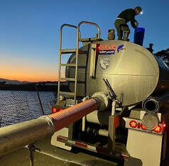
 July 2, 2021 Fourth of July Fireworks at Oroville The Oroville Rotary Club will be holding a Fourth of July celebration at the Oroville Municipal Airport on Independence Day. While there will not be public access to the airport facility for the fireworks show, public areas around the airport will be accessible by personal vehicle to tailgate during the event. The nearby Clay Pit State Vehicle Recreation Area will be closed for safety reasons. A fly-in event in the morning at the airport will also take place. The fireworks show will begin 30 minutes after sunset. Information on suggested viewing locations and other event information is available on the Oroville Area Chamber of Commerce website at: https://www.visitoroville.com/oroville-fireworks.html. Photo: On the North Forebay in Oroville waiting for fireworks to start. Oroville Recreation The Bidwell Canyon Boat Ramp will be open over the Fourth of July holiday weekend with future status dependent on lake levels. The gravel, single-lane, 4-wheel drive only, boat ramp at the Spillway opens this afternoon, July 2. Boat ramp information can be obtained by calling the California Department of Parks and Recreation (CA Parks) at (530) 538-2200 or visiting the Lake Oroville State Recreation Area (LOSRA) website at www.parks.ca.gov/LakeOroville. Both the Lime Saddle and Bidwell Canyon marinas will remain open 8 a.m. until sundown. Summer access hours of 5 a.m. to 11 p.m. daily is now in effect for the Spillway Boat Ramp Area - gates close at 11 p.m. The Oroville Dam Crest Road across Oroville Dam is available 5 a.m. to 11 p.m. daily and open to pedestrians and bicyclists 24-hours a day. The Lake Oroville Visitor Center anticipates re-opening later this summer. Visitors to the Thermalito North Forebay will find a full CA Parks facility with restrooms, picnic areas, a swim beach, and the Forebay Aquatic Center with kayaks, paddle boards, and other watercraft available for rent. The Monument Hill facility at the Thermalito Afterbay also provides boat ramp access, restrooms, a picnic area, and a swim beach. Visit the California Parks LOSRA webpage for current information on facility status and campground reservations. An interactive map of recreation facilities in DWR’s Oroville-Thermalito Complex is available on DWR’s Lake Oroville Recreation webpage at https://water.ca.gov/What-We-Do/Recreation/Lake-Oroville-Recreation. Information about the 11,000-acre Oroville Wildlife Area is available on the California Department of Fish and Wildlife webpage at https://wildlife.ca.gov/Lands/Places-to-Visit/Oroville-WA. Photo: Camping at the Lake Oroville State Recreation Area Lake Oroville Visitor Center CA Parks and DWR have issued a news release announcing both will be offering expanded educational opportunities at the Lake Oroville Visitor Center and State Recreation Area in the coming months. DWR is exclusively managing the Visitor Center as CA Parks transitions its educational programming away from the Visitor Center to various LOSRA locations as it further expands outdoor educational programs to educate visitors and provide high-quality outdoor recreation opportunities. DWR is recruiting additional staff to support operations and to assist with enhanced educational opportunities and informational displays at the Visitor Center that highlight California’s water delivery system and the importance of water in our lives. The Visitor Center will reopen later this year. 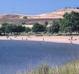 Oroville Wildlife Area Habitat Project The sunflowers and safflowers planted this spring on 60 acres of the Oroville Wildlife Area (OWA) are growing taller. The nearly 12,000-acre OWA in Butte County is a popular stopping place on the Pacific Flyway for migrating and native birds. Managed by the California Department of Fish and Wildlife (CDFW) for the Department of Water Resources (DWR), the OWA also includes DWR’s Thermalito Afterbay reservoir, a prime habitat for migrating waterfowl and several endangered species. CDFW farms more than 300 acres of grains, grasses, and flowering plants in the OWA to provide food (forage), shelter, and nesting cover for migratory and native birds. Recently, 60 acres in various locations around the Thermalito Afterbay were planted with sunflowers and safflowers. Read more about CDFW’s 50 years of using dry-land farming techniques to add diversity to the area’s wildlife habitat on the DWR Updates webpage. DWR will be tracking the success of these 60 acres over the summer and photos can be found on DWR’s public photo sharing site by using the search term “Oroville Wildlife Area Planting”. Photo: Sunflowers grow in the Oroville Wildlife Area to provide forage and habitat for wildlife and birds. Drought Information California is no stranger to drought; it is a recurring feature of our climate. Lake Oroville’s low lake levels are a reminder of this cycle of dry and wet years. This year’s drought conditions are being felt across the western United States, with many areas, including California’s Central Valley, identified as being in “extreme drought” - the highest category of drought conditions. DWR has created a “Drought” webpage where definitions, historical trends, current information, and maps of California’s water systems can be found. Links to resources, DWR activities, research, and data are available. Read about how heatwaves are impacting drought conditions on the DWR Updates webpage. DWR is encouraging water conservation efforts by all Californians. Find out ways you can help by visiting the “Save Our Water” website. 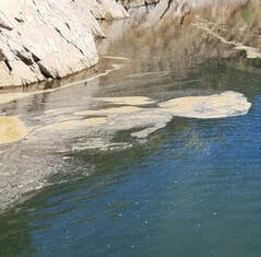 Blue Green Algae Monitoring
DWR environmental scientists regularly monitor for blue-green algae and their toxins during the summer months. There are currently no harmful algal bloom (HAB) advisories for Lake Oroville, the Thermalito Forebay, or the Thermalito Afterbay. Water samples are taken at various locations regularly from Memorial Day through Labor Day and sent to a lab for toxin analysis. If elevated levels of cyanobacteria toxins are found while testing, DWR staff will work with California’s Regional Water Quality Control Board and recreation area managers to notify the public and post advisory signs at affected waterbodies. To learn more about HABs, or to report a HAB visit the Water Board’s website. Photo: Algal bloom on Lake Oroville's West Branch Current Lake Operations The elevation of Oroville’s reservoir is about 681 feet elevation and storage is about 1.12 million acre-feet -- 32 percent full and 39 percent of historical average. Currently, in the Northern Sierra Basin, snowpack is also below average at five percent of normal. Warm temperatures in the ranging in the high 90s and low 100s continue this weekend through next week. Total flow to the Feather River is currently at 3,000 cubic feet per second (cfs) for meeting downstream water quality and flow requirements. Flow down the low flow channel, through the City of Oroville, is 1,550 cfs and flow through the Thermalito Afterbay Outlet is 1,450 cfs. Currently, these flow patterns will hold through the weekend. Current releases are re-assessed on a daily basis. The public can track precipitation, snow, reservoir levels, and more at the California Data Exchange Center at www.cdec.water.ca.gov. Lake Oroville is identified as “ORO”. All data as of midnight 7/1/2021 ### Know someone who would like to receive Community Updates? They can email their request to [email protected]. Comments are closed.
|
Archives
May 2024
Categories
All
|
 RSS Feed