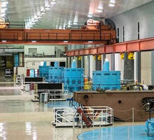
 January 7, 2022 Hyatt Powerplant Returns to Service Oroville Dam’s Hyatt Powerplant returned to service on Jan. 1, 2022 after going offline on Aug. 5, 2021 due to historic low lake levels driven by the state’s ongoing severe drought conditions. An unexpectedly strong atmospheric river storm in late October, followed by a series of powerful December storms, has increased reservoir elevation levels from 630 feet on Oct. 21 to 724 on Jan. 7 – a gain of over 90 feet. Water levels are now well above the powerplant’s intakes, providing the necessary water pressure for efficient operation of the plant. Currently, Hyatt powerplant is utilizing one generating unit to produce electricity and supply it to the state’s electrical grid managed by the California Independent System Operator. Hyatt generation will initially remain low due to low agricultural demands and improved delta salinity conditions. DWR anticipates an average outflow of about 900 cubic feet per second, which will generate approximately 30 megawatts of power. As lake levels rise and demands increase, additional units will be brought back online. The opportunity to perform maintenance on the powerplant’s infrastructure while the plant was offline allowed staff to enter equipment across the plant to perform inspections and replace protective equipment to ensure the plant maintains its reliability and is available for water deliveries and provision of clean hydropower to help meet the state’s clean energy goals in the upcoming water year. Read the news release at DWR News Releases. Photo: Hyatt Powerplant at Oroville Dam (showing four of the six generating units)  25th Anniversary of 1997 Floods At the start of the new year in 1997, an atmospheric river from the warm waters near Hawaii, what used to be called a “pineapple express”, drenched the Sierra foothills – up to 40 inches of precipitation over the course of the storm in some locations. Multiple rivers and flood channels overflowed, and areas up and down California’s Central Valley experienced breached levees, flooded farmland, and inundated towns and highways. The result was over $2 billion in damage and three lives lost. In the years since, the Department of Water Resources (DWR), through key improvements in forecasting, resources, levee infrastructure, and reconnected floodplain, has worked tirelessly with multiple partners to improve California’s ability to predict, prepare for, and respond to atmospheric river storms that often cause such damaging flood events. Read more about these efforts and find links to this year’s coverage of the anniversary on the DWR Updates webpage. Photo: Flooded trailer park near the San Joaquin River during 1997 New Year's Floods Drought Update California continues to benefit from winter storms, bringing much needed rain and snow to the state. On average, California receives 75 percent of its precipitation from November through March, half of which is typically received between December through February. The record-setting late October atmospheric river storm and the series of strong storms in December are providing a good start to the Sierra snowpack currently at around 57 percent of seasonal average and about 144 percent of average for this date. California needs above average precipitation throughout the winter to offset the record-setting drought conditions. Currently, Lake Oroville is only filled to 40 percent of its capacity and major reservoirs across the state are at an average of 37 percent capacity. The outlook for the rest of the winter is for the weather to turn drier in the new year. While there may be more dry days than wet, large atmospheric rivers can still occur, depositing substantial precipitation in a short period as we saw in October. This raises the risk of flood events, especially in burn scar areas. Loafer Creek Recreation Area The Loafer Creek Recreation Area at Lake Oroville continues to be temporarily closed due to damages and interruption of the park’s main water supply system. Hikers, bicyclists, and equestrians can still access area trails from the Saddle Dam trailhead facility off Kelly Ridge Road. Trail users are advised to be aware of California Department of Parks and Recreation (State Parks) work trucks and utility vehicles in the area.  Oroville Recreation
Bidwell Canyon’s Stage II concrete boat ramp and the Lime Saddle Boat Ramp are open. The Spillway boat ramp remains closed for repair and the Loafer Point boat ramp is inaccessible due to continued closure of the Loafer Creek Recreation Area. The Foreman Creek and Stringtown cartop boat ramps have also reopened. Information on current boat ramp status can be found on the State Park’s Lake Oroville State Recreation Area webpage. Scroll down to the link for “Current Boat Ramp Status”. The Lake Oroville Visitor Center is open to the public on Tuesdays, Wednesdays, and Thursdays from 9 a.m. to 5 p.m. Pick up the Lake Oroville Trails Map, which shows more than 97 miles of trails available to equestrians, bicyclists, and hikers, at Lake Oroville State Recreation Area (LOSRA) kiosks, the Oroville Area Chamber of Commerce, and Feather River Recreation and Parks District. Visit the California Parks LOSRA webpage for current information on facility status and campground reservations. An interactive map of recreation facilities in DWR’s Oroville-Thermalito Complex is available on DWR’s Lake Oroville Recreation webpage. Information about the 11,000-acre Oroville Wildlife Area is available on the California Department of Fish and Wildlife webpage. Photo: Walking Oroville Dam - nearly 2.3 miles across and back Current Lake Operations The elevation of Oroville’s reservoir is about 720 feet elevation and storage is about 1.41 million acre-feet, which is 40 percent of its total capacity and 75 percent of historical average. Dry and cool conditions are forecast over the weekend with a chance of rain next week. The average daily inflows from the storm activity the last week of December were in the range of 15,000 cfs to 17,000 cfs and are forecasted to taper to between 7,000 cfs to 9,000 cfs through the weekend. Inflows for the week of January 10 are projected in the range of 5,000 cfs to 6,000 cfs. Inflows are subject to change based upon on actual weather conditions and snow elevations. Total flows to the Feather River are at 950 cfs for meeting downstream water quality and flow requirements. Flow in the low-flow channel, through the City of Oroville, is 650 cfs and flow through the Thermalito Afterbay Outlet is 300 cfs. Releases are assessed daily. The public can track precipitation, snow, reservoir levels, and more at the California Data Exchange Center at www.cdec.water.ca.gov. The Lake Oroville gage station is identified as “ORO”. All data as of midnight 1/6/2022 ### Know someone who would like to receive Community Updates? They can email their request to [email protected]. Comments are closed.
|
Archives
May 2024
Categories
All
|
 RSS Feed