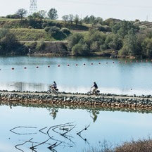
  Biking Around Lake Oroville While the spring and summer months may seem ideal for outdoor activities, winter remains a prime period for mountain biking throughout the Oroville area. Bikers not only enjoy cooler weather, but the dirt on recreation trails gets compacted by rainfall, offering increased traction following a few days of dry weather. With more than 70 miles of biking-designated trails throughout the Lake Oroville Recreation and Oroville Wildlife Areas, cyclists have a variety of trails and experiences to choose from. The Brad Freeman Trail loops throughout both recreation areas offering a 41-mile trek from the Oroville Dam Spillway area, past the Thermalito Diversion Pool, around the Thermalito Forebay and Afterbay, and through the remote Oroville Wildlife Area. Along the west side of Lake Oroville, the Potter’s Ravine system is a 15-mile trail with intermittent views of Lake Oroville. Cyclists can also bike another 8 miles from Potter’s Ravine along the North Fork Trail to the Bloomer Cove area showcasing the north fork arm of Lake Oroville. Those seeking a shorter trip may also bike from the Lake Oroville Visitor Center down to the Bidwell Canyon Saddle Dam, offering spectacular views of Lake Oroville during the ride. 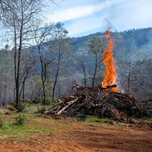 VEGETATION MANAGEMENT ACTIVITIES The Department of Water Resources (DWR) and CAL FIRE crews are resuming hand cutting, heavy equipment, and pile burning activities following the holiday season. Crews will be working in several areas throughout the Oroville Recreation Area – Loafer Creek along Highway 162 (Oro Quincy Highway) and around the Loafer Creek Campground, near Hyatt Powerplant along Oroville Dam Blvd. East, at the Lake Oroville Visitor Center, and throughout Bidwell Canyon. Work schedules are subject to change depending on weather, crew, and equipment availability. Work may cause intermittent trail closures within project areas. Recreational trail users should be cautious when entering work areas and obey all posted trail signage. Smoke from pile burning activities will be visible in the Oroville area. DWR’s Fuel Load Management Plan works to reduce wildfire risk, increase public safety, and enhance forest health around the Lake Oroville area. Ongoing vegetation management of this critical area remains a high priority for DWR and its partners at CAL FIRE, Butte County Fire Department, Butte County Sheriff’s Office, California Conservation Corps (CCC), California Department of Parks and Recreation (State Parks), and the Butte County Fire Safe Council. 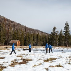 SNOW SURVEY DWR conducted the first snow survey of the season at Phillips Station on Jan. 2. The manual survey recorded 7.5 inches of snow depth and a snow water equivalent of 3 inches, which is 30 percent of average for this location. The snow water equivalent measures the amount of water contained in the snowpack and is a key component of DWR’s water supply forecast. Statewide the snowpack is 25 percent of average for this date. After one of the largest snowpacks on record last season, the start of this water year has been dry despite some recent storms in the last weeks of December that provided a small boost in the snowpack. While state reservoirs are still above average for this time of year and strong El Niño conditions are present in the Pacific Ocean, the outlook for the rest of the winter remains highly uncertain. More information about the first snow survey can be found in DWR’s press release. 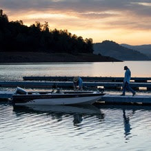 OROVILLE RECREATION
DWR, State Parks, and the California Department of Fish and Wildlife (CDFW) maintain over 92 miles of trails in the Oroville area. An interactive map of recreation facilities, including open trails and their permitted uses (hike, bike, horse, multi), is available on DWR’s Lake Oroville Recreation webpage. A paper trail map is available at various locations, including most entrance kiosks and the Lake Oroville Visitor Center. The marinas at Bidwell Canyon and Lime Saddle are open daily and provide a variety of services including a convenience store, gas, and boat rentals. The Lake Oroville Visitor Center is open daily from 9 a.m. to 5 p.m. Staffed by knowledgeable guides, the Visitor Center features interpretive displays on Oroville Dam, area geology, wildlife and habitat, hydroelectric power, and cultural and historical artifacts. View videos in the theater about the construction of Oroville Dam, walk or hike along nearby trails, and visit the 47-foot-tall observation tower that provides unsurpassed panoramic views of surrounding areas. Free guided tours for school and community groups are available by reservation. Parking and admission to the Visitor Center are free. Upstream migrating fish totals between Sept. 11 and Dec. 26 are:
CURRENT LAKE OPERATIONS Lake Oroville is at 820 feet elevation and storage is approximately 2.42 million acre-feet (MAF), which is 69 percent of its total capacity and 129 percent of the historical average. Feather River flows remain at 650 cubic feet per second (cfs) through the City of Oroville with 1,100 cfs being released from the Thermalito Afterbay River Outlet (Outlet) for a total Feather River release of 1,750 cfs downstream. DWR continues to assess releases to the Feather River daily. With rising water levels from recent storms, water may be seen on the main spillway outlet as the seals on the eight radial gates are not designed to be watertight. The gate seals do not play a role in the structural integrity of the gates, which continue to operate as intended. DWR periodically maintains and adjusts the seals during low-reservoir conditions to improve their sealing capability. Visitors to Oroville Dam may also notice minor amounts of water flowing from drains built into the emergency spillway, which is normal and expected with the emergency spillway design. The dam and emergency spillway continue to operate as intended. The public can track precipitation, snow, reservoir levels, and more at the California Data Exchange Center. The Lake Oroville gage station is identified as “ORO.” All data as of midnight 1/4/2024. Comments are closed.
|
Archives
May 2024
Categories
All
|
 RSS Feed