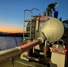
 January 22, 2021 Oroville Recreation The California Department of Parks and Recreation (CA Parks), in compliance with the modification for the Greater Sacramento Region’s COVID-19 public safety restrictions, has opened Lake Oroville State Recreation Area (LOSRA) campgrounds at Bidwell Canyon, Loafer Creek, including the Equestrian Campground, and the Lime Saddle Campground. Enroute camping at the North Forebay and Spillway facilities is also permitted. Group camping remains closed. Reservation capability does not open until April so camping sites are allocated on a ‘first come-first serve’ basis. The Potters Ravine and North Fork trails, damaged by the August 2020 Potters Fire, are also now open for use. CA Parks encourages users to remain on the trails and assessments by CA Parks staff of trail safety will continue through the winter. Additionally, day use facilities at Foreman Creek, Stringtown, and Enterprise, damaged by the September North Complex Fire, are now open to the public. The Lake Oroville Visitors Center remains closed. Visit the California Parks Lake Oroville State Recreation Area (LOSRA) webpage for current information on facility status as well as current requirements to protect public health during the COVID-19 pandemic. Information about recreation facilities can also be found in DWR’s interactive map on the Lake Oroville Recreation webpage. For information about the Oroville Wildlife Area, including the Thermalito Afterbay, visit the California Department of Fish and Wildlife webpage. Recreation Improvement Project Nearly Complete Construction is nearly complete at the Bidwell Canyon Stage II Boat Ramp Project. Visitors and users can enjoy full access to the expanded, paved parking area as well as the two additional boat ramp lanes which allow launching when the lake drops as low as 705 feet elevation. Currently, boaters are using the Stage III boat ramp at Bidwell Canyon which is open 24 hours per day and provides access to elevation 665 feet. The auxiliary gravel boat ramp at the Oroville Dam Spillway boat ramp area is now closed and users will be directed to the Bidwell Canyon boat ramps. The paved ramps at the Spillway (and other area boat launch facilities) will reopen again as lake levels rise from anticipated winter storms and place ramps back into the water. Photo: New Bidwell Canyon Boat Ramp access road and Stage II Project parking area with lower Stage III in background Flood After Fire Preparedness Risks for mud and debris flows to communities and homes downslope of areas burned by wildfire are increased when precipitation events occur. In normal conditions, trees, shrubs, grass, and other protective groundcover allow rainfall to infiltrate into the soil. In addition to removing vegetation, a wildfire’s extreme heat can bake the soil, further preventing water penetration. Due to these changes, even a small storm system in burn scar areas can cause flash flooding and lead to mud and debris flows. It is important to stay alert and be prepared before flooding occurs. Being ready also means knowing when to evacuate. Get the latest information from the National Weather Service at www.weather.gov – just enter your city or zip code. More information on flood after fire can be found in this short video as well as on the DWR website.  California Conservation Corps Constructs Fish Habitat from Recycled Christmas Trees The California Conservation Corps (CCC) has completed constructing fish habitat structures at Lake Oroville and the Thermalito Afterbay using the over 950 recycled Christmas trees. The trees were collected by Chico Boy Scout Troop 2 and the Biggs 4-H Club and delivered to DWR by Recology, a local waste management company. The habitat structures of stacked holiday trees were created by threading wire cable through CCC-drilled holes in the trunks and anchoring the cable to the lakebed in various locations. Anchoring the trees allows them to stay submerged as the lake’s water level rises from winter storm and snowmelt inflows. The structures provide juvenile fish safe refuge, improving fisheries and recreational fishing opportunities. For over 25 years, DWR has worked with local groups to construct fish habitat structures, which is one of the longest continuously running fish habitat improvement programs in the State of California. Photo: California Conservation Corps members anchor stacked Christmas trees to Lake Oroville's lakebed  Construction of Loafer Point Stage 2 Boat Ramps Constructing low water access boat ramp lanes in a reservoir presents unique challenges as contractors face rising water levels from winter precipitation and construction of the Loafer Point Stage 2 boat ramp project is no exception. Fortunately, the project to build six new boat launch lanes and 180 trailered parking spaces to allow boaters to enter the lake when lake elevations are below elevation 805 feet is making progress. This year’s low lake levels provided DWR the opportunity to build the ramp down to elevation 703 feet and the contractor has already placed over 115 feet of concrete. When the lake levels are lower due to dry years in the future, the ramp will be extended to lower lake elevations. The Loafer Point Stage 2 project will be adjacent to an existing Loafer Creek Recreation Day Use Area and Campground, rounding out a full-service recreation destination with nearby trails, campgrounds, boating, and marina. Additionally, immediate access to the wide-open waters of Lake Oroville will make Loafer Point a popular boat launching location. The recently completed Loafer Point Stage 1 boat launch added three new boat launch lanes from a full lake down to 799 feet, a new parking area, and new restroom facilities. Photo: Loafer Point Stage II Boat Ramp project - Bidwell Canyon Marina in background 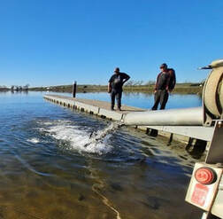 DWR Fuel Load Management Program
California Conservation Corps (CCC) members and crews supervised by the Butte County Sheriff’s Office are working in different locations at Loafer Creek Recreation Area to remove ladder fuels, dead and dying vegetation, and thin unhealthy overstocked trees and overgrown vegetation as part of the DWR Fuel Load Management Plan (FLMP). This ongoing DWR project reduces wildfire risk, increase public safety, and enhance forest and watershed health around Lake Oroville. With help from area partners, approximately 660 acres have been manually thinned, re-thinned, grazed, and/or treated with prescribed fire since November 2012. DWR’s goal is to treat an additional 1,000 acres over the next five years. Photo: Butte County Sheriff's Office Supervisor oversees a clearing and chipping operation Current Lake Operations The elevation of Oroville’s reservoir is about 695 feet and storage is about 1.21 million acre-feet. Currently, in the Northern Sierra Basin, rainfall is below average, at 37 percent of normal for this time of year and snowpack is also below average at 48 percent of normal. A series of storm systems are forecast starting as early as Friday, Jan. 22 and continuing through week of Jan. 25, with occasional dry periods. The total releases to the Feather River continues to be at 1,250 cfs to conserve storage in Lake Oroville. The Feather River flows consist of 800 cfs down the Low Flow Channel through the City of Oroville, and 450 cfs from the Thermalito Afterbay Outlet (Outlet) for a total of 1,250 cfs for the Feather River’s high flow channel downstream of the Outlet. All data as of midnight 1/21/2021 ### Know someone who would like to receive Community Updates? They can email their request to [email protected]. Comments are closed.
|
Archives
May 2024
Categories
All
|
 RSS Feed