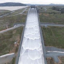
  Spillway Releases Begin at Oroville Dam The Department of Water Resources (DWR) began releasing water from Oroville Dam’s main spillway on Jan. 31. Ongoing releases to the Feather River ensure storage space remains in Lake Oroville for flood control protection to downstream communities. DWR coordinates releases closely with the U.S. Army Corps of Engineers and other water operators and adjusts releases as needed to account for continuing rain. The information below reflects current reservoir level estimates. Forecasts can change quickly and may affect the estimates provided.
Starting the week of Feb. 5, crews may also be seen working near the main spillway. Sections of the spillway’s underdrain system are being re-inspected to capture additional video footage. In addition, crews will be performing maintenance and repairs to the spillway’s lighting system. The Lake Oroville reservoir is the largest storage facility in the State Water Project, providing flood protection while supporting environmental and water delivery needs to 27 million Californians. In 2023, Oroville Dam’s main spillway passed over 2,370,000 acre-feet of water, 67 percent of Lake Oroville’s capacity, with flows as high as 36,000 cfs. The main spillway continues to perform well and operate as designed. DWR continues to monitor lake levels, weather forecasts, and mountain snow levels to optimize water storage while allowing for carryover storage into next year. Oroville Recreation Advisory Committee The Oroville Recreation Advisory Committee (ORAC) met Feb. 2 at the Southside Oroville Community Center. ORAC was established by the Federal Energy Regulatory Commission (FERC) to review and provide recreation plan recommendations for Oroville Facilities owned by DWR. The 13-member committee is made up of representatives from state and local government, recreation groups, and business and community organizations. To obtain a summary of the meeting, send a request to [email protected]. 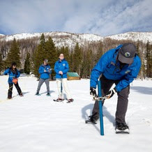 FEBRUARY SNOW SURVEY DWR conducted the second snow survey of the season at Phillips Station on Jan. 30. The manual survey recorded 29 inches of snow depth and a snow water equivalent of 10 inches, which is 58 percent of average for this location. The snow water equivalent measures the amount of water contained in the snowpack and is a key component of DWR’s water supply forecast. The results reflect a modest increase in the snowpack since Jan. 1, but overall conditions are still far below normal. DWR’s electronic readings from 130 stations placed throughout the state indicate that the statewide snowpack’s snow water equivalent is 8.4 inches, or 52 percent of average for this date, an improvement from just 28 percent of average on Jan. 1. One year ago, the snowpack statewide was 214 percent of average on Feb. 1. Despite additional precipitation in January, many storms so far this year have been warmer than average, producing rain rather than snow at higher elevations. Overall statewide precipitation is 82 percent of average for this date. Last year’s snowpack was aided by both above average precipitation and below average temperatures, which created a historic snowpack and improved reservoir storage statewide, which is still above average. Lake Oroville, the State Water Project’s largest reservoir, is currently 131 percent of average. More information about the recent snow survey can be found in DWR’s press release. 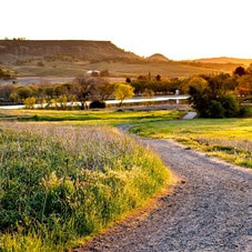 OROVILLE RECREATION
DWR, State Parks, and the California Department of Fish and Wildlife (CDFW) maintain over 92 miles of trails in the Oroville area. An interactive map of recreation facilities, including open trails and their permitted uses (hike, bike, horse, multi), is available on DWR’s Lake Oroville Recreation webpage. A paper trail map is available at various locations, including most entrance kiosks and the Lake Oroville Visitor Center. The Lake Oroville Visitor Center is open daily from 9 a.m. to 5 p.m. Staffed by knowledgeable guides, the Visitor Center features interpretive displays on Oroville Dam, area geology, wildlife and habitat, hydroelectric power, and cultural and historical artifacts. View videos in the theater about the construction of Oroville Dam, walk or hike along nearby trails, and visit the 47-foot-tall observation tower that provides unsurpassed panoramic views of surrounding areas. Free guided tours for school and community groups are available by reservation. Parking and admission to the Visitor Center are free. Lake Oroville is one of the State Water Project’s premier recreational destinations and one of California’s best fishing spots. The lake provides both warm-water and cold-water fisheries and is a popular destination for bass tournaments. Below the Oroville Dam, the Thermalito Afterbay and the Feather River offer additional excellent fishing opportunities. The marinas at Bidwell Canyon and Lime Saddle are open daily and provide a variety of services including a convenience store, gas, and boat rentals. Upstream migrating fish totals between Sept. 11, 2023 and Jan. 27, 2024 are:
CURRENT LAKE OPERATIONS Lake Oroville is at 842 feet elevation and storage is approximately 2.7 million acre-feet (MAF), which is 76 percent of its total capacity and 131 percent of the historical average. Feather River flows remain at 650 cfs through the City of Oroville with 9,350 cfs being released from the Thermalito Afterbay River Outlet (Outlet) for a total Feather River release of 10,000 cfs downstream. DWR continues to assess releases to the Feather River daily. Visitors to Oroville Dam may also notice minor amounts of water flowing from drains built into the emergency spillway, which is normal and expected with the emergency spillway design. The dam and emergency spillway continue to operate as intended. The public can track precipitation, snow, reservoir levels, and more at the California Data Exchange Center. The Lake Oroville gage station is identified as “ORO.” All data as of midnight 2/1/2024. Comments are closed.
|
Archives
May 2024
Categories
All
|
 RSS Feed