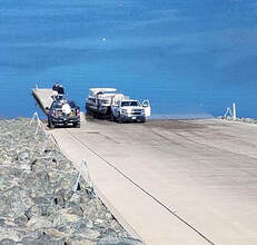
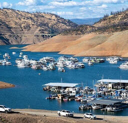
 April 16, 2021 Governor Visits Fuels Reduction Work Governor Gavin Newsom visited the Loafer Creek Recreation Area near Lake Oroville to sign a $536 million wildfire package on April 13. This money will go towards forest management projects and efforts to reduce wildfire risks around California, including projects in Butte County. Governor Newsom visited a work site where CAL FIRE, in partnership with Department of Water Resources (DWR), has crews actively working in the Loafer Creek Recreation Area within the North Complex wildfire burn scar. Crews are using heavy machinery and hand crews to cut, pile, and chip burnt vegetation and trees. The piles will be burned after rains begin later this fall. Operations are visible to motorists on Highway 162. This work is part of CAL FIRE’s Vegetation Management Program and DWR’s Fuel Load Management Plan (FLMP). Both plans aim to reduce wildfire risk, increase public safety, and enhance forest health in areas around Lake Oroville. Nearly 3,000 acres are targeted as part of DWR’s FLMP. To date, approximately 700 acres have been treated around the Lake Oroville area by DWR and its partners including CAL FIRE, the California Conservation Corps, Butte County Fire Safe Council (BCFSC), Butte County Sheriff’s Office, and California Department of Parks and Recreation (CA Parks). Previous FLMP work in the Loafer Creek area is credited for helping slow the North Complex wildfire, allowing firefighters time to establish the fire line that protected the communities of Kelly Ridge and Oroville. DWR, in partnership with BCFSC, will begin a vegetation management project along Highway 162 and Loafer Creek Road starting the week of April 19. This 13-acre project will take approximately one month to reduce overgrown vegetation and hazardous fuels. A one-lane road closure may be needed along the entrance to Loafer Creek Recreation Area. The public is advised to use caution around work activities and reduce speeds around crews and equipment. Photo: Reducing fire risk and burned trees at Loafer Creek Recreation Area  DWR Begins Monitoring Vernal Pools Some grasslands, including areas around Butte County, have an underlying impervious layer of rock or clay that causes rainwater to pond in the winter and spring, creating seasonal wetlands called vernal pools. Although vernal pools are only a small component of our local grasslands in terms of area, they support a remarkably high diversity of plants and animals, including rare and endangered species and species endemic to California (i.e., found nowhere else in the world). Vernal pool organisms and plants are highly specialized to their unique environment and to the Mediterranean-type climate found in California. They have adapted to living in pools that fill in the winter but are completely dry by the summer, as well as adapting to the sometimes-extreme variability in temperature and rainfall between years. Vernal pools are important targets for conservation because most vernal pools in California have been lost to development, agriculture, and habitat degradation from invasive plants. Vernal pools often support spectacular wildflowers that bloom from March to May. Each spring, Department of Water Resources (DWR) Environmental Scientists from the Oroville Field Division monitor hundreds of vernal pools around the Oroville area and make assessments on how protection measures for these valuable environmental resources are succeeding. Photo: Native flower "tidy tips" in vernal pool area Additional Campgrounds Open at Lake Oroville The California Department of Parks and Recreation (CA Parks) has opened their camping reservations for group camping at Loafer Creek Recreation Area, including the Equestrian Group campground, the Bloomer Point, Bloomer Knoll, and Bloomer Cove boat-in campgrounds, the Foreman Creek boat-in campground, and the floating campgrounds located around Lake Oroville. Lime Saddle group camping remains closed. Reservations for camping can be made online by selecting the ‘Reservations’ tab on the Lake Oroville State Recreation Area (LOSRA) webpage. The reservations system needs 48 hours’ notice to process reservations. “Day-of” access to campgrounds is possible if campsites are available.  Oroville Recreation The Lime Saddle, Bidwell Canyon, and Spillway boat ramps are open for use. Bidwell Canyon and Lime Saddle boat ramps are open 24-hours per day and the Spillway boat ramp is open from 6 a.m. to 8 p.m. daily. The Loafer Creek Boat Ramp remains out of the water. Construction of the brand-new Loafer Point Boat Ramp is nearing completion and will be open later this spring. The Roy Rogers Trail in the Loafer Creek Recreation Area, previously closed weekdays for hazardous tree removal, is now open. All day use facilities at Lake Oroville State Recreation Area are open. The Lake Oroville Visitor Center remains closed due to COVID-19 restrictions. DWR and CA Parks invite outdoor enthusiasts to visit the area’s 91 miles of trails, including the 41-mile long Brad Freeman Trail. Mountain bikers, hikers, equestrians, and bicyclists can find trail information on DWR’s interactive map on the Lake Oroville Recreation webpage. Visit the California Parks LOSRA webpage for current information on facility status as well as current requirements to protect public health during the COVID-19 pandemic. For information about the Oroville Wildlife Area, including the Thermalito Afterbay, visit the California Department of Fish and Wildlife webpage. Photo: Roy Rogers Trail in Loafer Creek Recreation Area after hazardous trees and underbrush removal project Current Lake Operations The elevation of Oroville’s reservoir is about 728 feet elevation and storage is about 1.48 million acre-feet -- 42 percent full and 54 percent of historical average. Currently, in the Northern Sierra Basin, rainfall is below average, at 49 percent of normal for this time of year and snowpack is also below average at 39 percent of normal. Dry and warm conditions are forecasted this weekend and into the week of April 19. DWR continues plans to reduce releases to conserve water while maintaining flows to meet Bay-Delta water quality needs and outflow requirements. On Friday, total flows to the Feather River were reduced to 1,100 cfs. At this total Feather River flow, there is 800 cfs down the low flow channel through the City of Oroville and 300 cfs through the Thermalito Afterbay Outlet (Outlet). From April 19 to April 21, releases to the Feather River will decrease from the current 1,100 cfs to 800 cfs by Wednesday, April 21. At that time, flows down the low flow channel through the City of Oroville will be 650 cfs and 150 cfs from the Thermalito Afterbay Outlet (Outlet) for a total of 800 cfs downstream of the Outlet. The public can track precipitation, snow, reservoir levels, and more at the California Data Exchange Center at www.cdec.water.ca.gov. Lake Oroville is identified as “ORO”. All data as of midnight 4/15/2021 ### Know someone who would like to receive Community Updates? They can email their request to [email protected]. Comments are closed.
|
Archives
May 2024
Categories
All
|


 RSS Feed