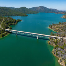
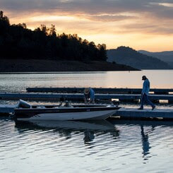
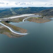
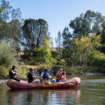
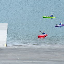
 Lake Oroville Water Operations The Department of Water Resources (DWR) continues releases from Lake Oroville to manage storage levels along with water quality and flows through the Sacramento-San Joaquin Delta. Total releases to the Feather River amount to 5,000 cubic feet per second (cfs), with adjustments being made as needed. Over the past week, inflows into Lake Oroville have been in the range of 3,600 to 4,000 cfs and are projected to be lower for the coming week. DWR is currently using the main spillway for water releases to manage storage within the Oroville complex and maintain Feather River temperature levels during ongoing river valve outlet system work near the Hyatt Powerplant. When the main spillway is not in use water may still be seen on the main spillway outlet as the seals on the eight radial gates are not designed to be watertight. The gate seals do not play a role in the structural integrity of the gates, which continue to operate as intended. DWR periodically maintains and adjusts the seals during low-reservoir conditions to improve their sealing capability. The radial gates were also last inspected and tested in Dec. 2022. Visitors to Oroville Dam may also notice minor amounts of water flowing from drains built into the emergency spillway. As the reservoir level has increased, water flow from the drains has increased, which is normal and expected with the emergency spillway design. The dam and emergency spillway continue to operate as intended. Driftwood and other floating debris on Lake Oroville are expected due to continued water inflows from tributaries and a high lake level, in combination with past wildfires impacting the watershed. Since January, DWR and California Department of Parks and Recreation (State Parks) staff have been collecting, containing, and pulling pieces of wood out of the lake and away from boat launch ramps using boom lines. However, boaters, water skiers, and other water recreationists should take precautions when operating boats on Lake Oroville and should remain alert for floating debris. The Lake Oroville reservoir is the largest storage facility in the State Water Project (SWP) and supports environmental and water delivery needs to 27 million Californians and reduces flood risks to downstream communities. DWR continues to closely monitor lake levels and will adjust releases accordingly to optimize operations for water storage and environmental protection while allowing for carryover storage into next year. 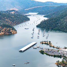 A RESTORATIVE WINTER At only 29 percent capacity in December 2022, the Lake Oroville reservoir has made an astounding recovery thanks to numerous atmospheric rivers that delivered heavy amounts of rain and snow to California this winter. Lake Oroville gained more than 2.5 million acre-feet of water after Dec. 1, bringing the reservoir to its full capacity – a marked difference in just seven months. See the difference in water levels between Dec. 21, 2022, when the reservoir was at 29 percent capacity, to July 3, 2023, with Lake Oroville at 99 percent capacity. It’s a welcome sight! 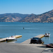 OROVILLE RECREATION A full reservoir delivers numerous opportunities for water recreation at Lake Oroville and is also a prime location to beat 100-degree weather. Water enthusiasts were out in full force at Lake Oroville during the week of July 4. Whether you enjoy swimming, boating, kayaking, jet skiing, fishing, or several other water activities, don’t miss your opportunity to relax and recreate at the lake! The marinas at Bidwell Canyon and Lime Saddle are open daily and provide a variety of services such as a shuttle and boat rentals. DWR, State Parks, and the California Department of Fish and Wildlife maintain over 92 miles of trails in the Oroville area. An interactive map of recreation facilities, including open boat ramps, and their permitted uses (hike, bike, horse, multi) is available on DWR’s Lake Oroville Recreation webpage. A paper trail map is available at various locations, including most entrance kiosks and the Visitor Center. The Lake Oroville Visitor Center is open Monday through Friday between 9 a.m. and 5 p.m. The Visitor Center offers numerous educational exhibits, a theater featuring videos about the building of Oroville Dam, walking and hiking trails, and a 47-foot-tall observation tower providing unsurpassed panoramic views. 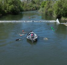 FEATHER RIVER FISH MONITORING STATION DWR is continuing construction activities for a fish monitoring station project in the Feather River in Oroville. The fish monitoring station will provide information on abundance, run timing, and origin (hatchery or natural) of steelhead and Chinook salmon populations that will be used to improve management of these fish populations in the lower Feather River. Work began in June with ongoing installation of a solar panel system along the bank of the Feather River. This week, crews also began in-water work for installation of the fish monitoring station weir that will stretch across the Feather River. Installation of the structure may be complete as early as July 21, but may extend longer due to elevated water conditions in the low-flow channel. Once installed, river users can easily pass over the floating structure using a modified passage panel. Informational signs will be posted at boat launches and near the monitoring station to assist river users in navigating over the structure. Those in more portable water vessels also have the option to use the riverbank and walk around the monitoring station. The structure is being installed along the low-flow channel of the Feather River approximately 6.5 miles downstream of the Feather River Fish Hatchery, 4.5 miles downstream of the Riverbend Boat Ramp, and 1.5 miles upstream of the Thermalito Afterbay River Outlet Boat Ramp.  CAMPING AT LAKE OROVILLE The summer months invite everyone to get outside and enjoy the benefits of longer daylight hours. However, summer heat can make recreating outdoors tiring, which makes Lake Oroville the perfect place for your next camping adventure. The Lake Oroville State Recreation Area boasts 167 miles of shoreline and numerous tent, trailer or boat camping sites operated by State Parks. With the lake a short distance away, campers can cool off in the refreshing water one minute and grill some burgers on a barbecue the next. Lake Oroville is also home to floating campsites and boat-in campgrounds for those looking to spend more time on the water. Reserve a camping site at https://reservecalifornia.com or contact State Parks at (800) 444-7275. 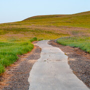 WALK INTO WELLNESS
Join State Parks for a guided, meditative walk around the Lake Oroville State Recreation Area that promotes health and wellness. Free walks focus on calming reflections and enlightening exercises while immersed in the beauty of nature. Sturdy shoes and a water bottle are recommended for participants. The last wellness walk is scheduled from 8 a.m. to 10 a.m. on Sunday, July 16 at Bidwell Canyon; meet at the Toll House Museum. CURRENT LAKE OPERATIONS Lake Oroville is at 894 feet elevation and storage is approximately 3.45 million acre-feet (MAF), which is 98 percent of its total capacity and 136 percent of the historical average. Feather River releases are at 5,000 cfs today to meet downstream Delta water quality and outflow. Flows through the City of Oroville were increased to 1,500 cfs and releases from the Thermalito Afterbay Outlet (Outlet) are at 3,500 cfs for a total of 5,000 cfs downstream of the Outlet. With increasing temperatures additional flow fluctuations may occur next week through the City of Oroville. DWR continues to assess releases to the Feather River daily. The public can track precipitation, snow, reservoir levels, and more at the California Data Exchange Center. The Lake Oroville gage station is identified as “ORO”. All data as of midnight 7/13/2023. 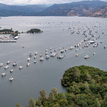 Lake Oroville Water Operations Winter storms and spring snowmelt filled the Lake Oroville reservoir to capacity, an increase of more than 2.5 million acre-feet of water since Dec. 1. The Department of Water Resources (DWR) continues releases from Lake Oroville through the Hyatt Powerplant and Thermalito Afterbay River Outlet. Total releases to the Feather River amount to 3,000 cubic feet per second (cfs), with adjustments being made to manage storage levels along with water quality and flows through the Sacramento-San Joaquin Delta. Over the past week, inflows into Lake Oroville have been in the range of 2,800 to 3,700 cfs and are projected to be in the same range for the coming week. DWR may intermittently use the main spillway this summer for water releases to manage storage within the Oroville complex or maintain Feather River temperature levels during ongoing river valve outlet system work near the Hyatt Powerplant. When the main spillway is not in use water may still be seen on the main spillway outlet as the seals on the eight radial gates are not designed to be watertight. The gate seals do not play a role in the structural integrity of the gates, which continue to operate as intended. DWR periodically maintains and adjusts the seals during low-reservoir conditions to improve their sealing capability. The radial gates were also last inspected and tested in Dec. 2022. Visitors to Oroville Dam may also notice minor amounts of water flowing from drains built into the emergency spillway. As the reservoir level has increased, water flow from the drains has increased, which is normal and expected with the emergency spillway design. The dam and emergency spillway continue to operate as intended. Driftwood and other floating debris on Lake Oroville are expected due to continued water inflows from tributaries and a high lake level, in combination with past wildfires impacting the watershed. Since January, DWR and California Department of Parks and Recreation (State Parks) staff have been collecting, containing, and pulling pieces of wood out of the lake and away from boat launch ramps using boom lines. However, boaters, water skiers, and other water recreationists should take precautions when operating boats on Lake Oroville and should remain alert for floating debris. The Lake Oroville reservoir is the largest storage facility in the State Water Project (SWP) and supports environmental and water delivery needs to 27 million Californians and reduces flood risks to downstream communities. DWR continues to closely monitor lake levels and will adjust releases accordingly to optimize operations for water storage and environmental protection while allowing for carryover storage into next year.  CAMPING AT LAKE OROVILLE The summer months invite everyone to get outside and enjoy the benefits of longer daylight hours. However, summer heat can make recreating outdoors tiring, which makes Lake Oroville the perfect place for your next camping adventure. The Lake Oroville State Recreation Area boasts 167 miles of shoreline and numerous tent, trailer or boat camping sites operated by State Parks. With the lake a short distance away, campers can cool off in the refreshing water one minute and grill some burgers on a barbecue the next. Lake Oroville is also home to floating campsites and boat-in campgrounds for those looking to spend more time on the water. Reserve a camping site at https://reservecalifornia.com or contact State Parks at (800) 444-7275. OROVILLE DAM CITIZENS ADVISORY COMMISSION The California Natural Resources Agency hosted a virtual Oroville Dam Citizens Advisory Commission meeting today via Zoom. In addition to public comment, presentations on dam safety projects and fiscal year 2023–24 Oroville Dam facility expenditures were provided. The Commission also continued conversations about inundation maps. The Citizens Advisory Commission is a forum for questions and feedback from the communities surrounding Oroville Dam. For information on the meeting, please visit https://bit.ly/OrovilleCAC. A transcript of the meeting will be available on the webpage in the coming weeks.  WALK INTO WELLNESS Join State Parks for a guided, meditative walk around the Lake Oroville State Recreation Area that promotes health and wellness. Free walks focus on calming reflections and enlightening exercises while immersed in the beauty of nature. Sturdy shoes and a water bottle are recommended for participants. The last wellness walk is scheduled from 8 a.m. to 10 a.m. on Sunday, July 16 at Bidwell Canyon; meet at the Toll House Museum. 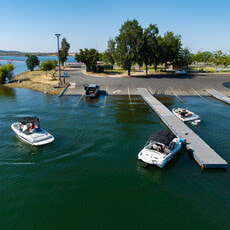 OROVILLE RECREATION
The Lake Oroville Visitor Center is open Monday through Friday between 9 a.m. and 5 p.m. The Visitor Center offers numerous educational exhibits, a theater featuring videos about the building of Oroville Dam, walking and hiking trails, and a 47-foot-tall observation tower providing unsurpassed panoramic views. DWR, State Parks, and the California Department of Fish and Wildlife maintain over 92 miles of trails in the Oroville area. An interactive map of recreation facilities, including open boat ramps, and their permitted uses (hike, bike, horse, multi) is available on DWR’s Lake Oroville Recreation webpage. A paper trail map is available at various locations, including most entrance kiosks and the Visitor Center. The marinas at Bidwell Canyon and Lime Saddle are open daily and provide a variety of services such as a shuttle and boat rentals. CURRENT LAKE OPERATIONS Lake Oroville is at 897 feet elevation and storage is approximately 3.49 million acre-feet (MAF), which is 99 percent of its total capacity and 133 percent of the historical average. Feather River releases were increased to 3,000 cfs today to meet downstream Delta water quality and outflow. Flows through the City of Oroville will be decreasing over the weekend. By Sunday, flows through the City of Oroville will be at 650 cfs and releases from the Thermalito Afterbay Outlet (Outlet) will be at 2,350 cfs for a total of 3,000 cfs downstream of the Outlet. With increasing temperatures additional flow fluctuations may occur next week through the City of Oroville. DWR continues to assess releases to the Feather River daily. The public can track precipitation, snow, reservoir levels, and more at the California Data Exchange Center. The Lake Oroville gage station is identified as “ORO”. All data as of midnight 7/6/2023.  Lake Oroville Water Operations Winter storms and spring snowmelt have filled the Lake Oroville reservoir to capacity, an increase of more than 2.5 million acre-feet of water since Dec. 1. Although the Department of Water Resources (DWR) stopped releasing water on June 17 from the main spillway, water may still be seen on the main spillway outlet as the seals on the eight radial gates are not designed to be watertight. The gate seals do not play a role in the structural integrity of the gates, which continue to operate as intended. DWR periodically maintains and adjusts the seals during low-reservoir conditions to improve their sealing capability. The radial gates were also last inspected and tested in Dec. 2022. While water is not being released from the main spillway, water is being released from Lake Oroville through Hyatt Powerplant and the Thermalito Afterbay River Outlet. Water releases to the Feather River via these options are at 3,500 cfs, with adjustments being made as needed to ensure continued storage space in Lake Oroville for snowmelt runoff. Lake Oroville is full and at this level there is also the potential for some waves to splash over the crest of the emergency spillway if we experience any particularly windy days. While unlikely, DWR will be monitoring for the potential of any wave runup that might splash over the crest of the emergency spillway. Wave splash will not affect the integrity of the emergency spillway structure or Oroville Dam. Visitors to Oroville Dam may also notice minor amounts of water flowing from drains built into the emergency spillway. As the reservoir level has increased, water flow from the drains has increased, which is normal and expected with the emergency spillway design. The dam and emergency spillway continue to operate as intended. Driftwood and other floating debris on Lake Oroville are expected due to continued water inflows from tributaries and a high lake level, in combination with past wildfires impacting the watershed. Since January, DWR and California Department of Parks and Recreation (State Parks) staff have been collecting, containing, and pulling pieces of wood out of the lake and away from boat launch ramps using boom lines. However, boaters, water skiers, and other water recreationists should take precautions when operating boats on Lake Oroville and should remain alert for floating debris. The Lake Oroville reservoir is the largest storage facility in the State Water Project (SWP) and supports environmental and water delivery needs to 27 million Californians and reduces flood risks to downstream communities. DWR continues to closely monitor lake levels and will adjust releases accordingly to optimize operations for water storage and environmental protection while allowing for carryover storage into next year. 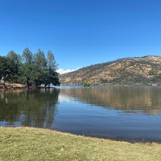 SWIM BEACHES The summer months have officially arrived and temperatures in Northern California will continue to climb beyond the moderate weather we’ve experienced so far. While Lake Oroville offers ample water opportunities for boating, kayaking or wakeboarding, the Lake Oroville State Recreation Area (LOSRA) and Oroville Wildlife Area (OWA) also offer several family-friendly swim beaches that are excellent locations to beat the heat. Swim beaches within the LOSRA and OWA provide shallow wading and swimming opportunities for visitors of all ages with nearby restroom facilities. Some locations also include picnic benches and barbecue facilities that are perfect for hosting a fun family gathering. Beat the heat this summer and relax at one of our recreation facility swim beaches – Loafer Creek at Lake Oroville, Monument Hill or Larkin Road at the Thermalito Afterbay, or the South or North Thermalito Forebay.  FOURTH OF JULY IN OROVILLE Celebrate our nation’s independence on July 4 with a spectacular fireworks show at the Oroville Airport located at 225 Chuck Yeager Way. Patriotic festivities begin Saturday, July 1 with a fly-in and car show at the airport from 8 a.m. to 3 p.m. The free event includes a pancake breakfast, food vendors, art and craft vendors, remote-controlled helicopter demonstrations, airplanes, classic cars, and low riders. On Tuesday, July 4, kick off the holiday with a meet and greet with Oroville’s first responders from 9 a.m. to 1 p.m. at the Oroville Airport. Later that evening, the Fourth of July fireworks show begins 30 minutes after sunset. The Oroville Chamber of Commerce’s website has several maps highlighting prime locations for fireworks viewing so you can plan ahead.  OROVILLE RECREATION
The Lake Oroville Visitor Center is open Monday through Friday between 9 a.m. and 5 p.m. The Visitor Center offers numerous educational exhibits, a theater featuring videos about the building of Oroville Dam, walking and hiking trails, and a 47-foot-tall observation tower providing unsurpassed panoramic views. DWR, State Parks, and the California Department of Fish and Wildlife maintain over 92 miles of trails in the Oroville area. Paved trails at the Lake Oroville Visitor Center, Spillway Day Use Area, and at the North Forebay Day Use Area offer accessible trails with only slight elevation changes. Other trails, such as the Potter's Ravine Trail near Oroville Dam, offer steep elevation changes to challenge hikers and mountain bikers. The Saddle Dam Trailhead has facilities for equestrians, including a large parking area to accommodate horse trailers, water troughs, and hitching posts, and easy access to trails designated for hikers and horses. An interactive map of recreation facilities, including open boat ramps, and their permitted uses (hike, bike, horse, multi) is available on DWR’s Lake Oroville Recreation webpage. A paper trail map is available at various locations, including most entrance kiosks and the Visitor Center. The marinas at Bidwell Canyon and Lime Saddle are open daily and provide a variety of services such as a shuttle and boat rentals. CURRENT LAKE OPERATIONS Lake Oroville is at 899 feet elevation and storage is approximately 3.53 million acre-feet (MAF), which is 100 percent of its total capacity and 130 percent of the historical average. The Feather River releases are at 3,500 cubic feet per second (cfs). Flows through the City of Oroville are 650 cfs with 2,850 cfs released from the Thermalito Afterbay Outlet (Outlet) for a total of 3,500 cfs downstream of the Outlet. DWR continues to assess releases to the Feather River daily. The public can track precipitation, snow, reservoir levels, and more at the California Data Exchange Center. The Lake Oroville gage station is identified as “ORO”. All data as of midnight 6/22/2023.  Lake Oroville Water Operations The Department of Water Resources (DWR) continues to make releases from Lake Oroville using the main spillway at Oroville Dam. Ongoing releases ensure continued storage space in Lake Oroville for spring runoff from snowmelt and are closely coordinated with the U.S. Army Corps of Engineers and downstream water operators. Total releases to the Feather River amount to 4,000 cubic feet per second (cfs) with 2,200 cfs being routed down the low-flow channel which flows through the City of Oroville. An additional 1,800 cfs is being released from the Thermalito Afterbay River Outlet, located 5 miles downstream from Oroville. Since Dec. 1, Lake Oroville’s storage has increased more than 230 feet and gained over 2.4 million acre-feet of water. Lake Oroville is currently at 98 percent capacity and is expected to reach full capacity this month. As Oroville reaches full capacity there will be the potential for some waves to splash over the crest of the emergency spillway if we experience any particularly windy days. While unlikely, DWR will be monitoring for the potential of any wave runup that might splash over the crest of the emergency spillway. Wave splash will not affect the integrity of the emergency spillway structure or Oroville Dam. Visitors to Oroville Dam may also notice minor amounts of water flowing from drains built into the emergency spillway. As the reservoir level has increased, water flow from the drains has increased, which is normal and expected with the emergency spillway design. The dam and emergency spillway continue to operate as intended. Driftwood and other floating debris on Lake Oroville are expected due to continued water inflows from tributaries and a high lake level, in combination with past wildfires impacting the watershed. Since January, State officials and marina partners have been collecting, containing, and pulling pieces of wood out of the lake and away from boat launch ramps using boom lines. However, boaters, water skiers, and other water recreationists should take precautions when operating boats on Lake Oroville and should remain alert for floating debris. The Lake Oroville reservoir is the largest storage facility in the State Water Project (SWP) and supports environmental and water delivery needs to 27 million Californians and reduces flood risks to downstream communities. DWR continues to closely monitor lake levels and will adjust releases accordingly to optimize operations for water storage and environmental protection while allowing for carryover storage into next year. 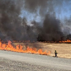 THERMALITO FOREBAY VEGETATION MANAGEMENT For the third straight year, DWR, CAL FIRE/Butte County Fire Department, and the California Department of Parks and Recreation (State Parks) will conduct a series of prescribed burns around the Thermalito Forebay. The targeted two-week window for this project is June 3 to June 17 and depends on favorable weather conditions. The Forebay Vegetation Management Project (VMP) was first conducted in 2021 to improve valley grassland and vernal pool habitat. Invasive annual grasses and other invasive species like the yellow star thistle degrade native grasslands and fire is a valuable tool to combat this degradation. Because invasive species have seeds and dry material called thatch that build up on the soil, it is important to burn the same area multiple years in a row. When completed during the right stage in these species' growth cycle, the control burns eradicate the current crop, reduce the dry residual thatch, and decreases the spread of seeds. The area has seen a significant decline in the volume of invasive grasses and star thistles since the project began. The project burns also allow DWR to continue post-fire studies on vernal pool habitat. CAL FIRE/Butte County Fire Department will also be conducting prescribed burns near the Rabe Road Shooting Range during this period. Smoke from the control burns will be highly visible in the Oroville area. 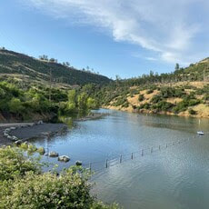 CAR-TOP BOAT LAUNCHES State Parks has closed the Nelson Bar Car-Top Boat Launch due to high lake water levels that have inundated the parking lot, which is at an elevation between 891 to 895 feet. The parking lot and car-top launch ramp will reopen again once Lake Oroville water levels recede. High water levels have also permitted the Vinton Gulch Car-Top Boat Launch to reopen. The car-top boat launch may be accessed via State Route 70 and Cherokee Road along the west branch of the north fork arm of Lake Oroville. WALK INTO WELLNESSJoin State Parks for a series of guided, meditative walks around the Lake Oroville State Recreation Area that promote health and wellness. These free walks focus on calming reflections and enlightening exercises while immersed in the beauty of nature. Sturdy shoes and a water bottle are recommended for participants. Wellness walks are scheduled from 8 a.m. to 10 a.m. on the following dates and locations:
 OROVILLE RECREATION
The Lake Oroville Visitor Center is open Monday through Friday between 9 a.m. and 5 p.m. The Visitor Center offers numerous educational exhibits, a theater featuring videos about the building of Oroville Dam, and a 47-foot-tall observation tower providing unsurpassed panoramic views. DWR, State Parks, and CDFW maintain over 92 miles of trails in the Oroville area. An interactive map of recreation facilities, including open boat ramps, and their permitted uses is available on DWR’s Lake Oroville Recreation webpage. A paper trail map is available at various locations, including most entrance kiosks and the Visitor Center. The marinas at Bidwell Canyon and Lime Saddle are open daily and provide a variety of services such as a shuttle and boat rentals. CURRENT LAKE OPERATIONS Lake Oroville is at 895 feet elevation and storage is approximately 3.47 million acre-feet (MAF), which is 98 percent of its total capacity and 123 percent of the historical average. The Feather River releases are at 4,000 cubic feet per second (cfs). Flows through the City of Oroville are 2,200 cfs with 1,800 cfs released from the Thermalito Afterbay Outlet (Outlet) for a total of 4,000 cfs downstream of the Outlet. DWR continues to assess releases to the Feather River daily. The public can track precipitation, snow, reservoir levels, and more at the California Data Exchange Center. The Lake Oroville gage station is identified as “ORO”. All data as of midnight 6/2/2023.  Lake Oroville Water Operations The Department of Water Resources (DWR) continues to make releases from Lake Oroville using the main spillway at Oroville Dam. Ongoing releases ensure continued storage space in Lake Oroville for spring runoff from snowmelt and are closely coordinated with the U.S. Army Corps of Engineers and downstream water operators. Total releases to the Feather River amount to 9,000 cubic feet per second (cfs) with 2,200 cfs being routed down the low-flow channel which flows through the City of Oroville. An additional 6,800 cfs is being released from the Thermalito Afterbay River Outlet, located 5 miles downstream from Oroville. DWR continues to closely monitor lake levels and will adjust releases accordingly to optimize operations for water storage and environmental protection while allowing for carryover storage into next year. Driftwood and other floating debris on Lake Oroville are expected due to continued water inflows from tributaries and a high lake level, in combination with past wildfires impacting the watershed. Since January, State officials and marina partners have been collecting, containing, and pulling pieces of wood out of the lake and away from boat launch ramps using boom lines. However, boaters, water skiers, and other water recreationists should take precautions when operating boats on Lake Oroville and should remain alert for floating debris. Since Dec. 1, Lake Oroville’s storage has increased approximately 230 feet and gained over 2.44 million acre-feet of water. Lake Oroville is currently at 96 percent capacity and is expected to reach full capacity in June. The Lake Oroville reservoir is the largest storage facility in the State Water Project (SWP) and supports environmental and water delivery needs to 27 million Californians and reduces flood risks to downstream communities. 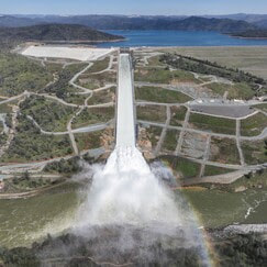 STATE WATER PROJECT ADAPTS TO CLIMATE CHANGE As California experiences more extreme swings between wet and dry periods, DWR continues to deploy innovative forecasting and water management strategies for the State Water Project (SWP) to adapt to California’s changing climate. The SWP delivers an average of 2.4 million acre-feet of water to more than 27 million Californians and 750,000 acres of farmland while providing multiple benefits, such as flood control, hydropower generation, fish and wildlife protections, drinking water quality, and recreational opportunities. Releases from Lake Oroville, the largest SWP reservoir, also keep salt water from intruding into the Delta and contaminating drinking water or water used to irrigate crops. The SWP diverts and stores surplus water during wet periods and distributes water to 29 water contractors – all public agencies that have contracts for water that is distributed to farms, homes, and industry. Annual water supply deliveries depend on rainfall runoff, snowpack, existing water in storage facilities, Delta pumping capacity, and environmental regulations. The State Water Project is required to follow more than one regulation when releasing water from SWP reservoirs, such as Lake Oroville. Releases from Lake Oroville meet requirements set forth by the State Water Resources Control Board, U.S. Army Corps of Engineers, California Department of Fish and Wildlife (CDFW), Federal Energy Regulatory Commission, and National Marine Fisheries Service. The SWP release decisions are also coordinated with the U.S. Bureau of Reclamation which operates the Central Valley Project, since many requirements must be jointly met by the two projects. DWR continues to explore several improvements to existing SWP infrastructure that can improve water supply reliability, water quality, water temperature control, and increased electricity integration of water supply infrastructure. Read more about DWR’s strategy for adapting to climate change. 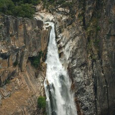 FEATHER FALLS A popular excursion at Lake Oroville during high-water level periods is to take a boat trip to the upper end of the Middle Fork Arm to view Feather Falls, a Yosemite-style waterfall of exquisite beauty. Along the way, there are many smaller waterfalls to see including some that tumble directly into Lake Oroville such as Bean Creek and Frey Creek. Bring a picnic lunch, a camera, and don’t forget your fishing pole. There are unlimited bass fishing opportunities along the route and trout fishing can also be good where the cold mountain streams enter the lake. 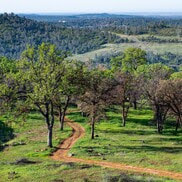 WALK INTO WELLNESS Join the California Department of Parks and Recreation (State Parks) for a series of guided, meditative walks around the Lake Oroville State Recreation Area that promote health and wellness. These free walks focus on calming reflections and enlightening exercises while immersed in the beauty of nature. Sturdy shoes and a water bottle are recommended for participants. Wellness walks are scheduled from 8 a.m. to 10 a.m. on the following dates and locations:
 OROVILLE RECREATION
The Lake Oroville Visitor Center is open Monday through Friday between 9 a.m. and 5 p.m. The Visitor Center offers numerous educational exhibits, a theater featuring videos about the building of Oroville Dam, and a 47-foot-tall observation tower providing unsurpassed panoramic views. DWR, State Parks, and CDFW maintain over 92 miles of trails in the Oroville area. An interactive map of recreation facilities, including open boat ramps, and their permitted uses is available on DWR’s Lake Oroville Recreation webpage. A paper trail map is available at various locations, including most entrance kiosks and the Visitor Center. The marinas at Bidwell Canyon and Lime Saddle are open daily and provide a variety of services such as a shuttle and boat rentals. CURRENT LAKE OPERATIONS Lake Oroville is at 891 feet elevation and storage is approximately 3.4 million acre-feet (MAF), which is 96 percent of its total capacity and 122 percent of the historical average. The Feather River releases are at 9,000 cubic feet per second (cfs). Flows through the City of Oroville are 2,200 cfs with 6,800 cfs released from the Thermalito Afterbay Outlet (Outlet) for a total of 9,000 cfs downstream of the Outlet. DWR continues to assess releases to the Feather River daily. The public can track precipitation, snow, reservoir levels, and more at the California Data Exchange Center. The Lake Oroville gage station is identified as “ORO”. All data as of midnight 5/25/2023. 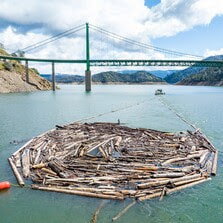 Lake Oroville Water Releases Continue The Department of Water Resources (DWR) continues to make releases from Lake Oroville using the main spillway at Oroville Dam. Ongoing releases ensure continued storage space in Lake Oroville for spring runoff from snowmelt and are closely coordinated with the U.S. Army Corps of Engineers and downstream water operators. Total releases to the Feather River amount to 13,000 cubic feet per second (cfs) with 5,650 cfs being routed down the low-flow channel which flows through the City of Oroville. An additional 7,350 cfs is being released from the Thermalito Afterbay River Outlet, located 5 miles downstream from Oroville. DWR continues to closely monitor lake levels and will adjust releases accordingly to optimize operations for water storage and environmental protection while allowing for carryover storage into next year. Driftwood and other floating debris at the state recreation area are expected due to continued water inflows from tributaries and a high lake level, in combination with past wildfires impacting the watershed. Since January, State officials and marina partners have been collecting, containing, and pulling pieces of wood out of the lake and away from boat launch ramps using boom lines. However, boaters, water skiers, and other water recreationists should take precautions when operating boats on Lake Oroville and should remain alert for floating debris. Since Dec. 1, Lake Oroville’s storage has increased approximately 230 feet and gained over 2.4 million acre-feet of water. Lake Oroville is currently at 96 percent capacity and is expected to reach full capacity this spring. The Lake Oroville reservoir is the largest storage facility in the State Water Project (SWP) and supports environmental and water delivery needs to 27 million Californians and reduces flood risks to downstream communities. 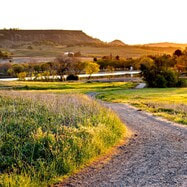 WALK INTO WELLNESS Join the California Department of Parks and Recreation (State Parks) for a series of guided, meditative walks around the Lake Oroville State Recreation Area that promote health and wellness. These free walks focus on calming reflections and enlightening exercises while immersed in the beauty of nature. Sturdy shoes and a water bottle are recommended for participants. Wellness walks are scheduled from 8 a.m. to 10 a.m. on the following dates and locations:
 HOURS EXTENDED FOR SPILLWAY DAY-USE AREA As the summer months approach and daylight hours linger, the Spillway Boat Ramp and Day Use Area is now open from 5 a.m. to 11 p.m. All vehicles and trailers are subject to inspection by the California Highway Patrol (CHP) for security purposes. There are five other boat ramps at Lake Oroville that are open 24 hours a day and do not entail CHP inspections: Bidwell Canyon, Loafer Point, Loafer Creek, Lime Saddle and Enterprise.  WATER SAFETY MONTH The State Water Project’s (SWP) reservoirs located throughout California will welcome the upcoming summer months with high water levels. Heavy storms this past winter will also bring fast flows and cold temperatures to rivers and streams as mountain snow melts. When recreating at SWP facilities, you should always keep water safety a top priority and stay alert for cold, fast, and fluctuating water conditions. As part of Water Safety Month, keep these water safety tips in mind to have a fun and safe summer:
 OROVILLE RECREATION
DWR, State Parks, and CDFW maintain over 92 miles of trails in the Oroville area. Paved trails at the Lake Oroville Visitor Center, Spillway Day Use Area, and at the North Forebay Day Use Area offer accessible trails with only slight elevation changes. Other trails, such as the Brad Freeman Trail near Oroville Dam, offer steep elevation changes to challenge hikers and mountain bikers. The Saddle Dam Trailhead has facilities for equestrians including a large parking area to accommodate horse trailers, water troughs, and hitching posts, and easy access to trails designated for hikers and horses. An interactive map of recreation facilities, including open boat ramps, and their permitted uses is available on DWR’s Lake Oroville Recreation webpage. A paper trail map is available at various locations, including most entrance kiosks and the Visitor Center. The marinas at Bidwell Canyon and Lime Saddle are open daily and provide a variety of services such as a shuttle and boat rentals. The Lake Oroville Visitor Center is open Monday through Friday between 9 a.m. and 5 p.m. The Visitor Center offers numerous educational exhibits, a theater featuring videos about the building of Oroville Dam, and a 47-foot-tall observation tower providing unsurpassed panoramic views. CURRENT LAKE OPERATIONS Lake Oroville is at 890 feet elevation and storage is approximately 3.38 million acre-feet (MAF), which is 96 percent of its total capacity and 122 percent of the historical average. The Feather River releases are at 13,000 cubic feet per second (cfs). Flows through the City of Oroville are 5,650 cfs with 7,350 cfs released from the Thermalito Afterbay Outlet (Outlet) for a total of 13,000 cfs downstream of the Outlet. DWR continues to assess releases to the Feather River daily. The public can track precipitation, snow, reservoir levels, and more at the California Data Exchange Center. The Lake Oroville gage station is identified as “ORO”. All data as of midnight 5/18/2023. 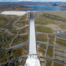 Lake Oroville Water Releases Continue The Department of Water Resources (DWR) continues to make releases from Lake Oroville using the main spillway at Oroville Dam. Ongoing releases ensure continued storage space in Lake Oroville for spring runoff from snowmelt and are closely coordinated with the U.S. Army Corps of Engineers and downstream water operators. Total releases to the Feather River amount to 15,000 cubic feet per second (cfs) with 3,500 cfs being routed down the low-flow channel which flows through the City of Oroville. An additional 11,500 cfs is being released from the Thermalito Afterbay River Outlet, located 5 miles downstream from Oroville. DWR continues to closely monitor lake levels and will adjust releases accordingly. Visitors to Oroville Dam may also notice minor amounts of water flowing from drains built into the emergency spillway. As the reservoir level has increased, water flow from the drains has increased, which is normal and expected with the emergency spillway design. The dam and emergency spillway continue to operate as intended. Since Dec. 1, Lake Oroville’s storage has increased more than 210 feet and gained over 2 million acre-feet of water. The Lake Oroville reservoir is the largest storage facility in the State Water Project (SWP) and supports environmental and water delivery needs to 27 million Californians and reduces flood risks to downstream communities. DWR continues to monitor lake levels, weather forecasts, and mountain snow levels to optimize operations for water storage and environmental protection while allowing for carryover storage into next year.  HEALTHY KIDS DAY Join the Oroville YMCA on Saturday, April 29 for a celebration of art in the community and Healthy Kids Day activities. Local Oroville schools and community groups will be showcasing performances in dance, theater, and music with visual arts and hands-on workshops. DWR’s Lake Oroville Visitor Center Guides will be promoting Healthy Kids Day activities with an information booth from 10 a.m. to 2 p.m. on how much water it takes to grow a healthy salad. A fun, hands-on activity will feature a coloring sheet that kids can cut out and glue together to create a healthy take-home salad! As we approach the summer recreation season, DWR will also be providing information on water safety for pools, rivers, and lakes. Stop by the Oroville Convention Center located at 1200 Myers Street from 10 a.m. to 5 p.m. to partake in a day of family-friendly activities. 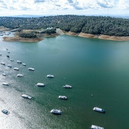 WATER ALLOCATIONS INCREASED DWR announced April 20 another increase in the forecasted State Water Project (SWP) deliveries this year. With reservoirs nearing capacity and snowmelt runoff starting to occur, DWR now expects to deliver 100 percent of requested water supplies, up from 75 percent announced in March. This water will be delivered throughout the year to the SWP’s 29 public water agencies that serve 27 million Californians and 750,000 acres of farmland. The last time the SWP allocated 100 percent was in 2006. San Luis Reservoir in Merced County, which holds water supply for both the SWP and U.S. Bureau of Reclamation’s Central Valley Project (CVP), is now full. Additionally, Lake Oroville, the SWP’s largest reservoir, and SWP reservoirs in Southern California are expected to be full by the end of May. Statewide, reservoir storage is at 105 percent of average for this date. “Water supply conditions and careful management of reservoir operations during this extreme winter allows DWR to maximize water deliveries while enhancing protections for the environment,” said DWR Director Karla Nemeth. “DWR is moving and storing as much water as possible to the benefit of communities, agriculture, and the environment.” More information on SWP allocations may be found in the press release.  OROVILLE RECREATION
DWR, State Parks, and CDFW maintain over 92 miles of trails in the Oroville area. Paved trails at the Lake Oroville Visitor Center, Spillway Day Use Area, and at the North Forebay Day Use Area offer accessible trails with only slight elevation changes. Other trails, such as the Brad Freeman Trail near Oroville Dam, offer steep elevation changes to challenge hikers and mountain bikers. The Saddle Dam Trailhead has facilities for equestrians, including a large parking area to accommodate horse trailers, water troughs, and hitching posts, and easy access to trails designated for hikers and horses. An interactive map of recreation facilities, including open boat ramps, and their permitted uses (hike, bike, horse, multi) is available on DWR’s Lake Oroville Recreation webpage. A paper trail map is available at various locations, including most entrance kiosks and the Visitor Center. Lake Oroville is one of the State Water Project’s premier recreational destinations and one of California’s best fishing spots. The lake provides both warm-water and cold-water fisheries. Below the Oroville Dam, the Thermalito Forebay, Thermalito Afterbay and the Feather River offer additional excellent fishing opportunities for Chinook salmon and steelhead. The marinas at Bidwell Canyon and Lime Saddle are open daily and provide a variety of services such as a shuttle and boat rentals. CURRENT LAKE OPERATIONS Lake Oroville is at 874 feet elevation and storage is approximately 3.15 million acre-feet (MAF), which is 89 percent of its total capacity and 119 percent of the historical average. The Feather River releases are at 15,000 cubic feet per second (cfs). Flows through the City of Oroville are 3,500 cfs with 11,500 cfs released from the Thermalito Afterbay Outlet (Outlet) for a total of 15,000 cfs downstream of the Outlet. DWR continues to assess releases to the Feather River daily. The public can track precipitation, snow, reservoir levels, and more at the California Data Exchange Center. The Lake Oroville gage station is identified as “ORO”. All data as of midnight 4/20/2023. 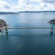 Lake Oroville Water Releases Continue The Department of Water Resources (DWR) continues to make releases from Lake Oroville using the main spillway at Oroville Dam. Ongoing releases ensure continued storage space in Lake Oroville for spring runoff from rain and snowmelt and are closely coordinated with the U.S. Army Corps of Engineers and downstream water operators. Total releases to the Feather River amount to 7,500 cubic feet per second (cfs) with 1,000 cfs being routed down the low-flow channel which flows through the City of Oroville. An additional 6,500 cfs is being released from the Thermalito Afterbay River Outlet, located 5 miles downstream from Oroville. DWR continues to closely monitor lake levels and will adjust releases accordingly. Releases to the Feather River may be increased temporarily in the coming weeks to assist with fish planting operations. Since Dec. 1, Lake Oroville’s storage has increased approximately 200 feet and gained just under 2 million acre-feet of water. The Lake Oroville reservoir is the largest storage facility in the State Water Project (SWP) and supports environmental and water delivery needs to 27 million Californians and reduces flood risks to downstream communities. DWR continues to monitor lake levels, weather forecasts, and mountain snow levels to optimize operations for water storage and environmental protection while allowing for carryover storage into next year. 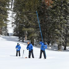 DWR CONDUCTS APRIL SNOW SURVEY DWR conducted the fourth snow survey of the season at Phillips Station on April 3. The manual survey recorded 126.5 inches of snow depth and a snow water equivalent of 54 inches, which is 221 percent of average for this location on April 3. The snow water equivalent measures the amount of water contained in the snowpack and is a key component of DWR’s water supply forecast. DWR’s electronic readings from 130 snow sensors placed throughout the state indicate the statewide snowpack’s snow water equivalent is 61.1 inches, or 237 percent of average for this date. This year’s April 1 result from the statewide snow sensor network is higher than any other reading since the snow sensor network was established in the mid-1980s. Before the network was established, the 1983 April 1 statewide summary from manual snow course measurements was 227 percent of average. The 1952 April 1 statewide summary for snow course measurements was 237 percent of average. “This year’s result will go down as one of the largest snowpack years on record in California,” said Sean de Guzman, manager of DWR’s Snow Surveys and Water Supply Forecasting Unit. “While 1952’s snow course measurements showed a similar result, there were fewer snow courses at that time, making it difficult to compare to today’s results. Because additional snow courses were added over the years, it is difficult to compare results accurately across the decades with precision, but this year’s snowpack is definitely one of the biggest the state has seen since the 1950s.” For more information about the April snow survey, read DWR’s press release.  EARTH WEEK ACTIVITIES Celebrate Earth Week at the Lake Oroville Visitor Center April 17-21. Join our guides for fun, family-friendly activities throughout the week. Each day is an opportunity to show your love for our planet and its precious water through free fun activities, engaging story times, movies, or crafts. Located at 917 Kelly Ridge Rd in Oroville, the Visitor Center is open Monday through Friday from 9 a.m. to 5 p.m.
 OROVILLE RECREATION
DWR, State Parks, and CDFW maintain over 92 miles of trails in the Oroville area. Paved trails at the Lake Oroville Visitor Center, Spillway Day Use Area, and at the North Forebay Day Use Area offer accessible trails with only slight elevation changes. Other trails, such as the Brad Freeman Trail near Oroville Dam, offer steep elevation changes to challenge hikers and mountain bikers. The Saddle Dam Trailhead has facilities for equestrians, including a large parking area to accommodate horse trailers, water troughs, and hitching posts, and easy access to trails designated for hikers and horses. An interactive map of recreation facilities, including open boat ramps, and their permitted uses (hike, bike, horse, multi) is available on DWR’s Lake Oroville Recreation webpage. A paper trail map is available at various locations, including most entrance kiosks and the Visitor Center. The marinas at Bidwell Canyon and Lime Saddle are open daily and provide a variety of services such as a shuttle and boat rentals. CURRENT LAKE OPERATIONS Lake Oroville is at 860 feet elevation and storage is approximately 2.94 million acre-feet (MAF), which is 83 percent of its total capacity and 115 percent of the historical average. Dry weather conditions will be returning to the area next week. The Feather River releases are at 7,500 cubic feet per second (cfs). Flows through the City of Oroville are 1,000 cfs with 6,500 cfs released from the Thermalito Afterbay Outlet (Outlet) for a total of 7,500 cfs downstream of the Outlet. DWR continues to assess releases to the Feather River daily. The public can track precipitation, snow, reservoir levels, and more at the California Data Exchange Center. The Lake Oroville gage station is identified as “ORO”. All data as of midnight 4/6/2023.  DWR Releasing Water from Lake Oroville The Department of Water Resources (DWR) continues to make flood control releases from Lake Oroville using the main spillway at Oroville Dam. These flood control releases are a result of high water inflows to Lake Oroville from a series of recent storms, with the purpose of protecting downstream communities. As of today, total releases to the Feather River amount to 35,000 cubic feet per second (cfs) with 23,000 cfs being routed down the low-flow channel which flows through the City of Oroville. An additional 12,000 cfs is being released from the Thermalito Afterbay River Outlet, located 5 miles downstream from Oroville. These releases from Lake Oroville are being made in coordination with the U.S. Army Corps of Engineers and downstream water operators for flood control protection to downstream communities. DWR continues to closely monitor lake inflow levels and will adjust releases accordingly. Due to increased releases from Oroville Dam’s main spillway, DWR and local partners have closed Oro Dam Blvd. E. between Rusty Dusty Road and Canyon Drive in Butte County. Higher releases from the main spillway cause excessive water spray across the road and reduce driver visibility, requiring a closure for public safety. Motorists may still access Oroville Dam and the State Recreation Area via State Route 162 (Oro Quincy Highway) and Canyon Drive. This section of Oro Dam Blvd. E. will remain closed to traffic until releases from the main spillway are reduced to level that is safe for motorists. Since Dec. 1 Lake Oroville’s storage has increased approximately 200 feet and gained just under 2 million acre-feet of water. The Lake Oroville reservoir is the largest storage facility in the State Water Project and supports environmental and water delivery needs to 27 million Californians and reduces flood risks to downstream communities. DWR continues to monitor lake levels, weather forecasts, and mountain snow levels to optimize operations for flood control, water storage, and environmental protection while allowing for carryover storage into next year. Enterprise Boat Ramp Reopens The Enterprise boat ramp is now open for use thanks to continued rising lake levels. Open for water elevations above 842 feet, it has a two-lane paved ramp and boarding pad. Located on the south fork arm of Lake Oroville, Enterprise is also a popular place for swimming and fishing. Check the status of Lake Oroville boat and cartop ramps on the California Department of Parks and Recreation’s (State Parks) website.  OROVILLE WILDFLOWER & NATURE FESTIVAL The Feather River Recreation & Park District (FRRPD) is hosting its annual Wildflower & Nature Festival at Riverbend Park in Oroville on Saturday, April 1 from 10 a.m. to 4 p.m. Festival admission is free with the event highlighting the area’s natural resources and handmade Butte County products. Activities and entertainment will be available for all ages including children’s crafts, river kayak tours, live music, food trucks, and a beer and wine garden. Make sure to stop by DWR’s booth for information about the Lake Oroville Visitor Center, Lake Oroville State Recreation Area and a felt craft activity for kids – making a California poppy. More information about the Wildflower & Nature Festival is available on FRRPD’s website.  SPEED BOAT TIME TRIALS Speed boat time trials are returning to the Thermalito Afterbay March 24 through March 26. The event requires the closure of the southern portion of the Afterbay (south of Highway 162), the Monument Hill boat ramp, and the Larkin Road cartop boat launch on March 25 and March 26. The Wilbur Road boat ramp and areas north of Hwy 162 will remain open for public use during the boating event. The event is hosted by the Northern California Outboard Association and East Bay Boat Club and will feature a mile-long course. Time trial events are expected Saturday and Sunday between 8 a.m. and 5 p.m. depending on weather and water conditions. More information about the event can be found on the American Power Boat Association webpage. 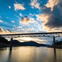 OROVILLE RECREATION
DWR, the California Department of Parks and Recreation, and CDFW maintain over 92 miles of trails in the Oroville area. Paved trails at the Lake Oroville Visitor Center and at the North Forebay Day Use Area offer accessible trails with only slight elevation changes. Other trails, such as the Brad Freeman Trail near Oroville Dam, offer steep elevation changes to challenge hikers and mountain bikers. The Saddle Dam Trailhead has facilities for equestrians, including a large parking area to accommodate horse trailers, water troughs, and hitching posts, and easy access to trails designated for hikers and horses. An interactive map of recreation facilities, including open boat ramps, and their permitted uses (hike, bike, horse, multi) is available on DWR’s Lake Oroville Recreation webpage. The marinas at Bidwell Canyon and Lime Saddle are open daily and provide a variety of services such as a shuttle and boat rentals. The Lake Oroville Visitor Center is open Monday through Friday between 9 a.m. and 5 p.m. The Visitor Center offers numerous educational exhibits, a theater featuring videos about the building of Oroville Dam, walking and hiking trails, and a 47-foot-tall observation tower providing unsurpassed panoramic views. CURRENT LAKE OPERATIONS Lake Oroville is at 860 feet elevation and storage is approximately 2.95 million acre-feet (MAF), which is 83 percent of its total capacity and 125 percent of the historical average. Wet weather is once again anticipated Sunday through mid-week. The Feather River releases increased to 35,000 cubic feet per second (cfs) today. Flows through the City of Oroville are 23,000 cfs with 12,000 cfs released from the Thermalito Afterbay Outlet (Outlet) for a total of 35,000 cfs downstream of the Outlet. DWR continues to assess releases to the Feather River daily. The public can track precipitation, snow, reservoir levels, and more at the California Data Exchange Center. The Lake Oroville gage station is identified as “ORO”. All data as of midnight 3/16/2023. 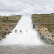 Update on Lake Oroville Operations
The Department of Water Resources (DWR) is alerting Butte County and Oroville residents of the impending closure of Oro Dam Blvd. E. between Rusty Dusty Road and Canyon Drive due to increased releases from the main spillway at Oroville Dam. Beginning at 9 a.m. on Friday, March 17, Oro Dam Blvd. E. will be closed to traffic prior to increasing spillway releases in stages from 25,000 cubic feet per second (cfs) to 35,000 cfs. When releases from the main spillway exceed 30,000 cfs, water spray can reduce driver visibility on the roadway, requiring a closure for public safety. Motorists may still access Oroville Dam and the State Recreation Area via State Route 162 (Oro Quincy Highway) and Canyon Drive. Oro Dam Blvd. E. will remain closed to traffic until releases from the main spillway are reduced. In addition, flows through the low-flow channel within the City of Oroville will begin increasing starting at 10 a.m. Friday. Flows in the low-flow channel will increase gradually from 13,000 cfs to 23,000 cfs by 4 p.m. Releases from Lake Oroville are being made in coordination with the U.S. Army Corps of Engineers and downstream water operators for flood control protection to downstream communities. DWR continues to closely monitor lake inflow levels and will adjust releases accordingly. The information below reflects current reservoir level estimates. Forecasts can change quickly and may affect the estimates provided.
|
Archives
April 2024
Categories
All
|
 RSS Feed