 Lake Oroville Reaches Full Capacity Two Years in a Row While the new water year began with warm and dry conditions, the Feather River watershed received enough precipitation and snowpack runoff in the first months of 2024 to fill Lake Oroville to capacity for the second year in a row. The Department of Water Resources (DWR) continues to adjust Lake Oroville water releases as needed to account for increasing or decreasing inflows into the reservoir and maintain flood protection for downstream communities. Releases are closely coordinated with the U.S. Army Corps of Engineers and other water operators and adjusted as needed to maintain balance throughout the water system. With Lake Oroville at full capacity, windy periods are likely to cause water to splash onto and over the crest of the emergency spillway. This will result in minor surface wetting of the downstream side of the emergency spillway crest and the very upper sections of the splash pad. Visitors to Oroville Dam may also notice minor amounts of water flowing from drains built into the emergency spillway. Both conditions are normal and expected given the emergency spillway design. The dam and emergency spillway continue to operate as intended. The information below reflects current reservoir level estimates. Forecasts can change quickly and may affect the estimates provided.
Total releases to the Feather River amount to 9,500 cfs with 650 cfs being routed down the Low Flow Channel through the City of Oroville. An additional 8,850 cfs is being released from the Thermalito Afterbay River Outlet, located 5 miles downstream from Oroville. Feather River releases will be incrementally reduced to 8,500 cfs by Monday, May 13. DWR continues to assess Feather River releases daily. As the largest storage facility in the State Water Project, Lake Oroville helps provide water to 27 million Californians and 750,000 acres of farmland, while providing flood protection to downstream communities along with environmental and recreation benefits. Spring is an important time for water project operators to fill reservoirs like Lake Oroville ahead of dry months. It also is an important migration window for many native fish species. DWR is using the best available science to protect fish species. However, SWP operations have faced significant restrictions in the Delta this year that have impacted the ability to capture and store the water needed if California sees a return to drought conditions. DWR continues to monitor Lake Oroville levels and mountain snow levels to optimize water storage while meeting environmental requirements and allowing for carryover storage into next year.  Feather Falls A popular excursion at Lake Oroville during high-water level periods is to take a boat trip to the upper end of the Middle Fork Arm to view Feather Falls, a Yosemite-style waterfall of exquisite beauty. Along the way, there are many smaller waterfalls to see including some that tumble directly into Lake Oroville such as Bean Creek and Frey Creek. Bring a picnic lunch, a camera, and don’t forget your fishing pole. There are unlimited bass fishing opportunities along the route and trout fishing can also be good in areas where cold mountain streams enter the lake.  Gold Flat Loop Campground Reopens The California Department of Parks and Recreation (State Parks) has reopened the Bidwell Canyon Gold Flat Loop Campground at the Lake Oroville State Recreation Area following extensive ADA site upgrades. In addition to repaving campground access roads, three of the 37 tent/RV camping sites received accessibility upgrades with parking stalls and a clear path of travel to accessible restroom and shower facilities. Upgrades to the campground also included new water and sewer facilities to complement new power hookups that were completed in recent years. The Gold Flat Loop Campground is conveniently located near the popular Bidwell Canyon Marina and provides nearby access to the Bidwell Canyon Trail (hiking/biking) and the Dan Beebe Trail (hiking/equestrian). With Lake Oroville at full capacity, now is the perfect time to reserve a campsite and enjoy the numerous recreation opportunities available at Lake Oroville. Book your Lake Oroville stay at reservecalifornia.com.  Oroville Recreation
Staffed by knowledgeable guides, the Visitor Center features interpretive displays on Oroville Dam, area geology, wildlife and habitat, hydroelectric power, and cultural and historical artifacts. View videos in the theater about the construction of Oroville Dam, walk or hike along nearby trails, and visit the 47-foot-tall observation tower that provides unsurpassed panoramic views of surrounding areas. Free guided tours for school and community groups are available by reservation. Parking and admission to the Visitor Center are free. DWR, State Parks, and the California Department of Fish and Wildlife (CDFW) maintain over 92 miles of trails in the Oroville area. An interactive map of recreation facilities, including open trails and their permitted uses (hike, bike, horse, multi), is available on DWR’s Lake Oroville Recreation webpage. A paper trail map is available at various locations, including most entrance kiosks and the Lake Oroville Visitor Center. Lake Oroville is one of the State Water Project’s premier recreational destinations and one of California’s best fishing spots. The lake provides both warm-water and cold-water fisheries and is a popular destination for bass tournaments. Below the Oroville Dam, the Thermalito Afterbay and the Feather River offer additional excellent fishing opportunities. The marinas at Bidwell Canyon and Lime Saddle are open daily and provide a variety of services including a convenience store, gas, and boat rentals. Upstream migrating fish totals through the Feather River Fish Monitoring Station between Jan. 1 and May 5 are:
Current Lake OperationsLake Oroville is at 899 feet elevation and storage is approximately 3.52 million acre-feet (MAF), which is 100 percent of its total capacity and 128 percent of the historical average. Feather River flows are at 650 cfs through the City of Oroville with 8,850 cfs being released from the Thermalito Afterbay River Outlet (Outlet) for a total Feather River release of 9,500 cfs downstream. Feather River releases will be incrementally reduced to 8,500 cfs by Monday, May 13. DWR continues to assess Feather River releases daily. The public can track precipitation, snow, reservoir levels, and more at the California Data Exchange Center. The Lake Oroville gage station is identified as “ORO.” All data as of midnight 5/9/2024. Know someone who would like to receive Community Updates? They can email their request to oroville@water.ca.gov.
0 Comments
 Storage Increasing at Lake Oroville During the winter and early spring months, flood control releases from Oroville Dam ensure the safety of the City of Oroville and downstream communities by reserving storage space to capture high storm inflows while permitting controlled and coordinated releases from the dam. As the warm, summer months approach and rain and snowstorms driven by atmospheric rivers wane, the Department of Water Resources (DWR) transitions from performing flood control releases at Oroville Dam to capturing as much water in the reservoir as possible, while still meeting water delivery and environmental requirements. Throughout April, DWR decreased total releases from Lake Oroville to account for reduced inflows into the reservoir, while optimizing storage for the benefit of water supply, recreation, and fish and wildlife enhancement. DWR coordinates releases closely with the U.S. Army Corps of Engineers and other water operators and adjusts releases as needed to maintain balance throughout the water system. As Lake Oroville approaches full capacity there is the potential for some waves to splash over the crest of the emergency spillway if we experience any particularly windy days. Visitors to Oroville Dam may also notice minor amounts of water flowing from drains built into the emergency spillway, which is normal and expected with the emergency spillway design. The dam and emergency spillway continue to operate as intended. The information below reflects current reservoir level estimates. Forecasts can change quickly and may affect the estimates provided.
Total releases to the Feather River amount to 5,500 cfs with 650 cfs being routed down the Low Flow Channel through the City of Oroville. An additional 4,850 cfs is being released from the Thermalito Afterbay River Outlet, located 5 miles downstream from Oroville. Total Feather River releases may be increased over the weekend to account for higher reservoir inflows from weekend precipitation. DWR continues to assess Feather River releases daily. Lake Oroville is the largest storage facility in the State Water Project, providing flood protection while supporting environmental and water delivery needs to 27 million Californians. DWR continues to monitor lake levels and mountain snow levels to optimize water storage while meeting environmental requirements and allowing for carryover storage into next year.  Blue-Green Algae Monitoring DWR’s environmental scientists began monitoring for blue-green algae and their toxins last week within the Oroville-Thermalito Complex and at Davis, Frenchman, and Antelope Lakes (Upper Feather River lakes). Monitoring occurs during the summer months with water samples taken at various locations regularly, which are sent to a lab for toxin analysis. There are currently no harmful algal bloom (HAB) advisories for Lake Oroville, Upper Feather River lakes, the Thermalito Forebay, or the Thermalito Afterbay. Blue-green algae (cyanobacteria) is a natural component of ecosystems. Under certain conditions, including warmer temperatures and increased nutrient loads, algae can grow rapidly causing “blooms.” Algal blooms sometimes produce toxins that can be harmful to people and animals. Algal blooms can make the water appear green, blue, or brown in color. Seeing colors, mats, foam, scum, or paint-like streaks in the water may indicate a bloom is present. Keep animals and children away from the water when a suspected bloom is present and report blooms immediately to the California Regional Water Quality Control Board. If elevated levels of cyanobacteria toxins are found while testing, DWR staff will work with California’s Regional Water Quality Control Board and recreation area managers to notify the public and post advisory signs at affected waterbodies. To learn more about HABs, or to report a HAB visit the Water Board’s website. Oroville Recreation Advisory Committee The Oroville Recreation Advisory Committee (ORAC) met May 3 at the Southside Oroville Community Center. ORAC was established by the Federal Energy Regulatory Commission (FERC) to review and provide recreation plan recommendations to DWR for the Oroville Facilities. The 13-member committee is made up of representatives from state and local government, recreation groups, and business and community organizations. To obtain a summary of the meeting, send a request to oroville@water.ca.gov.  Feather Fiesta Days For more than 70 years, Feather Fiesta Days has been Oroville’s premier hometown celebration. Festivities are scheduled this weekend Friday, May 3 through Sunday, May 5 with a large variety of activities. Get the party started today with the Gold Rush Car Show, Kiwanis Kiddies Day Parade, and Feather River Recreation & Park District's Concert in the Park. Then head to downtown Oroville on Saturday for a pancake breakfast, Feather Fiesta Days Parade, craft fair, and vendor and food booths. Stop by DWR’s booth in downtown Oroville between 10 a.m. and 4 p.m. on Saturday. We’ll be sharing information about Lake Oroville recreation areas and have a fun drawing activity. Decorate our banner with sayings or drawings that represent what you love about the Feather River. We’ll be displaying your beautiful banner artwork at the Lake Oroville Visitor Center for the next few weeks. Learn more about scheduled Feather Fiesta Days activities at visitoroville.com. Extended Hours for Spillway Day-Use Area With the approaching summer months and extended daylight hours, the Spillway Boat Ramp and Day Use Area are now open from 5 a.m. to 11 p.m. All vehicles and trailers are subject to inspection by the California Highway Patrol (CHP) for security purposes. There are five other boat ramps at Lake Oroville that are open 24 hours a day and do not entail CHP inspections: Bidwell Canyon, Loafer Point, Loafer Creek, Lime Saddle, and Enterprise.  Oroville Recreation
Staffed by knowledgeable guides, the Visitor Center features interpretive displays on Oroville Dam, area geology, wildlife and habitat, hydroelectric power, and cultural and historical artifacts. View videos in the theater about the construction of Oroville Dam, walk or hike along nearby trails, and visit the 47-foot-tall observation tower that provides unsurpassed panoramic views of surrounding areas. Free guided tours for school and community groups are available by reservation. Parking and admission to the Visitor Center are free. DWR, State Parks, and CDFW maintain over 92 miles of trails in the Oroville area. An interactive map of recreation facilities, including open trails and their permitted uses (hike, bike, horse, multi), is available on DWR’s Lake Oroville Recreation webpage. A paper trail map is available at various locations, including most entrance kiosks and the Lake Oroville Visitor Center. Lake Oroville is one of the State Water Project’s premier recreational destinations and one of California’s best fishing spots. The lake provides both warm-water and cold-water fisheries and is a popular destination for bass tournaments. Below the Oroville Dam, the Thermalito Afterbay and the Feather River offer additional excellent fishing opportunities. The marinas at Bidwell Canyon and Lime Saddle are open daily and provide a variety of services including a convenience store, gas, and boat rentals. Upstream migrating fish totals through the Feather River Fish Monitoring Station between Jan. 1 and April 28 are:
Current Lake OperationsLake Oroville is at 897 feet elevation and storage is approximately 3.49 million acre-feet (MAF), which is 99 percent of its total capacity and 127 percent of the historical average. Feather River flows are at 650 cfs through the City of Oroville with 3,350 cfs being released from the Thermalito Afterbay River Outlet (Outlet) for a total Feather River release of 4,000 cfs downstream. Total Feather River releases may be increased over the weekend to account for higher reservoir inflows from weekend precipitation. DWR continues to assess Feather River releases daily. The public can track precipitation, snow, reservoir levels, and more at the California Data Exchange Center. The Lake Oroville gage station is identified as “ORO.” All data as of midnight 5/2/2024. Know someone who would like to receive Community Updates? They can email their request to oroville@water.ca.gov.  Storage Increasing at Lake Oroville During the winter and early spring months, flood control releases from Oroville Dam ensure the safety of the City of Oroville and downstream communities by reserving storage space to capture high storm inflows while permitting controlled and coordinated releases from the dam. As the warm, summer months approach and rain and snowstorms driven by atmospheric rivers wane, the Department of Water Resources (DWR) transitions from performing flood control releases at Oroville Dam to capturing as much water in the reservoir as possible, while still meeting water delivery and environmental requirements. Throughout April, DWR has decreased total releases from Lake Oroville to account for reduced inflows into the reservoir, while optimizing storage for the benefit of water supply, recreation, and fish and wildlife enhancement. DWR coordinates releases closely with the U.S. Army Corps of Engineers and other water operators and adjusts releases as needed to maintain balance throughout the water system. The information below reflects current reservoir level estimates. Forecasts can change quickly and may affect the estimates provided.
Total releases to the Feather River amount to 4,000 cfs with 650 cfs being routed down the Low Flow Channel through the City of Oroville. An additional 3,350 cfs is being released from the Thermalito Afterbay River Outlet, located 5 miles downstream from Oroville. Total Feather River releases may be increased over the weekend to meet downstream water quality requirements. DWR continues to assess Feather River releases daily. Lake Oroville is the largest storage facility in the State Water Project, providing flood protection while supporting environmental and water delivery needs to 27 million Californians. DWR continues to monitor lake levels and mountain snow levels to optimize water storage while meeting environmental requirements and allowing for carryover storage into next year.  DWR Supports New Well for Berry Creek School Destroyed by Fire Almost four years ago, the community of Berry Creek was destroyed by the North Complex Fire leaving just a few homes standing and the local elementary school burned to the ground. Thanks to funding provided in 2022 by DWR's Small Community Drought Relief Program, construction is underway to drill a new well and install a water system to support students when they return to school in the future. Learn more about how DWR is helping the Berry Creek community: https://youtu.be/Th_e9rkmRr0 Extended Hours for Spillway Day-Use Area With the approaching summer months and extended daylight hours, the Spillway Boat Ramp and Day Use Area will be open from 5 a.m. to 11 p.m. starting Wednesday, May 1. All vehicles and trailers are subject to inspection by the California Highway Patrol (CHP) for security purposes. There are five other boat ramps at Lake Oroville that are open 24 hours a day and do not entail CHP inspections: Bidwell Canyon, Loafer Point, Loafer Creek, Lime Saddle, and Enterprise. Oroville Recreation Advisory Committee The Oroville Recreation Advisory Committee (ORAC) will hold a meeting on Friday, May 3 at 10 a.m. at the Southside Oroville Community Center located at 2959 Lower Wyandotte Road, Oroville, CA, 95966. ORAC was established by the Federal Energy Regulatory Commission (FERC) to review and provide recreation plan recommendations for Oroville Facilities owned by the Department of Water Resources (DWR). The 13-member committee is made up of representatives from state and local government, recreation groups, and business and community organizations.  Feather Fiesta Days For more than 70 years, Feather Fiesta Days has been Oroville’s premier hometown celebration. This year, festivities will be held Friday, May 3 through Sunday, May 5 with a large variety of activities. Get the party started on Friday with the Gold Rush Car Show, Kiwanis Kiddies Day Parade, and Feather River Recreation & Park District's Concert in the Park. Then head to downtown Oroville on Saturday for a pancake breakfast, Feather Fiesta Days Parade, craft fair, and vendor and food booths. Stop by DWR’s booth in downtown Oroville between 10 a.m. and 4 p.m. on Saturday. We’ll be sharing information about Lake Oroville recreation areas and have a fun drawing activity. Decorate our banner with sayings or drawings that represent what you love about the Feather River. We’ll be displaying your beautiful banner artwork at the Lake Oroville Visitor Center for the next few weeks. Learn more about scheduled Feather Fiesta Days activities at visitoroville.com.  Oroville Recreation
DWR, State Parks, and CDFW maintain over 92 miles of trails in the Oroville area. An interactive map of recreation facilities, including open trails and their permitted uses (hike, bike, horse, multi), is available on DWR’s Lake Oroville Recreation webpage. A paper trail map is available at various locations, including most entrance kiosks and the Lake Oroville Visitor Center. Staffed by knowledgeable guides, the Visitor Center features interpretive displays on Oroville Dam, area geology, wildlife and habitat, hydroelectric power, and cultural and historical artifacts. View videos in the theater about the construction of Oroville Dam, walk or hike along nearby trails, and visit the 47-foot-tall observation tower that provides unsurpassed panoramic views of surrounding areas. Free guided tours for school and community groups are available by reservation. Parking and admission to the Visitor Center are free. Lake Oroville is one of the State Water Project’s premier recreational destinations and one of California’s best fishing spots. The lake provides both warm-water and cold-water fisheries and is a popular destination for bass tournaments. Below the Oroville Dam, the Thermalito Afterbay and the Feather River offer additional excellent fishing opportunities. The marinas at Bidwell Canyon and Lime Saddle are open daily and provide a variety of services including a convenience store, gas, and boat rentals. Upstream migrating fish totals through the Feather River Fish Monitoring Station between Jan. 1 and April 20 are:
Current Lake OperationsLake Oroville is at 889 feet elevation and storage is approximately 3.37 million acre-feet (MAF), which is 95 percent of its total capacity and 125 percent of the historical average. Feather River flows are at 650 cfs through the City of Oroville with 3,350 cfs being released from the Thermalito Afterbay River Outlet (Outlet) for a total Feather River release of 4,000 cfs downstream. Total Feather River releases may be increased over the weekend to meet downstream water quality requirements. DWR continues to assess Feather River releases daily. Visitors to Oroville Dam may also notice minor amounts of water flowing from drains built into the emergency spillway, which is normal and expected with the emergency spillway design. The dam and emergency spillway continue to operate as intended. The public can track precipitation, snow, reservoir levels, and more at the California Data Exchange Center. The Lake Oroville gage station is identified as “ORO.” All data as of midnight 4/25/2024. Know someone who would like to receive Community Updates? They can email their request to oroville@water.ca.gov.  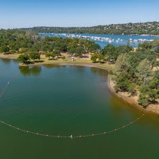 Feather River Pulse Flow to Benefit Migrating Fish With warming temperatures and the mountain snowmelt season underway, the Department of Water Resources (DWR) continues to perform required flood protection releases from Lake Oroville using the Hyatt Powerplant. Releases from Lake Oroville during the spring months help maintain storage capacity in the reservoir to capture runoff, while optimizing storage for the benefit of water supply, recreation, and fish and wildlife enhancement. Over the past week, DWR has further decreased total releases from Lake Oroville to account for reduced inflows into the reservoir. DWR coordinates releases closely with the U.S. Army Corps of Engineers and other water operators and adjusts releases as needed to maintain balance throughout the water system. The information below reflects current reservoir level estimates. Forecasts can change quickly and may affect the estimates provided.
Reductions are in anticipation of a pulse flow, a temporary increase in river flow, which is scheduled to start Tuesday, April 23. Pulse flows benefit migrating fish such as juvenile salmon and steelhead, that are traveling downstream this time of year. Pulse flows increase their survival by increasing the speed at which juvenile salmon and steelhead move downstream, reducing their exposure to predators and potential infection from pathogens. Pulse flows during the winter and spring mimic natural river hydrologic conditions that the salmon and steelhead, along with many other Central Valley riverine species, have adapted to over many eons. Pulse flows were developed in coordination with the California Department of Fish and Wildlife (CDFW) and National Marine Fisheries Service (NMFS) for the benefit of salmon migrating out of the Feather River. During the pulse flow period, the Low Flow Channel will remain at 650 cfs, while total Feather River releases will increase to 6,450 cfs. It is expected that flows will be reduced again by Saturday, April 27. Lake Oroville is the largest storage facility in the State Water Project, providing flood protection while supporting environmental and water delivery needs to 27 million Californians. DWR continues to monitor lake levels, weather forecasts, and mountain snow levels to optimize water storage while meeting environmental requirements and allowing for carryover storage into next year. 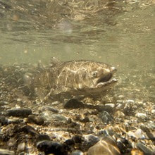 Oroville Wildlife Area Plantings Support Native and Migratory Birds The nearly 12,000-acre Oroville Wildlife Area (OWA) in Butte County is a popular stopping place on the Pacific Flyway for migrating and native birds thanks to its preservation as a wildlife habitat and its proximity to the Thermalito Afterbay and Feather River. Under the management of CDFW, nearly 300 acres of grains, grasses, and flowering plants are sown yearly to provide food (forage), shelter, and nesting cover for migratory and native birds. This spring, CDFW has begun the planting season with 60 acres of sunflower and safflower seeds at 16 different locations around the Thermalito Afterbay. Growing different types of grains, grasses, and flowers provides nutrition for different varieties of birds and wildlife, and safflower and black oil sunflower seeds provide the most energy per pound of any typical birdseed. Both safflowers and sunflowers thrive best in arid climates and dry conditions like those found in the north Sacramento Valley where the OWA is located. However, planting at the OWA does present a challenge due to a lack of an irrigation system. CDFW staff instead utilize dry-land farming techniques including minimal land tilling, wider than normal spacing, and the selection of crops best suited for the environment. CDFW staff have been planting forage in the OWA for over 50 years and have a successful track record of timing the weather with their plowing and seeding activities to provide a welcome bounty of high-energy food and shelter for the Valley’s native birds and migrating visitors. 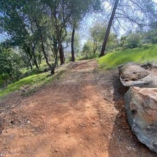 Brad Freeman Trail Reroute Heavy rains caused slope failure along a portion of the Brad Freeman Trail near the Hyatt Powerplant, making a quarter mile long trail section unsafe for public recreation. DWR and the California Department of Parks and Recreation (State Parks) assessed impacts to the trail with a decision ultimately made to reroute the trail for continued recreation use. DWR and State Parks opened the newly rerouted trail this week, which now runs along the north side of Oro Powerhouse Road. The trail reroute provides continuous access to the 41-mile-long Brad Freeman Trail loop, offering multi-use recreation for hiking, biking, and equestrians. The nearest access points to this trail segment are the Diversion Pool parking lot off Oro Powerhouse Road and the Upper Overlook Day Use Area on Canyon Drive. DWR, State Parks, and CDFW maintain over 92 miles of trails in the Oroville area. An interactive map of recreation facilities, including open trails and their permitted uses (hike, bike, horse, multi), is available on DWR’s Lake Oroville Recreation webpage. A paper trail map is available at various locations, including most entrance kiosks and the Lake Oroville Visitor Center. 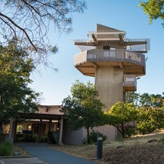 Earth Day Activities Celebrate Earth Day with DWR and the Lake Oroville Visitor Center. Our Visitor Center guides are hosting an Earth Day chalk art event this Saturday, April 20 from 10 a.m. to 3 p.m. Join our staff in creating beautiful chalk art showcasing your love for our planet and its precious resources. The event is open to all ages and chalk will be provided. Located at 917 Kelly Ridge Rd. in Oroville, the Visitor Center is open daily from 9 a.m. to 5 p.m. Staffed by knowledgeable guides, the Visitor Center features interpretive displays on Oroville Dam, area geology, wildlife and habitat, hydroelectric power, and cultural and historical artifacts. View videos in the theater about the construction of Oroville Dam, walk or hike along nearby trails, and visit the 47-foot-tall observation tower that provides unsurpassed panoramic views of surrounding areas. Free guided tours for school and community groups are available by reservation. Parking and admission to the Visitor Center are free.  Oroville Recreation
Lake Oroville is one of the State Water Project’s premier recreational destinations and one of California’s best fishing spots. The lake provides both warm-water and cold-water fisheries and is a popular destination for bass tournaments. Below the Oroville Dam, the Thermalito Afterbay and the Feather River offer additional excellent fishing opportunities. The marinas at Bidwell Canyon and Lime Saddle are open daily and provide a variety of services including a convenience store, gas, and boat rentals. Upstream migrating fish totals through the Feather River Fish Monitoring Station between Jan. 1 and April 11 are:
Current Lake Operations Lake Oroville is at 881 feet elevation and storage is approximately 3.25 million acre-feet (MAF), which is 92 percent of its total capacity and 123 percent of the historical average. Feather River flows are at 650 cfs through the City of Oroville with 4,350 cfs being released from the Thermalito Afterbay River Outlet (Outlet) for a total Feather River release of 5,000 cfs downstream. On Saturday, total Feather River releases will be reduced to 3,500 cfs while maintaining 650 cfs in the Low Flow Channel. Thermalito Afterbay River Outlet releases will be reduced to 2,850 cfs. DWR continues to assess releases to the Feather River daily. Visitors to Oroville Dam may also notice minor amounts of water flowing from drains built into the emergency spillway, which is normal and expected with the emergency spillway design. The dam and emergency spillway continue to operate as intended. The public can track precipitation, snow, reservoir levels, and more at the California Data Exchange Center. The Lake Oroville gage station is identified as “ORO.” All data as of midnight 4/18/2024. California Department of Water Resources715 P Street Sacramento, CA 95814 Call our general information line at 916-820-8142 or email us at oroville@water.ca.gov   Main Spillway Releases Ongoing With warming temperatures and the mountain snowmelt season underway, the Department of Water Resources (DWR) continues to perform required flood protection releases from Lake Oroville using the main spillway and Hyatt Powerplant. Releases from Lake Oroville during the spring months help maintain storage capacity in the reservoir to capture runoff, while optimizing storage for the benefit of water supply, recreation, and fish and wildlife enhancement. Over the past week, DWR decreased total releases from Lake Oroville to account for reduced inflows into the reservoir. DWR coordinates releases closely with the U.S. Army Corps of Engineers and other water operators and adjusts releases as needed to maintain balance throughout the water system. The information below reflects current reservoir level estimates. Forecasts can change quickly and may affect the estimates provided.
Lake Oroville is the largest storage facility in the State Water Project, providing flood protection while supporting environmental and water delivery needs to 27 million Californians. DWR continues to monitor lake levels, weather forecasts, and mountain snow levels to optimize water storage while meeting environmental requirements and allowing for carryover storage into next year.  DWR JOB OPPORTUNITIES IN OROVILLE DWR has numerous job opportunities throughout the State. For those looking for positions based in Butte County, DWR is currently hiring engineers. To view more details about the positions, visit CalCareers. BRAD FREEMAN TRAIL REROUTE Heavy rains caused slope failure along a portion of the Brad Freeman Trail near the Hyatt Powerplant, making a quarter mile long trail section unsafe for public recreation. DWR and the California Department of Parks and Recreation (State Parks) assessed impacts to the trail with a decision ultimately made to reroute the trail for continued recreation use. DWR and State Parks opened the newly rerouted trail this week, which now runs along the north side of Oro Powerhouse Road. The trail reroute provides continuous access to the 41-mile-long Brad Freeman Trail loop, offering multi-use recreation for hiking, biking, and equestrians. The nearest access points to this trail segment are the Diversion Pool parking lot off Oro Powerhouse Road and the Upper Overlook Day Use Area on Canyon Drive. DWR, State Parks, and the California Department of Fish and Wildlife (CDFW) maintain over 92 miles of trails in the Oroville area. An interactive map of recreation facilities, including open trails and their permitted uses (hike, bike, horse, multi), is available on DWR’s Lake Oroville Recreation webpage. A paper trail map is available at various locations, including most entrance kiosks and the Lake Oroville Visitor Center.  EARTH DAY ACTIVITIES Celebrate Earth Day all April with DWR and the Lake Oroville Visitor Center. Our Visitor Center guides are currently hosting a coloring contest for kids ages 5 to 12. Pick up coloring sheets at the Visitor Center and return them or your own original Earth Day artwork by Wednesday, April 17. Winners will have their art displayed publicly in the Visitor Center’s front lobby. In addition, DWR is hosting an Earth Day chalk art event at the Lake Oroville Visitor Center on Saturday, April 20 from 10 a.m. to 3 p.m. Join our guides in creating beautiful chalk art showcasing your love for our planet and its precious resources. The event is open to all ages and chalk will be provided. Located at 917 Kelly Ridge Rd. in Oroville, the Visitor Center is open daily from 9 a.m. to 5 p.m. Staffed by knowledgeable guides, the Visitor Center features interpretive displays on Oroville Dam, area geology, wildlife and habitat, hydroelectric power, and cultural and historical artifacts. View videos in the theater about the construction of Oroville Dam, walk or hike along nearby trails, and visit the 47-foot-tall observation tower that provides unsurpassed panoramic views of surrounding areas. Free guided tours for school and community groups are available by reservation. Parking and admission to the Visitor Center are free. 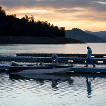 OROVILLE RECREATION Lake Oroville is one of the State Water Project’s premier recreational destinations and one of California’s best fishing spots. The lake provides both warm-water and cold-water fisheries and is a popular destination for bass tournaments. Below the Oroville Dam, the Thermalito Afterbay and the Feather River offer additional excellent fishing opportunities. The marinas at Bidwell Canyon and Lime Saddle are open daily and provide a variety of services including a convenience store, gas, and boat rentals. Upstream migrating fish totals through the Feather River Fish Monitoring Station between Jan. 1 and April 4 are:
CURRENT LAKE OPERATIONS
Lake Oroville is at 875 feet elevation and storage is approximately 3.16 million acre-feet (MAF), which is 89 percent of its total capacity and 122 percent of the historical average. Feather River flows are at 650 cfs through the City of Oroville with 6,350 cfs being released from the Thermalito Afterbay River Outlet (Outlet) for a total Feather River release of 7,000 cfs downstream. DWR continues to assess releases to the Feather River daily. Visitors to Oroville Dam may also notice minor amounts of water flowing from drains built into the emergency spillway, which is normal and expected with the emergency spillway design. The dam and emergency spillway continue to operate as intended. The public can track precipitation, snow, reservoir levels, and more at the California Data Exchange Center. The Lake Oroville gage station is identified as “ORO.” All data as of midnight 4/11/2024.  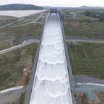 Main Spillway Releases Ongoing As snowmelt season begins, the Department of Water Resources (DWR) continues to perform flood protection releases from Lake Oroville using the main spillway and Hyatt Powerplant. Releases from Lake Oroville during the spring months help maintain storage capacity in the reservoir to capture runoff from mountain snowmelt, while optimizing storage for the benefit of water supply, recreation, and fish and wildlife enhancement. DWR coordinates releases closely with the U.S. Army Corps of Engineers and other water operators and adjusts releases as needed to maintain balance throughout the water system. The information below reflects current reservoir level estimates. Forecasts can change quickly and may affect the estimates provided.
Lake Oroville is the largest storage facility in the State Water Project, providing flood protection while supporting environmental and water delivery needs to 27 million Californians. In 2023, Oroville Dam’s main spillway passed over 2,370,000 acre-feet of water, 67 percent of Lake Oroville’s capacity, with flows as high as 36,000 cfs. The main spillway continues to perform well and operate as designed. DWR continues to monitor lake levels, weather forecasts, and mountain snow levels to optimize water storage while meeting environmental requirements and allowing for carryover storage into next year.  ABOVE AVERAGE SNOWPACK RECORDED DURING APRIL SNOW SURVEY DWR conducted the all-important April snow survey on April 2, the fourth measurement of the season at Phillips Station. The manual survey recorded 64 inches of snow depth and a snow water equivalent of 27.5 inches, which is 113 percent of average for this location. The snow water equivalent measures the amount of water contained in the snowpack and is a key component of DWR’s water supply forecast. The April measurement is critical for water managers as it’s considered the peak snowpack for the season and marks the transition to spring snowmelt into the state’s rivers and reservoirs. DWR’s electronic readings from 130 stations placed throughout the state indicate that the statewide snowpack’s snow water equivalent is 28.6 inches, or 110 percent of the April 1 average, a significant improvement from just 28 percent of average on January 1. California’s reservoirs remain in good shape thanks to state efforts to capture and store as much water as possible from record storms in 2023 and again this season. The State Water Project has increased storage by 700,000 acre-feet at Lake Oroville and by 154,000 acre-feet at San Luis Reservoir since January 1. As of April 2, statewide reservoir levels were at 116 percent of average. Read more about the April snow survey in DWR’s press release.  OROVILLE WILDFLOWER & NATURE FESTIVAL The Feather River Recreation & Park District (FRRPD) is hosting its annual Wildflower & Nature Festival at Riverbend Park in Oroville on Saturday, April 6 from 10 a.m. to 4 p.m. Admission is free to the festival with activities highlighting the area’s natural resources and booths showcasing handmade Butte County products. Activities and entertainment will be available for all ages including children’s crafts, river kayak tours, live music, food trucks, and a beer and wine garden. Make sure to stop by DWR’s booth for information about the Lake Oroville Visitor Center and Lake Oroville State Recreation Area, and a craft activity for kids – making wildflower seed paper. More information about the Wildflower & Nature Festival is available on FRRPD’s website.  EARTH DAY ACTIVITIES Celebrate Earth Day all April with DWR and the Lake Oroville Visitor Center. Our Visitor Center guides are currently hosting a coloring contest for kids ages 5 to 12. Pick up coloring sheets at the Visitor Center and return them or your own original Earth Day artwork by Wednesday, April 17. Winners will have their art displayed publicly in the Visitor Center’s front lobby. In addition, DWR is hosting an Earth Day chalk art event at the Lake Oroville Visitor Center on Saturday, April 20 from 10 a.m. to 3 p.m. Join our guides in creating beautiful chalk art showcasing your love for our planet and its precious resources. The event is open to all ages and chalk will be provided. Located at 917 Kelly Ridge Rd. in Oroville, the Visitor Center is open daily from 9 a.m. to 5 p.m.  OROVILLE RECREATION
DWR, the California Department of Parks and Recreation, and the California Department of Fish and Wildlife (CDFW) maintain over 92 miles of trails in the Oroville area. An interactive map of recreation facilities, including open trails and their permitted uses (hike, bike, horse, multi), is available on DWR’s Lake Oroville Recreation webpage. A paper trail map is available at various locations, including most entrance kiosks and the Lake Oroville Visitor Center. Lake Oroville is one of the State Water Project’s premier recreational destinations and one of California’s best fishing spots. The lake provides both warm-water and cold-water fisheries and is a popular destination for bass tournaments. Below the Oroville Dam, the Thermalito Afterbay and the Feather River offer additional excellent fishing opportunities. The marinas at Bidwell Canyon and Lime Saddle are open daily and provide a variety of services including a convenience store, gas, and boat rentals. Upstream migrating fish totals through the Feather River Fish Monitoring Station between Jan. 1 and March 30 are:
CURRENT LAKE OPERATIONS Lake Oroville is at 873 feet elevation and storage is approximately 3.12 million acre-feet (MAF), which is 88 percent of its total capacity and 123 percent of the historical average. Feather River flows are at 1,000 cfs through the City of Oroville with 9,000 cfs being released from the Thermalito Afterbay River Outlet (Outlet) for a total Feather River release of 10,000 cfs downstream. Total Feather River releases may be reduced over the weekend depending on observed storm impacts. DWR continues to assess releases to the Feather River daily. Visitors to Oroville Dam may also notice minor amounts of water flowing from drains built into the emergency spillway, which is normal and expected with the emergency spillway design. The dam and emergency spillway continue to operate as intended. The public can track precipitation, snow, reservoir levels, and more at the California Data Exchange Center. The Lake Oroville gage station is identified as “ORO.” All data as of midnight 4/4/2024.  Main Spillway Releases Ongoing As snowmelt season begins, the Department of Water Resources (DWR) continues to perform flood protection releases from Lake Oroville using the main spillway and Hyatt Powerplant. Releases from Lake Oroville during the spring months help maintain storage capacity in the reservoir to capture runoff from mountain snowmelt, while optimizing storage for the benefit of water supply, recreation, and fish and wildlife enhancement. DWR coordinates releases closely with the U.S. Army Corps of Engineers and other water operators and adjusts releases as needed to maintain balance throughout the water system. The information below reflects current reservoir level estimates. Forecasts can change quickly and may affect the estimates provided.
Lake Oroville is the largest storage facility in the State Water Project, providing flood protection while supporting environmental and water delivery needs to 27 million Californians. In 2023, Oroville Dam’s main spillway passed over 2,370,000 acre-feet of water, 67 percent of Lake Oroville’s capacity, with flows as high as 36,000 cfs. The main spillway continues to perform well and operate as designed. DWR continues to monitor lake levels, weather forecasts, and mountain snow levels to optimize water storage while meeting environmental requirements and allowing for carryover storage into next year.  OROVILLE WILDFLOWER & NATURE FESTIVAL The Feather River Recreation & Park District (FRRPD) is hosting its annual Wildflower & Nature Festival at Riverbend Park in Oroville on Saturday, April 6 from 10 a.m. to 4 p.m. Admission is free to the festival with activities highlighting the area’s natural resources and booths showcasing handmade Butte County products. Activities and entertainment will be available for all ages including children’s crafts, river kayak tours, live music, food trucks, and a beer and wine garden. Make sure to stop by DWR’s booth for information about the Lake Oroville Visitor Center and Lake Oroville State Recreation Area, and a craft activity for kids – making wildflower seed paper. More information about the Wildflower & Nature Festival is available on FRRPD’s website.  EARTH DAY ACTIVITIES Celebrate Earth Day all April with DWR and the Lake Oroville Visitor Center. Our Visitor Center guides are currently hosting a coloring contest for kids ages 5 to 12. Pick up coloring sheets at the Visitor Center and return them or your own original Earth Day artwork by Wednesday, April 17. Winners will have their art displayed publicly in the Visitor Center’s front lobby. In addition, DWR is hosting an Earth Day chalk art event at the Lake Oroville Visitor Center on Saturday, April 20 from 10 a.m. to 3 p.m. Join our guides in creating beautiful chalk art showcasing your love for our planet and its precious resources. The event is open to all ages and chalk will be provided. Located at 917 Kelly Ridge Rd. in Oroville, the Visitor Center is open daily from 9 a.m. to 5 p.m.  OROVILLE RECREATION
DWR, the California Department of Parks and Recreation, and the California Department of Fish and Wildlife (CDFW) maintain over 92 miles of trails in the Oroville area. An interactive map of recreation facilities, including open trails and their permitted uses (hike, bike, horse, multi), is available on DWR’s Lake Oroville Recreation webpage. A paper trail map is available at various locations, including most entrance kiosks and the Lake Oroville Visitor Center. Lake Oroville is one of the State Water Project’s premier recreational destinations and one of California’s best fishing spots. The lake provides both warm-water and cold-water fisheries and is a popular destination for bass tournaments. Below the Oroville Dam, the Thermalito Afterbay and the Feather River offer additional excellent fishing opportunities. The marinas at Bidwell Canyon and Lime Saddle are open daily and provide a variety of services including a convenience store, gas, and boat rentals. Upstream migrating fish totals through the Feather River Fish Monitoring Station between Jan. 1 and March 18 are:
CURRENT LAKE OPERATIONS Lake Oroville is at 870 feet elevation and storage is approximately 3.08 million acre-feet (MAF), which is 87 percent of its total capacity and 124 percent of the historical average. Feather River flows are at 1,000 cfs through the City of Oroville with 9,000 cfs being released from the Thermalito Afterbay River Outlet (Outlet) for a total Feather River release of 10,000 cfs downstream. DWR continues to assess releases to the Feather River daily. Visitors to Oroville Dam may also notice minor amounts of water flowing from drains built into the emergency spillway, which is normal and expected with the emergency spillway design. The dam and emergency spillway continue to operate as intended. The public can track precipitation, snow, reservoir levels, and more at the California Data Exchange Center. The Lake Oroville gage station is identified as “ORO.” All data as of midnight 3/28/2024. 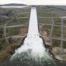 Main Spillway Releases Ongoing The Department of Water Resources (DWR) continues to perform flood protection releases from Lake Oroville using the main spillway and Hyatt Powerplant. Releases from Lake Oroville during the winter and spring months help maintain storage capacity in the reservoir for rain capture and future snowmelt. DWR coordinates releases closely with the U.S. Army Corps of Engineers and other water operators and adjusts releases as needed to account for continuing runoff. The information below reflects current reservoir level estimates. Forecasts can change quickly and may affect the estimates provided.
Crews may also be seen working near the main spillway for several weeks. Sections of the spillway’s underdrain system are being re-inspected to capture additional video footage. In addition, crews will be performing maintenance and repairs to the spillway’s lighting system. Lake Oroville is the largest storage facility in the State Water Project, providing flood protection while supporting environmental and water delivery needs to 27 million Californians. In 2023, Oroville Dam’s main spillway passed over 2,370,000 acre-feet of water, 67 percent of Lake Oroville’s capacity, with flows as high as 36,000 cfs. The main spillway continues to perform well and operate as designed. DWR continues to monitor lake levels, weather forecasts, and mountain snow levels to optimize water storage while meeting environmental requirements and allowing for carryover storage into next year.  TEMPORARY TRAIL CLOSURE IN POTTER’S RAVINE AREA DWR and the California Department of Parks and Recreation (State Parks) have temporarily closed a section of Dead Cow Ravine Trail in the Potter’s Ravine area at the Lake Oroville State Recreation Area. Recreation users can still access the north section of Dead Cow Ravine Trail to Gobbler’s Knob from the Potter’s Point trail. The trail is anticipated to remain closed and be considered an environmentally sensitive area through July 31, 2024. Additionally, wire theft and vandalism have rendered the lighting system within the Brad Freeman Bike Trail’s historic train tunnel inoperable and beyond repair. DWR is designing an entirely new lighting system with construction anticipated in late 2024. The trail will remain open, but users are advised to bring their own light to navigate the train tunnel. DWR, State Parks, and the California Department of Fish and Wildlife (CDFW) maintain over 92 miles of trails in the Oroville area. An interactive map of recreation facilities, including open trails and their permitted uses (hike, bike, horse, multi), is available on DWR’s Lake Oroville Recreation webpage. A paper trail map is available at various locations, including most entrance kiosks and the Lake Oroville Visitor Center. 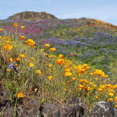 EXPLORE TABLE MOUNTAIN Formed from ancient lava flows, the 3,300-acre North Table Mountain Ecological Reserve is a flat-topped mesa providing spectacular views of the valley below. Following winter rains, fissures along the vast lava caps form natural streams, vernal pools, and waterfalls that cascade off the plateau to the valley below. March is a spectacular time to enjoy miles of hiking trails through the reserve to view an array of wildflowers in bloom and an expansive carpet of green grasses. Cattle grazing on the reserve is used as a management tool to reduce thatch and non-native grass species to benefit native plants. More information about visiting the ecological reserve may be found on the California Department of Fish and Wildlife's (CDFW) website.  OROVILLE RECREATION
The Lake Oroville Visitor Center is open daily from 9 a.m. to 5 p.m. Staffed by knowledgeable guides, the Visitor Center features interpretive displays on Oroville Dam, area geology, wildlife and habitat, hydroelectric power, and cultural and historical artifacts. View videos in the theater about the construction of Oroville Dam, walk or hike along nearby trails, and visit the 47-foot-tall observation tower that provides unsurpassed panoramic views of surrounding areas. Free guided tours for school and community groups are available by reservation. Parking and admission to the Visitor Center are free. Lake Oroville is one of the State Water Project’s premier recreational destinations and one of California’s best fishing spots. The lake provides both warm-water and cold-water fisheries and is a popular destination for bass tournaments. Below the Oroville Dam, the Thermalito Afterbay and the Feather River offer additional excellent fishing opportunities. The marinas at Bidwell Canyon and Lime Saddle are open daily and provide a variety of services including a convenience store, gas, and boat rentals. Upstream migrating fish totals between Jan. 1 and March 9 are:
CURRENT LAKE OPERATIONS Lake Oroville is at 866 feet elevation and storage is approximately 3.03 million acre-feet (MAF), which is 86 percent of its total capacity and 125 percent of the historical average. Feather River flows are at 1,000 cfs through the City of Oroville with 9,000 cfs being released from the Thermalito Afterbay River Outlet (Outlet) for a total Feather River release of 10,000 cfs downstream. Releases may be adjusted over the weekend or early next week to account for storm impacts and higher inflows into Lake Oroville. DWR continues to assess releases to the Feather River daily. Visitors to Oroville Dam may also notice minor amounts of water flowing from drains built into the emergency spillway, which is normal and expected with the emergency spillway design. The dam and emergency spillway continue to operate as intended. The public can track precipitation, snow, reservoir levels, and more at the California Data Exchange Center. The Lake Oroville gage station is identified as “ORO.” All data as of midnight 3/21/2024. 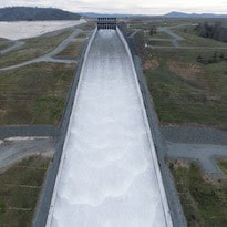 Main Spillway Releases Ongoing The Department of Water Resources (DWR) continues to perform flood protection releases from Lake Oroville using the main spillway and Hyatt Powerplant. Releases from Lake Oroville during the winter and spring months help maintain storage capacity in the reservoir for rain capture and future snowmelt. DWR coordinates releases closely with the U.S. Army Corps of Engineers and other water operators and adjusts releases as needed to account for continuing runoff. The information below reflects current reservoir level estimates. Forecasts can change quickly and may affect the estimates provided.
Crews may also be seen working near the main spillway for several weeks. Sections of the spillway’s underdrain system are being re-inspected to capture additional video footage. In addition, crews will be performing maintenance and repairs to the spillway’s lighting system. Lake Oroville is the largest storage facility in the State Water Project, providing flood protection while supporting environmental and water delivery needs to 27 million Californians. In 2023, Oroville Dam’s main spillway passed over 2,370,000 acre-feet of water, 67 percent of Lake Oroville’s capacity, with flows as high as 36,000 cfs. The main spillway continues to perform well and operate as designed. DWR continues to monitor lake levels, weather forecasts, and mountain snow levels to optimize water storage while meeting environmental requirements and allowing for carryover storage into next year. 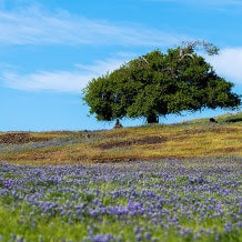 EXPLORE TABLE MOUNTAIN Formed from ancient lava flows, the 3,300-acre North Table Mountain Ecological Reserve is a flat-topped mesa providing spectacular views of the valley below. Following winter rains, fissures along the vast lava caps form natural streams, vernal pools, and waterfalls that cascade off the plateau to the valley below. March is a spectacular time to enjoy miles of hiking trails through the reserve to view an array of wildflowers in bloom and an expansive carpet of green grasses. Cattle grazing on the reserve is used as a management tool to reduce thatch and non-native grass species to benefit native plants. More information about visiting the ecological reserve may be found on the California Department of Fish and Wildlife's (CDFW) website.  THERMALITO AFTERBAY PARTIAL CLOSURE FOR SPEED BOAT TIME TRIALS Speed boat time trials are returning to the Thermalito Afterbay March 16 to March 17. The event requires the closure of the southern portion of the Afterbay (south of Highway 162) and the Monument Hill boat ramp. The Larkin Road cartop boat launch will also be closed the afternoon of Friday, March 15 and will reopen Monday, March 18 in the morning. The Wilbur Road boat ramp and areas north of Hwy 162 will remain open for public use during the boating event. The event is hosted by the Northern California Outboard Association and East Bay Boat Club and will feature a mile-long course. Time trial events are expected Saturday and Sunday between 8 a.m. and 5 p.m. depending on weather and water conditions. More information about the event can be found on the American Power Boat Association webpage.  OROVILLE RECREATION
Trail users on the Brad Freeman Bike Trail that follows the old railroad grade between downtown Oroville and Hyatt Powerplant have long enjoyed the section of trail through the historic train tunnel. Unfortunately, wire theft and vandalism have rendered the train tunnel’s lighting system inoperable and beyond repair. DWR is designing an entirely new lighting system with construction anticipated in late 2024. The trail will remain open, but users are advised to bring their own light to navigate the train tunnel. DWR, the California Department of Parks and Recreation (State Parks), and CDFW maintain over 92 miles of trails in the Oroville area. An interactive map of recreation facilities, including open trails and their permitted uses (hike, bike, horse, multi), is available on DWR’s Lake Oroville Recreation webpage. A paper trail map is available at various locations, including most entrance kiosks and the Lake Oroville Visitor Center. The Lake Oroville Visitor Center is open daily from 9 a.m. to 5 p.m. Staffed by knowledgeable guides, the Visitor Center features interpretive displays on Oroville Dam, area geology, wildlife and habitat, hydroelectric power, and cultural and historical artifacts. View videos in the theater about the construction of Oroville Dam, walk or hike along nearby trails, and visit the 47-foot-tall observation tower that provides unsurpassed panoramic views of surrounding areas. Free guided tours for school and community groups are available by reservation. Parking and admission to the Visitor Center are free. Lake Oroville is one of the State Water Project’s premier recreational destinations and one of California’s best fishing spots. The lake provides both warm-water and cold-water fisheries and is a popular destination for bass tournaments. Below the Oroville Dam, the Thermalito Afterbay and the Feather River offer additional excellent fishing opportunities. The marinas at Bidwell Canyon and Lime Saddle are open daily and provide a variety of services including a convenience store, gas, and boat rentals. Upstream migrating fish totals between Jan. 1 and March 9 are:
CURRENT LAKE OPERATIONS Lake Oroville is at 863 feet elevation and storage is approximately 2.99 million acre-feet (MAF), which is 85 percent of its total capacity and 127 percent of the historical average. Feather River flows are at 1,600 cfs through the City of Oroville with 8,400 cfs being released from the Thermalito Afterbay River Outlet (Outlet) for a total Feather River release of 10,000 cfs downstream. Further changes to flows are planned over the weekend with the low-flow channel being reduced to 1,000 cfs and releases from the Thermalito Afterbay River Outlet being increased to 9,000 cfs by Sunday. DWR continues to assess releases to the Feather River daily. Visitors to Oroville Dam may also notice minor amounts of water flowing from drains built into the emergency spillway, which is normal and expected with the emergency spillway design. The dam and emergency spillway continue to operate as intended. The public can track precipitation, snow, reservoir levels, and more at the California Data Exchange Center. The Lake Oroville gage station is identified as “ORO.” All data as of midnight 3/14/2024. 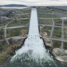 Main Spillway Releases Ongoing The Department of Water Resources (DWR) continues to release water from Lake Oroville using the main spillway and Hyatt Powerplant. Releases from Lake Oroville during the winter and spring months provide flood protection to downstream communities by maintaining storage capacity in the reservoir for rain capture and future snowmelt. DWR coordinates releases closely with the U.S. Army Corps of Engineers and other water operators and adjusts releases as needed to account for continuing runoff. The information below reflects current reservoir level estimates. Forecasts can change quickly and may affect the estimates provided.
Crews may also be seen working near the main spillway for several weeks. Sections of the spillway’s underdrain system are being re-inspected to capture additional video footage. In addition, crews will be performing maintenance and repairs to the spillway’s lighting system. Lake Oroville is the largest storage facility in the State Water Project, providing flood protection while supporting environmental and water delivery needs to 27 million Californians. In 2023, Oroville Dam’s main spillway passed over 2,370,000 acre-feet of water, 67 percent of Lake Oroville’s capacity, with flows as high as 36,000 cfs. The main spillway continues to perform well and operate as designed. DWR continues to monitor lake levels, weather forecasts, and mountain snow levels to optimize water storage while meeting environmental requirements and allowing for carryover storage into next year.  THERMALITO AFTERBAY PARTIAL CLOSURE FOR SPEED BOAT TIME TRIALS Speed boat time trials are returning to the Thermalito Afterbay March 16 to March 17. The event requires the closure of the southern portion of the Afterbay (south of Highway 162) and the Monument Hill boat ramp. The Larkin Road cartop boat launch will also be closed the afternoon of Friday, March 15 and will reopen Monday, March 18 in the morning. The Wilbur Road boat ramp and areas north of Hwy 162 will remain open for public use during the boating event. The event is hosted by the Northern California Outboard Association and East Bay Boat Club and will feature a mile-long course. Time trial events are expected Saturday and Sunday between 8 a.m. and 5 p.m. depending on weather and water conditions. More information about the event can be found on the American Power Boat Association webpage.  FEATHER RIVER FISH HATCHERY STEELHEAD PLANTING The Feather River Fish Hatchery raised approximately 452,000 yearling steelhead trout around 8.5 to 9.5 inches in length for 2024 releases. Around 7,000 steelhead were released in the Thermalito Afterbay the week of Feb. 12 to support recreational fishing. In addition, 1,011 adult male steelhead were released into the Thermalito Afterbay from December to February after they had been spawned at the hatchery. Hatchery-spawned females were released back to the Feather River. Approximately 445,000 steelhead were released into the Feather River at Boyd’s Pump Boat Launch between Feb. 5 and Feb. 13 to meet mitigation requirements. Releasing the young fish further downstream improves their chances of survival. Like the salmon that populate the Feather River, steelhead trout migrate from the river to the ocean, returning to the river as adults to spawn. Unlike salmon, they can spawn several times during their lifetime. The name “steelhead” comes from their appearance, a more streamlined shape than Chinook salmon with a silvery or brassy color as an adult. The Feather River Fish Hatchery is a California State Water Project (SWP) facility built in the late 1960s to mitigate impacts on fish migration resulting from the construction of Oroville Dam. DWR owns and maintains the facility and provides funding to the California Department of Fish and Wildlife (CDFW) to perform spawning, rearing, and stocking operations.  OROVILLE RECREATION
Trail users on the Brad Freeman Bike Trail that follows the old railroad grade between downtown Oroville and Hyatt Powerplant have long enjoyed the section of trail through the historic train tunnel. Unfortunately, wire theft and vandalism have rendered the train tunnel’s lighting system inoperable and beyond repair. DWR is designing an entirely new lighting system with construction anticipated in late 2024. The trail will remain open, but users are advised to bring their own light to navigate the train tunnel. DWR, the California Department of Parks and Recreation (State Parks), and CDFW maintain over 92 miles of trails in the Oroville area. An interactive map of recreation facilities, including open trails and their permitted uses (hike, bike, horse, multi), is available on DWR’s Lake Oroville Recreation webpage. A paper trail map is available at various locations, including most entrance kiosks and the Lake Oroville Visitor Center. The Lake Oroville Visitor Center is open daily from 9 a.m. to 5 p.m. Staffed by knowledgeable guides, the Visitor Center features interpretive displays on Oroville Dam, area geology, wildlife and habitat, hydroelectric power, and cultural and historical artifacts. View videos in the theater about the construction of Oroville Dam, walk or hike along nearby trails, and visit the 47-foot-tall observation tower that provides unsurpassed panoramic views of surrounding areas. Free guided tours for school and community groups are available by reservation. Parking and admission to the Visitor Center are free. Lake Oroville is one of the State Water Project’s premier recreational destinations and one of California’s best fishing spots. The lake provides both warm-water and cold-water fisheries and is a popular destination for bass tournaments. Below the Oroville Dam, the Thermalito Afterbay and the Feather River offer additional excellent fishing opportunities. The marinas at Bidwell Canyon and Lime Saddle are open daily and provide a variety of services including a convenience store, gas, and boat rentals. Upstream migrating fish totals between Jan. 1 and Feb. 29 are:
CURRENT LAKE OPERATIONS Lake Oroville is at 862 feet elevation and storage is approximately 2.97 million acre-feet (MAF), which is 84 percent of its total capacity and 130 percent of the historical average. Feather River flows are at 2,500 cfs through the City of Oroville with 7,500 cfs being released from the Thermalito Afterbay River Outlet (Outlet) for a total Feather River release of 10,000 cfs downstream. Further reductions to flows in the low-flow channel are planned in the coming week. DWR continues to assess releases to the Feather River daily. Visitors to Oroville Dam may also notice minor amounts of water flowing from drains built into the emergency spillway, which is normal and expected with the emergency spillway design. The dam and emergency spillway continue to operate as intended. The public can track precipitation, snow, reservoir levels, and more at the California Data Exchange Center. The Lake Oroville gage station is identified as “ORO.” All data as of midnight 3/7/2024. |
Archives
May 2024
Categories
All
|
 RSS Feed