
LEBLS Project Shows Early Signs of Success for Juvenile Salmon
Published: April 08, 2025
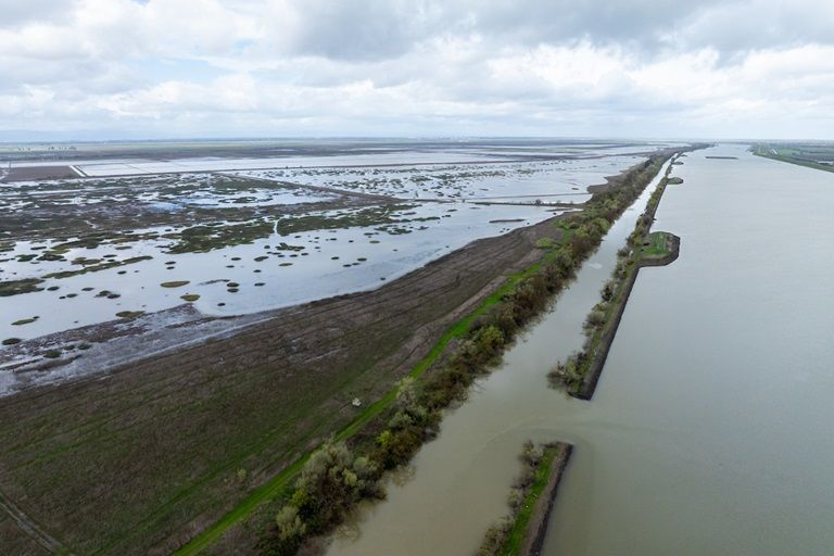
Since the 1950s, California’s salmon populations have dwindled due to lost habitat from a combination of factors, including human-made barriers such as dams, altered river flows, and climate change. These challenges mean DWR looks for opportunities to support salmon and other endangered species in its projects whenever possible. DWR’s Lower Elkhorn Basin Levee Setback (LEBLS) Project is a multi-benefit project where engineering, flood protection, and supporting nature all come together. While the primary goal of LEBLS is to reduce flood risk, the recently expanded bypass floodplain is producing zooplankton, an energy-rich invertebrate that’s a key part of the juvenile salmon diet. This food production is happening in significant quantities and sooner-than-expected.
How did this happen?
LEBLS is located north of West Sacramento and just west of the Sacramento River. The primary construction feature of the project set back the east levee by approximately 1,500 feet for the 5 miles along the Yolo Bypass and 2 miles of the north levee along the Sacramento Bypass. The construction of the new setback levee was completed in October 2023. This work expanded the Yolo Bypass, which floods seasonally and includes rice fields. DWR scientists knew this area would be valuable habitat for juvenile salmon because the inundated fields would have shallow, slow-moving, food-rich water.
What benefits were found?
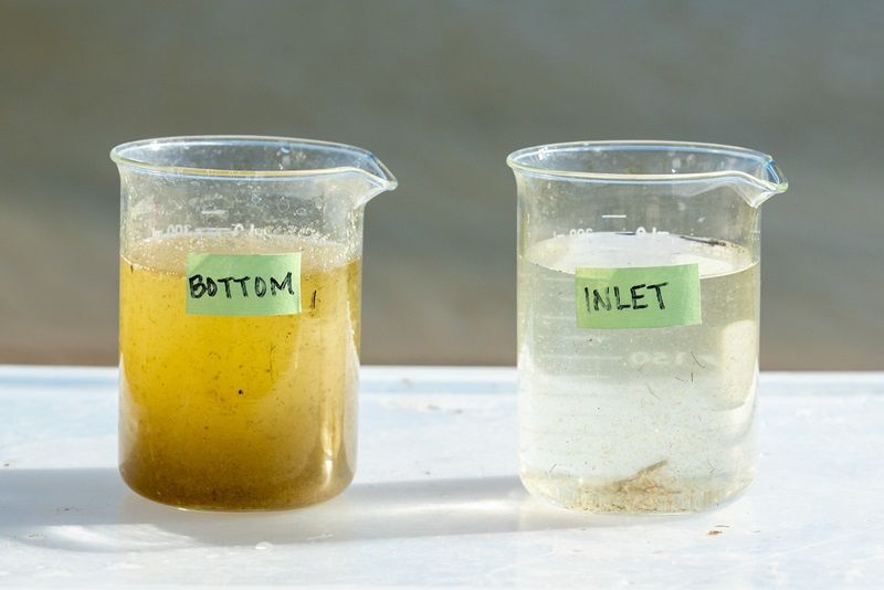
In December 2024 when LEBLS was finished with construction for the season, DWR and UC Davis scientists sampled the area after the bypass was flooded from winter storms and were impressed with how much zooplankton was produced. Scientists have gone back to the site since then to continue sampling with similar results. The photo below is from March 2025 and shows the difference in density of the zooplankton from two sites. The sample on the left was collected from the lower floodplain area of LEBLS and is loaded with energy-rich invertebrates. The sample on the right was taken from inlet water at the north end of the LEBLS project site and shows only scant invertebrate production. While the difference in zooplankton quantity between the two sites is easy to see, concrete data is needed to quantify and track the difference. The collected samples are sent to UC Davis to confirm how much zooplankton is being produced at LEBLS compared to other Yolo Bypass locations.
What was learned?
While scientists and project managers expected increased food production, the stark difference in food density between the two sites is impressive. These results show why it’s important for multi-benefit and habitat restoration projects to include early monitoring and adaptive management into their plans. In this case, early data collection is showing a better-than-expected outcome. However, projects may not always function as planned. DWR scientists recommend that multi-benefit and habitat restoration projects include robust monitoring and adaptive management components to ensure that goals and objectives can be reached in real world conditions.
What happens next?
DWR will collaborate with the Healthy Rivers and Landscapes Program and academic partners to better understand the benefit of increased food density at this site. DWR will also work with the Healthy Rivers and Landscapes Science Program to identify appropriate monitoring and adaptive management strategies for LEBLS. This work will be incorporated into a comprehensive long-term management plan, which will also fulfill regulatory requirements and guide land management.
What other benefits does LEBLS provide?
LEBLS was originally identified in the 2012 and 2017 Central Valley Flood Protection Plan (CVFPP), and it is the first State-led implementation of systemwide flood system improvements. The project helps meet the CVFPP Conservation Strategy objective of reconnecting historic floodplains and contributes to the recovery of target species.
Expanding the Yolo and Sacramento Bypasses with the new setback levee at LEBLS means improved public safety for 780,000 people in Sacramento, West Sacramento, and Woodland by increasing bypass capacity and reducing flood stage in the Sacramento River and Yolo Bypass. This protects approximately $53 billion in assets at risk of flooding. LEBLS connects to the US Army Corps of Engineers Sacramento Weir Expansion project, which will lower Sacramento River water levels by approximately one foot during high flow events, providing substantial flood risk reduction to urban areas in and around Sacramento. The project also benefits local agriculture through a new pump station and new interior drainage facilities.
Visit the LEBLS webpage to learn more about the project.
The project’s flood protection benefits were also highlighted in a
media event for California Flood Preparedness Week 2023.
While the difference in zooplankton quantity between the two sites is easy to see, concrete data is needed to quantify and track the difference. The collected samples are sent to UC Davis to confirm how much zooplankton is being produced at LEBLS compared to other Yolo Bypass locations.
What was learned?
While scientists and project managers expected increased food production, the stark difference in food density between the two sites is impressive. These results show why it’s important for multi-benefit and habitat restoration projects to include early monitoring and adaptive management into their plans. In this case, early data collection is showing a better-than-expected outcome. However, projects may not always function as planned. DWR scientists recommend that multi-benefit and habitat restoration projects include robust monitoring and adaptive management components to ensure that goals and objectives can be reached in real world conditions.
What happens next?
DWR will collaborate with the Healthy Rivers and Landscapes Program and academic partners to better understand the benefit of increased food density at this site. DWR will also work with the Healthy Rivers and Landscapes Science Program to identify appropriate monitoring and adaptive management strategies for LEBLS. This work will be incorporated into a comprehensive long-term management plan, which will also fulfill regulatory requirements and guide land management.
What other benefits does LEBLS provide?
LEBLS was originally identified in the 2012 and 2017 Central Valley Flood Protection Plan (CVFPP), and it is the first State-led implementation of systemwide flood system improvements. The project helps meet the CVFPP Conservation Strategy objective of reconnecting historic floodplains and contributes to the recovery of target species.
Expanding the Yolo and Sacramento Bypasses with the new setback levee at LEBLS means improved public safety for 780,000 people in Sacramento, West Sacramento, and Woodland by increasing bypass capacity and reducing flood stage in the Sacramento River and Yolo Bypass. This protects approximately $53 billion in assets at risk of flooding. LEBLS connects to the US Army Corps of Engineers Sacramento Weir Expansion project, which will lower Sacramento River water levels by approximately one foot during high flow events, providing substantial flood risk reduction to urban areas in and around Sacramento. The project also benefits local agriculture through a new pump station and new interior drainage facilities.
Visit the LEBLS webpage to learn more about the project.
The project’s flood protection benefits were also highlighted in a media event for California Flood Preparedness Week 2023.